Last Updated: 21st Sep 2023

Intermediate

Save Trail Save

I've done it Done

Whigs' Flying Fifty (WFF)

Christchurch, Canterbury

Submitted by Matt Doherty

Last Updated: 21st Sep 2023

Intermediate

Save Trail Save

I've done it Done

Grunt Factor: 60

Gnarl Factor: 24

50.3km

2070m

2060m

485m


Login as a VIP to see driving directions, distance and time.

Trail Map

Type of Run

Urban fringe

Point to Point (one way)

Undulating, some big hills

Dog Friendly

Coastal

Open farmlands

Open ridges/tops

Run Makeup

2%
30%
33%
35%

Sealed Road

Farm Road / 4WD Track

Easy Single Track

Moderate Single Track

Average Uphill Gradient: +8.5%

Average Downhill Gradient: -8.4%

Trailhead

Login as a VIP to see the trailhead information.

Estimated Times to Run

9.00:00

Slow

5.45:00

Moderate

4.15

Fast

N.B. While the track is dog friendly the first 2kms up the Crocodile are private and dogs are not allowed. Instead take the Kennedys Bush Rd to the junction of the Crocodile & Kennedys bush track.
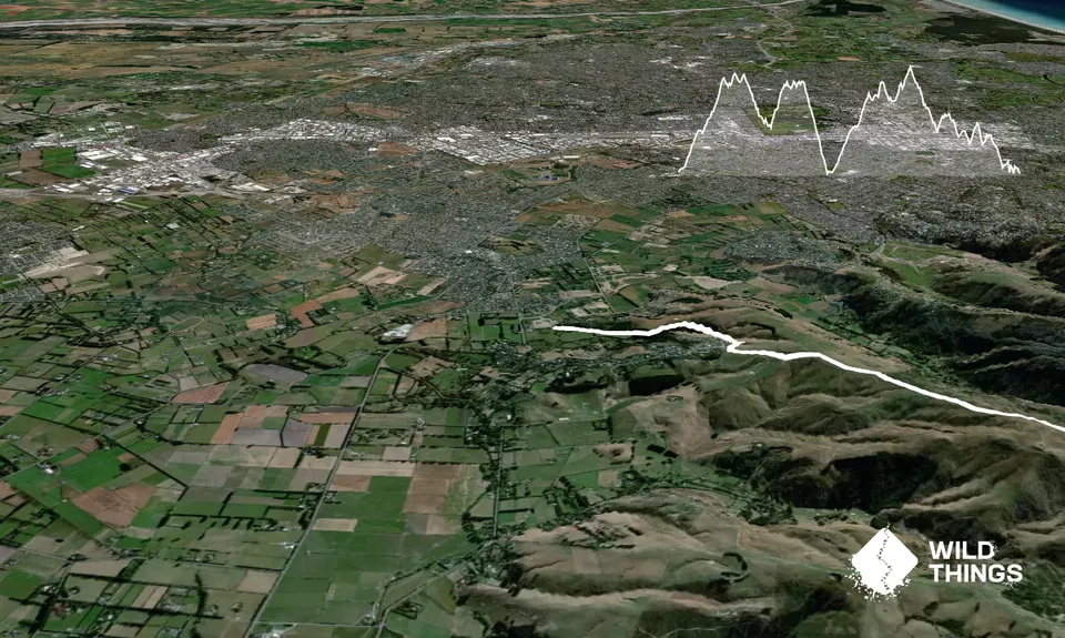
This trail is a great introduction to the Port Hills, it's based on the Old Crater Rim MTB race route but using the Crater Rim Walkway (CRW) to link up the mtb tracks intead of road sections. The section around Godley Heads was also lengthened to make the distance up to 50km.

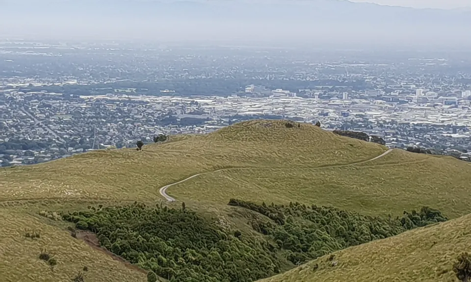
Start at the dog park and head along the base of the hill to the Crocodile track. Head up the original Crocodile trail (although any will do) cross Kennedys Bush track and follow the 3 winding mtb trails (Siberia etc) uphill, continue upwards on Kennedys Bush track to the Summit Rd.

Cross the road & turn left. Follow the CRW untill you rejoin the Summit Rd at Worsleys Rd. Go up Worsleys until you see a pylon track on your right just before the crest. Head up the pylon track then turn right onto the Flying Nun mtb track. This is an awesome, smiley track with big berms on the bends and interesting route choices (the outside choices are usually the best, however, be aware the first r/h bend does have a vertical smooth stone berm so check out the easy option shortcut just before it if you are unsure or if it's wet.)

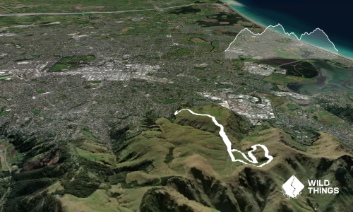
Follow this trail down past Sign of the Kiwi where it becomes Old Dyers Pass Rd (still single track). When you hit the tarseal after a few kms cross the road (Dyers Pass Rd tarseal) and pick up the mtb trail signs into Victoria Park and head up to the old skid area. From here head straight up the steep trail (any steep uphill here will do) until you intersect the mtb traverse track right below the summit rd. Head left and follow this underneath Sugarloaf until it intersects the Summit Rd again.

Cross the road and continue to follow the mtb track for a couple of kms until right after a switchback when you have dropped almost to the road. Turn left off the track, cross the road and head down Mt Vernon Farm Track. After a few km's the track splits, bear left and carry on down instead of flattening out. At the bottom you will hit the tarseal, take the first right then follow the road along the bottom of the hill to the left for approx 1km until you reach Rapaki road on your right.

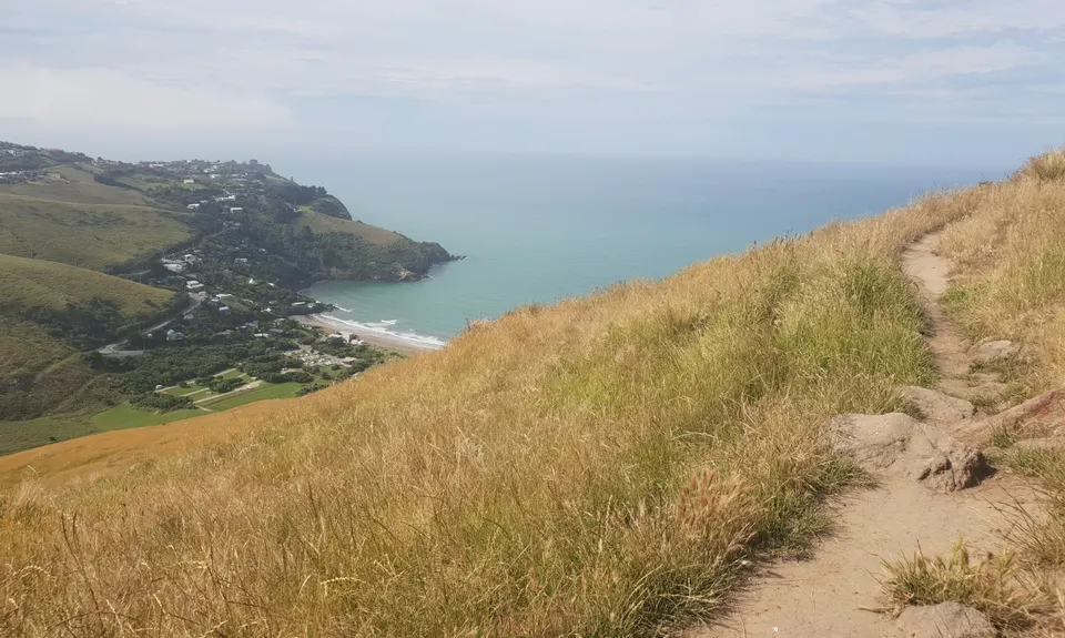
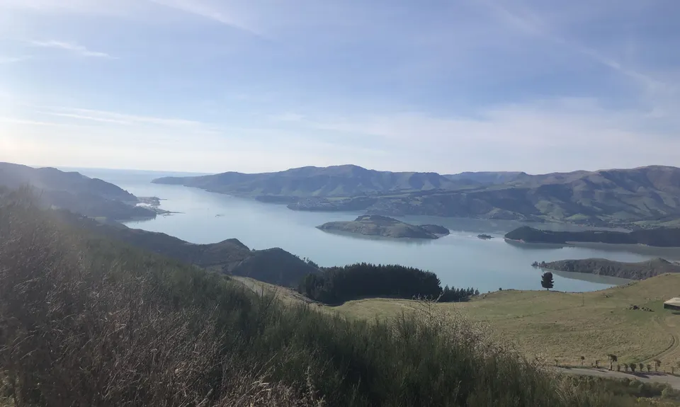
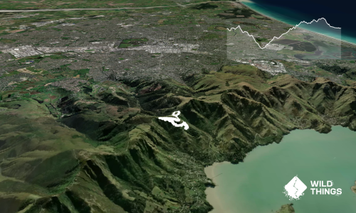
Head up Rapaki road/track again to the Summit Road. You will now roughly follow the Summit Rd all the way to Godley Heads. Cross the road, turn left and follow the Witch Hill track, cross the road & pick up the post quake walkway on the city side of the road to The Tors. Follow the Tors Walkway track to the Bridal Path. Continue in the same direction & aim to pass just behind the gondola building and drop to the next saddle.

From this saddle follow the Mt Pleasant Track (covered in light stone) up the next hill towards the radio towers that you will have seen from by the gondola. From the trig on top follow the trail down until you hit a farm track, turn left here, keep an eye to your right and pick up the Greenwoods mtb track after a couple of mins. Follow this trail down to the Summit Road at Evans Pass crossroads (4km down from trig to Summit Rd.)

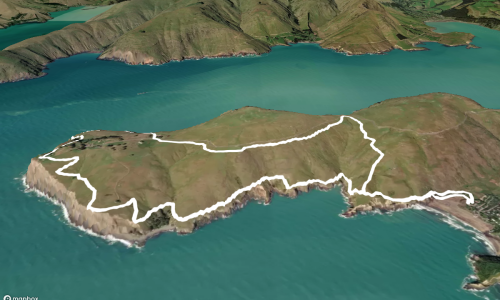
Go straight ahead at the crossroads, over the cattle stop and turn right onto the mtb track. Follow this track over the next 2 hills. On the 3rd hill from Evans Pass take the 2nd mtb track up the hill to your right (neither are signed but both are only a few meters along from when you hit the road) . Follow this on the main track until you hit a junction. Turn right towards the signed summit mtb track. At the fenceline turn right and either follow the fence or the marker poles along the top then back down to the saddle. Now look to your left and take the stile over the fence, follow this track on the harbour side of the hill untill you cross another stile. Don't drop just yet but head leftish until you pass the old WW2 building and take the next right onto a farm track that will drop to Godley Heads Car park. Go over the stile into the car park and take the track on the harbour side and follow this round to the finish Taylers Mistake.

Start - Halswell Quarry Dog Park
Finish - Taylers Mistake Surf Club.
No bus to Taylers. Normally easy to hitch over the hill to Sumner of only an extra few km's run if you are bussing!

11 km

18 minutes

Yes

No

Easy.

Generally good.

Waterproof leggings, Long-sleeved thermal top, Seam-sealed waterproof jacket, Gloves, Beanie/thermal headwear, Whistle, First aid kit, Extra food for emergencies, Survival bag, Cellphone, Map.

Halswell Quarry Park
Sign of the Kiwi
Victoria Park
Godley Heads
Taylers Mistake

Can be nasty on exposed ridges and saddles in a strong Southerly.
Flying Nun - Rock berms sketchy when wet as polished by tyres

Mountain bikes on 50% of the trail.
Flying Nun is now a downhill trail and can get pretty busy with bikes so keep an ear out.

You and Whigs' Flying Fifty (WFF)

As a VIP member you can record private notes for this trail, see all of your times and more.

Register Now

Already have an account? Login now

Trail Reviews

Wow, this was a giant tour of the Port Hills MTB tracks! It was a departure from the usual Crater Rim route, so there were a couple of new tracks for me :) The weather was hot, sunny, and still today so it was a bit tougher than expected. Don't underestimate this one. Also it was Whigs Flying Forty-nine due to the Godley Head asbestos closures.

Matt Halverson

September 4, 2021

Did this again and forgot the observation I made of not doing the MTB trails on a busy Sunday! Got 45km again this time but had to divert of a coup,e of the bike trails as just too busy with waving bikes through, Save this one for a weekday, its a goodun especially with the extra drop down Vernon and back up rapaki

Tony Sharpe

September 15, 2020

Finally got this off the watchlist! Great afternoon out training for those longer missions. Being the weekend the mountain bike section along bowenvale was worth avoiding. Great mission

Tony Sharpe

December 9, 2018

Awesome run that becomes a 5 star instead of a 4 star for me by 1 subtle change - On the descent down Mt Vernon Farm Track, dont "bear left" as per the original decription and go straight ahead instead, this will lead you to the Dry Ridge Track, follow this to the valley floor where you shoud turn right and head back uphill on Valley Track, this great wee route will bring you onto Rapaki track just before the last climb to the sumit.

Matt Doherty

November 19, 2018

Login to submit a review

Trail Running Community

Find people who are interested in or have completed this trail run.

You must register or login to view this feature.

Register Now

Overlapping Trails

These overlap with this trail to some degree. You may wish to combine them but please note that to qualify for FKTs on these runs you should record a separate activity for each.

Godley Head loop

Godley Head loop

Length: 18.1km

Level: Intermediate

Sumner Half Heads

Sumner Half Heads

Length: 21.6km

Level: Beginner - Intermediate

VKV challenge

VKV challenge

Length: 10.0km

Level: Intermediate

The ATH (Around The Harbour)

The ATH (Around The Harbour)

Length: 61.4km

Level: Intermediate

The Crater Rim

The Crater Rim

Length: 27.9km

Level: Intermediate

Port Hills Spur Challenge!

Port Hills Spur Challenge!

Length: 18.5km

Level: Intermediate

Christchurch 360 Trail - Sugarloaf Hills Section

Christchurch 360 Trail - Sugarloaf Hills Section

Length: 18.2km

Level: Intermediate

The North Faces

The North Faces

Length: 24.8km

Level: Beginner - Intermediate

Other trails nearby
Montgomery Loop

Montgomery Loop

Length: 7.9km

Level: Beginner - Intermediate

Orton Odyssey

Orton Odyssey

Length: 13.6km

Level: Beginner - Intermediate

Gondola Gallop

Gondola Gallop

Length: 11.3km

Level: Beginner - Intermediate

Heathcote River Run - Opawa to Hoon Hay

Heathcote River Run - Opawa to Hoon Hay

Length: 9.2km

Level: Beginner

Find more trails and peaks nearby