Last Updated: 27th Jan 2024

Intermediate

Save Trail Save

I've done it Done

Lyttelton to Diamond Harbour

Christchurch, Canterbury

Submitted by Mark Rigby

Last Updated: 27th Jan 2024

Intermediate

Save Trail Save

I've done it Done

Open

Grunt Factor: 53

Gnarl Factor: 28

43.5km

1700m

1700m

919m


Login as a VIP to see driving directions, distance and time.

Trail Map

Type of Run

Front country - easily accessible

Point to Point (one way)

Undulating, some big hills

Native bush

Plantation/exotic forest

Open farmlands

Open tussock/grasslands

Volcanic

Run Makeup

20%
5%
20%
15%
30%
10%

Sealed Road

Gravel Road

Farm Road / 4WD Track

Easy Single Track

Moderate Single Track

Technical Single Track

Average Uphill Gradient: +9.3%

Average Downhill Gradient: -8.5%

Trailhead

Login as a VIP to see the trailhead information.

Estimated Times to Run

7:00

Slow

5:15

Moderate

3:30

Fast

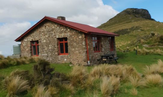
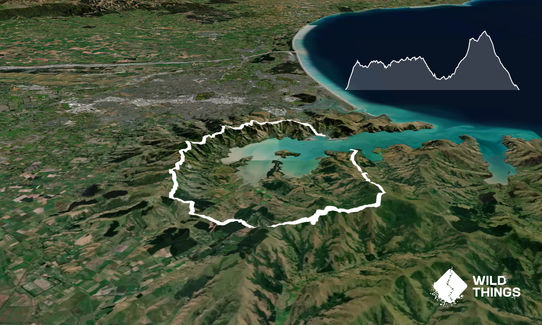
This route starts in Lyttelton and ends in Daimond Harbour. Plenty of parking in Lyttleton ( tip: park on main road close to ferry so you don't have far to get to your car when you return by ferry). Find your way (signposted) to the start of the Bridal Path track and follow to Summit Rd. Turning left onto Summit Rd you can either run the road right to Gebbies pass (24km) or take the Crater Rim Track or a mix of both. Where Summit Rd meets Gebbies Pass Rd turn left and run 100m and Packhorse Hut Track starts here on the right hand side and is clearly marked from this point. The track undulates for a few kms from here before climbing to a saddle where you'll find the hut (approx. 29k).
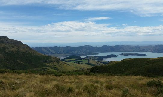
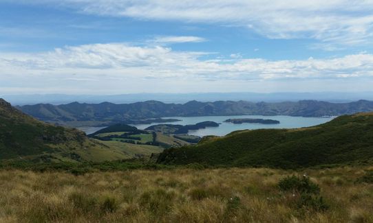
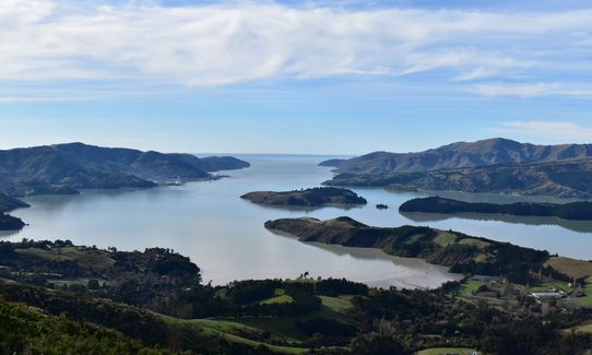
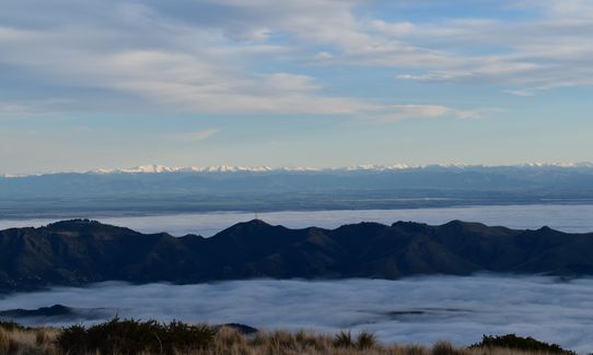
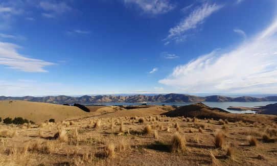
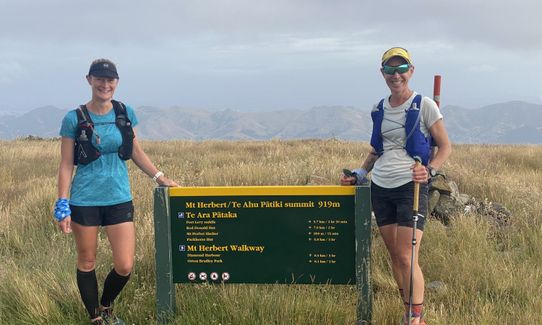
From here take the track that works it's way around the back of Mt Bradley. The track starts with a steady climb and gets steeper for some time as you climb to near the top of Mt Bradley where the track undulates it's way across to the Mt Herbert shelter (approx 35k). The views on a good day from Packhorse Hut and Mt Herbert go for ever towards Lyttleton, Chch, the alps, Kaikoura and Banks Peninsula when you look the other way.
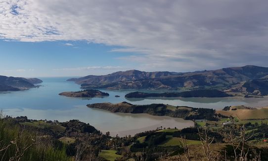
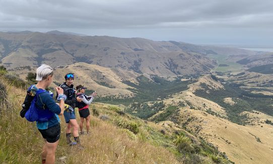
From the Shelter it's a short climb to the top of Mt Herbert before a rewarding descent to Daimond harbour. The track is well marked (around 7k to the bottom) and when you reach the main road you take a right turn and a couple of hundred metres along the road you will see a sign post with Diamond Harbour Jetty/Ferry and you take a left turn and the jetty is approx. 1km from this sign. Ferries leave approximately every 30 min. Price currently is $6-50 one way. Nice way to end a great journey.

Track passes the following:
Sign of the Kiwi, Sign of the Bellbird, Gebbies Pass, Packhorse Hut, Mt Bradley & Mt Herbert


Good parking in Lyttelton.
Return from Diamond Harbour by Ferry which leaves jetty every 30 minutes.
Cost around $6-50

13 km

19 minutes

Unknown

No

Moderate.

Perfect throughout.

Long-sleeved thermal top, Seam-sealed waterproof jacket, Gloves, Beanie/thermal headwear, Whistle, First aid kit, Extra food for emergencies, Survival blanket, Cellphone, Map, Headtorch and spare batteries.

Sign of the Kiwi Approx 10k
Packhorse Hut Approx 29k
Mt Herbert Shelter Approx 35k

Very exposed around Packhorse Hut, Mt Bradley and Mt Herbert in Southerly conditions.
Parts of Mt Herbert Track closed during lambing season. Generally mid-Aug until mid-Sept.

Freemans Dining Room
47 London St Lyttleton
Rated No 1 in Lyttleton on trip advisor. Personally been there a number of time and coffee is great along with a good food menu and range of Alcoholic drinks. Craft Beer etc.

Lyttleton Coffee Company
29 London St Lyttleton
http://www.lytteltoncoffee.co.nz

Trail Legend

Emily Oliver

Emily Oliver

has completed Lyttelton to Diamond Harbour twice in the last year.

Learn about Trail Legends.

You and Lyttelton to Diamond Harbour

As a VIP member you can record private notes for this trail, see all of your times and more.

Register Now

Already have an account? Login now

Trail Reviews

I did this in the direction described, which during this heatwave was perfect to get a swim off the jetty at Diamond Harbour at the end. Probably a bit faster run in reverse, but I really enjoyed it this way (plus you don't have to run up "the bastard" this way!). On the Lyttelton side you can keep to the Crater Rim trails all the way to Omahu Bush if road isn't your jam. Gebbies to Packhorse has sadly lost a lot of tree cover due to forestry so beware of extra heat and sun exposure and take enough water to get you to the Packhorse (Rhodes Spring below Cooper's Knob is usually a good source but just a trickle atm, you will have to take the road for that section to pass it). Round the back of Mt Bradley is pretty overgrown and hard going right now, but the rest of the route is sweet. Also bonus, ferry fares are 50% discounted until end of June 2023.

Emily Oliver

February 6, 2023

Ran this in reverse. So good! Worth waiting for a nice day. Stuck to the Crater Rim Walkway and had about 2100m climbing total. Came down Stan Helms rather than Bridle Path, with drinks at Eruption to finish.

Matt Halverson

March 27, 2022

Really enjoyed this run. As per some of the other comments I also did it reverse so as not to have to wait for the ferry. I thought the first half (over Mt Herbert etc) was slower going than the second (overgrown grass obscuring the track a bit in places) so was happy to have done it that way. Did a mix of summit rd and crater rim track. Nice running on the track. Had to get my gloves on at the summit of Mt Herbert - in January!

Christina Clarke

January 7, 2022

Great run! I did this in reverse to make the ferry logistics easier and to make sure that the mandatory ice cream from Sign of the Kiwi was ~30km - just when I needed it! Big day out but a great substitute for the Motatapu Marathon which COVID-ed....

Amy Whitehead

March 7, 2021

Login to submit a review

Trail Running Community

Find people who are interested in or have completed this trail run.

You must register or login to view this feature.

Register Now

Overlapping Trails

These overlap with this trail to some degree. You may wish to combine them but please note that to qualify for FKTs on these runs you should record a separate activity for each.

Banks Peninsula Ultra Beer Run

Banks Peninsula Ultra Beer Run

Length: 50.0km

Level: Experienced

Gebbies to Packhorse Romp

Gebbies to Packhorse Romp

Length: 11.4km

Level: Beginner

The ATH (Around The Harbour)

The ATH (Around The Harbour)

Length: 61.4km

Level: Intermediate

A Diamond in the Rough

A Diamond in the Rough

Length: 19.0km

Level: Beginner - Intermediate

Other trails nearby
Lyttelton Dress Circle

Lyttelton Dress Circle

Length: 9.0km

Level: Intermediate

VKV challenge

VKV challenge

Length: 10.0km

Level: Intermediate

Horse Latitudes

Horse Latitudes

Length: 5.1km

Level: Beginner

Morgans Baa Baa Loop

Morgans Baa Baa Loop

Length: 5.2km

Level: Beginner

Find more trails and peaks nearby