Last Updated: 11th Mar 2024

Beginner - Intermediate

Save Trail Save

I've done it Done

Christchurch 360 Trail - Godley Cliffs Section

Christchurch, Canterbury

Submitted by Tony Sharpe

Last Updated: 11th Mar 2024

Beginner - Intermediate

Save Trail Save

I've done it Done

Open

Grunt Factor: 20

Gnarl Factor: 42

16.1km

400m

700m

501m


Login as a VIP to see driving directions, distance and time.

Trail Map

Type of Run

Urban fringe

Point to Point (one way)

Undulating, some big hills

Dog Friendly

Open farmlands

Open tussock/grasslands

Open ridges/tops

Volcanic

Run Makeup

30%
60%
10%

Easy Single Track

Moderate Single Track

Technical Single Track

Average Uphill Gradient: +9.2%

Average Downhill Gradient: -11.4%

Trailhead

Login as a VIP to see the trailhead information.

Estimated Times to Run

3:00

Slow

2:30

Moderate

2:00

Fast

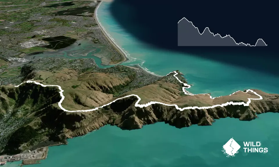
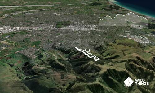
The full 360 Trail is a 135km loop around ChCh on a mix of urban trails and tracks. If you are nuts you could try the whole lot in one go, but you'll need the best part of 24 hours for that. Instead the 360 Trail concept is an Urban "Great Walk" designed to be ticked off in several discrete stages. Godley Cliffs is the second section of the 360 Trail and if you want a longer full traverse of the Port Hills hook it together with the Sugarloaf Hills section which starts over in Halswell, or the Crater Rim Trail.

If you've come up via the Gondola drop down the zig zag track down to the saddle. From here kick off into the gradual climb up the shared use MTB/walking trail as it sidles and zigzags up to the top of Mt Pleasant. Alternately for a more direct route head straight up the hill cross country where you'll pick up sections of the pre-EQ Crater Rim route.

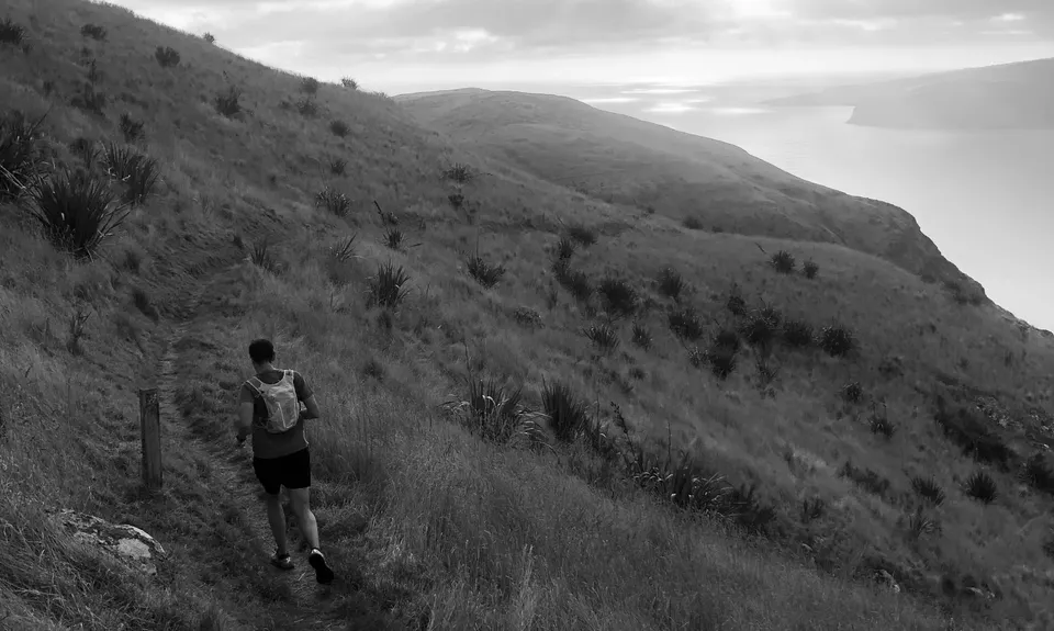
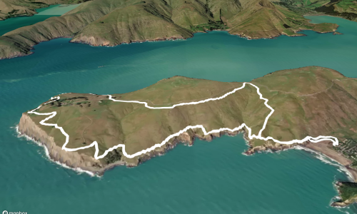
From Mt Pleasant it's more shared use track down and round to the historic bunkers, which are always a great spot for a photo or two. Hop onto the Crater Rim Trail here and get rid of those MTB's for a more direct descent down and round to Evans Pass. Cross the road and cattlestop and then follow the Crater Rim all the way out to the Godley Head Carpark.

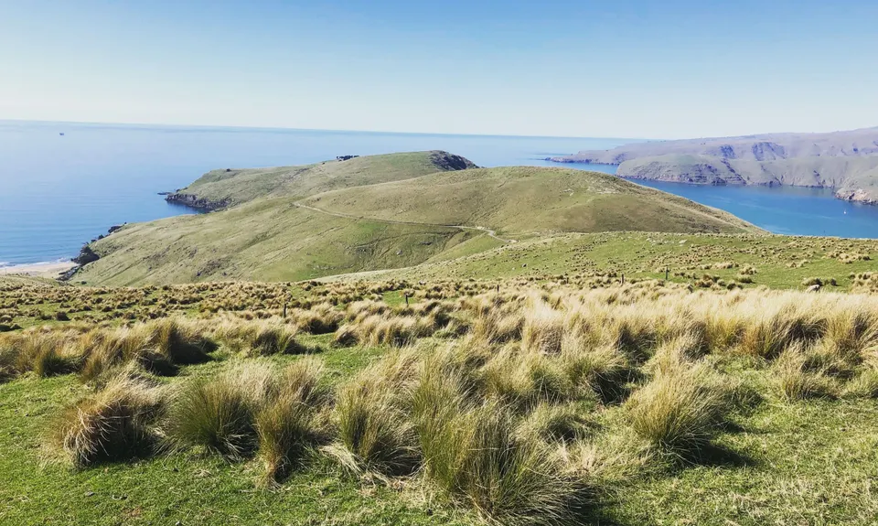
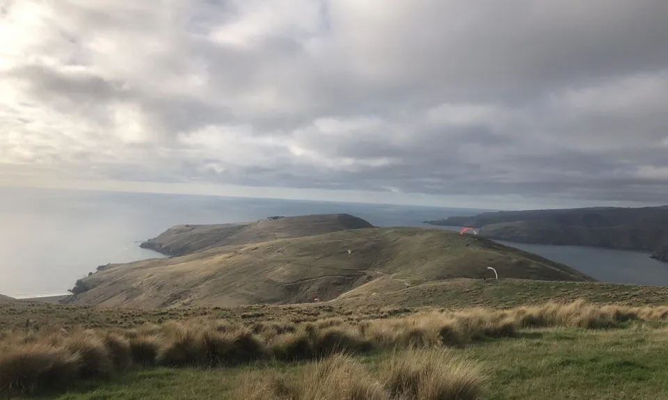
There are some truly gobsmacking views of the Lyttleton Harbour entrance through here. From Godley Head the 360 Trail actually follows the old track down to Boulder Bay, bypassing the Gun Emplaceements on Godley Head. You may wish to take the new trail that tours these historic buildings instead. You can also camp at Godley head these days too, a great place for night sky and sunrise viewing. Nice easy undulations take you round the bays to Taylors Mistake where you need to zip across the sandy beach and pick up the trail up to Scarborough head as it ducks, dives and zigzags around some baches and then some truly palatial homes. Up over the daunting cliffs of Whitewash Head, then down through Nicholson park and you'll hit the end of this section of the 360 Trail at Sumner Beach.

Historic gun emplacements and bunkers. Spectacular views of Lyttelton Harbour and Pegasus Bay. Christchurch 360 Trail

Catch the Gondola up to start, or get dropped off by your friendly support crew who can drive up via Mt Pleasant

14 km

26 minutes

Yes

No

Easy.

Follow the koru shaped 360 Trail markers

Perfect throughout.

Long-sleeved thermal top, Seam-sealed waterproof jacket, Windproof jacket, Beanie/thermal headwear, Whistle, First aid kit, Extra food for emergencies, Cellphone, Map.

There's water at the Godley Head Carpark, and at Taylors Mistake

Can get pretty greasy after rain and fogbound in inclement weather

Note the weather forecast, it can be pretty savage on the Port Hills in a storm

Lots of options for R&R in Sumner.

Trail Legend

Rebecca Sunderland

Rebecca Sunderland

has completed Christchurch 360 Trail - Godley Cliffs Section once in the last year.

Learn about Trail Legends.

You and Christchurch 360 Trail - Godley Cliffs Section

As a VIP member you can record private notes for this trail, see all of your times and more.

Register Now

Already have an account? Login now

Trail Reviews

This is a really great flowy route with spectacular views and a nice cafe at the end. I did it in the suggested direction and dropped my bike off at the clock tower cafe. I then parked at the Gondola, had a lift up the hill ($20 for locals) ran the route and biked back to the car - easy as.

Stefanie Parks

September 1, 2022

Another classic , thanks Tony, though we always make it a loop unless dropping a bike off at one end. Loop adds extra km on with a variety of tracks or roads heading down or up depending which way you prefer the loop.

Sia Svendsen

June 20, 2021

This is a great wide easy trail. It's been graded and re graveled over Lockdown, steps fixed and rails added and potholes/ruts filled in. It's wide enough for two people, prams etc. It's got grunty little climbs and it's got lots of historical places to stop and look at if you need an excuse to catch your breath. Go early in the morning and enjoy the sunrise, as it gets busy later in the day with walkers and family groups enjoying the adventure, especially on the weekends. Stunning views of Lyttleton Harbour on one side and Christchurch and the Canterbury coastline on the other. A good confidence building adventure!

Vanessa Gopperth

August 16, 2020

Simply gorgeous views on a fine winters day. Ran it in the stated direction (walked up Bridle Path as a warmup) and thoroughly enjoyed it, having also run the other way in the past. Lots of great single track - this has gotta be my personal favourite run in the Port Hills.

Matt Halverson

June 14, 2020

Login to submit a review

Trail Running Community

Find people who are interested in or have completed this trail run.

You must register or login to view this feature.

Register Now

Overlapping Trails

These overlap with this trail to some degree. You may wish to combine them but please note that to qualify for FKTs on these runs you should record a separate activity for each.

Godley Head loop

Godley Head loop

Length: 18.1km

Level: Intermediate

Sumner Half Heads

Sumner Half Heads

Length: 21.6km

Level: Beginner - Intermediate

Gang of Four

Gang of Four

Length: 15.7km

Level: Beginner - Intermediate

Trinity - Harbour Bruisin'

Trinity - Harbour Bruisin'

Length: 20.1km

Level: Intermediate

Gates Of The East

Gates Of The East

Length: 14.0km

Level: Beginner - Intermediate

Other trails nearby
The Gorsetrack Strikes Back

The Gorsetrack Strikes Back

Length: 14.0km

Level: Beginner

Boulder Dash

Boulder Dash

Length: 21.5km

Level: Intermediate - Experienced

Takahe to Taylors

Takahe to Taylors

Length: 21.0km

Level: Beginner - Intermediate

Rapaki Sugarloaf Return

Rapaki Sugarloaf Return

Length: 15.0km

Level: Beginner - Intermediate

Find more trails and peaks nearby