Last Updated: 13th Mar 2024

Beginner - Intermediate

Save Trail Save

I've done it Done

Port Hills 8-Attack

Christchurch, Canterbury

Submitted by Simon Dunlop

Last Updated: 13th Mar 2024

Beginner - Intermediate

Save Trail Save

I've done it Done

Notice More info

Grunt Factor: 35 ?

Gnarl Factor: 49 ?

17.7km

1305m

1290m

480m


Login as a VIP to see driving directions, distance and time.

Trail Map

Type of Run

Urban fringe

Loop

Undulating, some big hills

Native bush

Plantation/exotic forest

Open tussock/grasslands

Open ridges/tops

Volcanic

Run Makeup

5%
5%
30%
30%
30%

Sealed Road

Farm Road / 4WD Track

Easy Single Track

Moderate Single Track

Technical Single Track

Average Uphill Gradient: +14.4%

Average Downhill Gradient: -14.2%

Trailhead

Login as a VIP to see the trailhead information.

Estimated Times to Run

3:15

Slow

2:45

Moderate

2:00

Fast

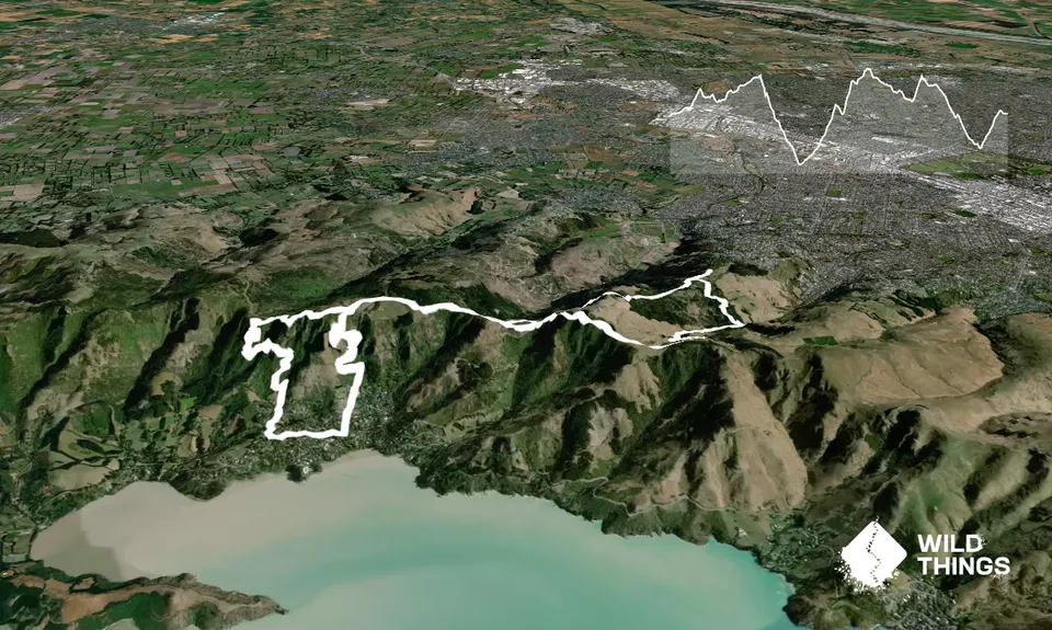
From the carpark on the Victoria Park Road (opposite dog exercise area), head down the Tawhairanui Trail, popping onto the road and back to the trail before emerging on the road again at the 19th Battalion Memorial and cross the road and go up the wide shingle road with the gated entrance.

Continue along here, past the trail junction and water fountain to follow the Latters Spur track just to the left of the main ascent straight ahead. Rejoin the main ascent and keep left at the fork to go up some broad steps, passing through two spring gates.

Follow the orange poles and then just before Summit Road, hang a right onto Thompsons Track. Follow this / Summit Road around to Sign of the Kiwi. Take the Coronation Reserve trail up the steps to the left of the café and then continue on the Crater Rim to the Hoon Hay Scenic Reserve carpark.

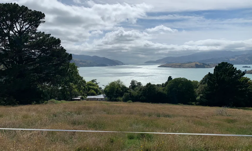
Cross the stile and head uphill to cross another stile. Straight ahead is Faulkners Track. This is a gem of downhill switchbacks – take some time to stop and enjoy the view down Lyttleton Harbour and marvel at the steepness of the hill face below.

Continue on Faulkners all the way to the bottom – watch for the right hand turn to stay on this track about 2/3 of the way down. When you exit the track onto sealed road, look straight across the road for a timber and corrugated iron fenced set of steps down and carry on with a further short section of trail here. You will arrive back on the road and continue to a dead-end where you will see faint wear on the grass at the right-hand side – follow this and continue down the rough road to the main road through Governor’s Bay.

Suck up some pavement to get around to the fire station on Earnest Adams Drive (watch out for yellow signs pointing to fire station and Ohinetahi tracks). Turn right and go past the fire station. The road veers right (Bay Heights) - on the bend, look for a track on the left side through the grass / bush where there is a slightly hidden gate labelled “Titoki Track”. Continue for a short while on Titoki until it forks and take the left-hand track (Ngaio).

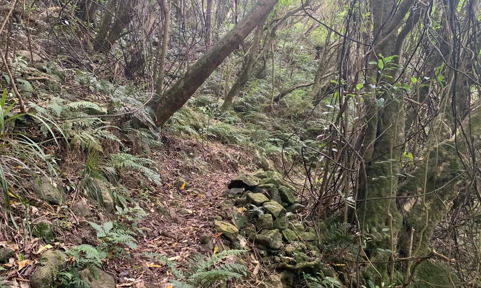
First serious dose of vert here! Eventually Ngaio connects back with Titoki - follow this and then continue straight to carry on to South Boundary. This track is akin to passing through the wardrobe into Narnia – this is one of the highlights of the run, with canopied bush conditions typical of many of Governor’s Bay’s best tracks: gloomy lighting courtesy of old Five Finger canopy and dusty leaf litter mixed with roots and rocks underfoot. Thereafter it gets a little more like hard work.

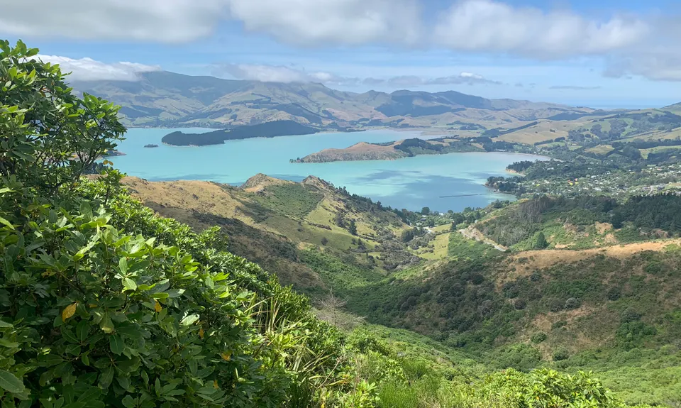
Ignore Duke Street on your right and carry onto Bush Road. This elevates you, at times quite steeply, back up to the Crater Rim. Turn right at the top and after coming down to road-level keep an eye our for a right turn onto the Trig V detour to gain some extra vert and some more stunning harbour views.

Back over the stile to Hoon Hay Reserve and continue on Crater Rim all the way to Sign of the Kiwi. Cross Dyers Pass Road here to the steps heading up the hill (Sugarloaf) in front of you. Take the 2nd right – Gilpins Track – for some more leg trashing vert before catching your breath in some lovely shady bush. Pop out onto Summit Road, crossing the road and stile and heading right on the Bowenvale Traverse. Great views down the valley and Bowenvale Ave to the City.

Next is some good old quad smashing downhill – veer left to take the wide swathe of grassy track that is the Bowenvale Valley track. After a few hundred metres, watch out for the trail marker that guides you left to stay on the Bowenvale Valley Track. You now get some flowing and smashable single track – watch for the next junction where you need to take a right. Cross a couple of footbridges to come out on the wide shingle trail / road.

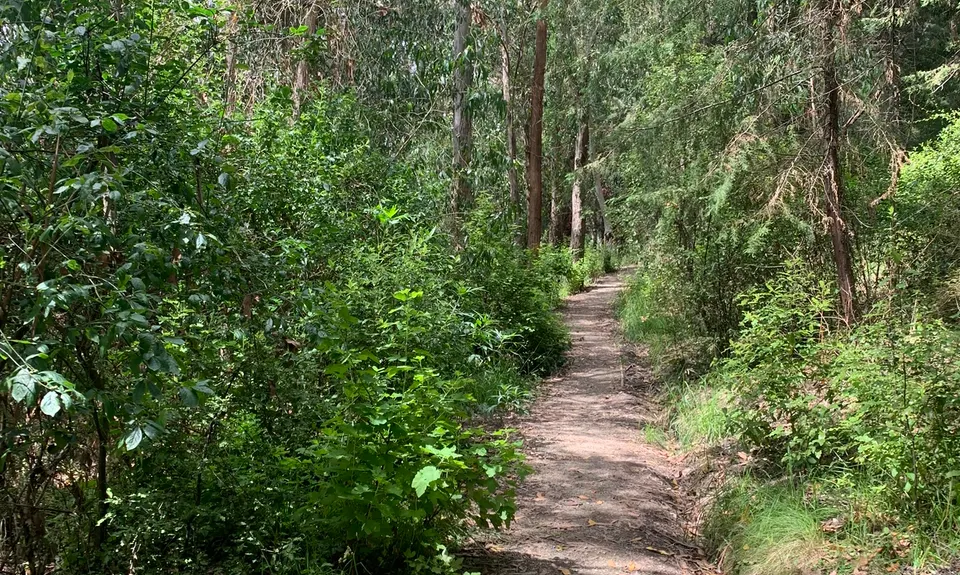
On approaching a large grove of tall pine trees look for a track to the left (there are two entrances if you miss the first, which is not actually named). This is the East Side Bush Track that elevates you back up to Victoria Park. Pass through shady pine, fir and macrocarpa trees, eventually giving way to Eucalypt and native shrubs as your vert clock heads past 1,000m.

Keep an eye out for the first critical turn – a right hand turn firstly after a set of wooden steps, then left at the next junction, then right again to head back up into the trees. You are almost there when you see a set of stone steps to your left that pop you out in the main Vic Park carpark.

Go up the sealed road straight/left – look out for the trail into the bush on your right not far past the corner. Head down and take a right at the first juncture to continue back to the starting point on the Tawhairanui Trail.

This trail includes the peak Sugarloaf.

Governor's Bay trails / Ohinetahi Reserve provide great views, superb techy trails, and a lot of vert! Bellbird and Grey Warbler song if you are lucky

If car park is full, the main carpark just further on usually has some space. Can bus from central city to Sign of the Takahe, with a short walk into Victoria Park.

8 km

14 minutes

Unknown

No

Easy.

Easy to head straight on Faulkners when you need to go right - read the wooden signs when you go through track intersections.
The gate into the Titoki Track in Governor's Bay can be easily missed when running onto Bay Heights a little way past the fire station.
The entrance to Eastside Bush Track from the valley floor - it is a narrow rocky entry. If you take the 2nd entrance, keep left (right will take you out to Bowenvale Ave).
Take care to follow the right / left / right on Eastside Bush Track.

Generally good.

Long-sleeved thermal top, Seam-sealed waterproof jacket, Beanie/thermal headwear, Personal Locator Beacon (PLB), Whistle, First aid kit, Extra food for emergencies, Cellphone, Map

Water available at Sign of the Kiwi (good to refill here before going onto Sugarloaf / Gilpin's Track)

Can get pretty cold on the tops any time of year in a southerly or strong easterly. Some parts of the run will be slippery / muddy after rain e.g. Bowenvale downhill, Governor's Bay tracks.

Take care on steep descent on Faulkners, especially the initial switchbacks.
Can be gorse and blackberry intrusion on the Governor's Bay tracks.
Take care crossing Governor's Bay main road after coming down Faulkners - the bend is quite blind.

Sign of the Takahe Cafe / Bar
200 Hackthorne Road
https://signofthetakahe.co.nz/
Handily close, good menu and licensed premises

Trail Legend

Sam Mowat

Sam Mowat

has completed Port Hills 8-Attack once in the last year.

Learn about Trail Legends.

You and Port Hills 8-Attack

As a VIP member you can record private notes for this trail, see all of your times and more.

Register Now

Already have an account? Login now

Trail Reviews

This trail has everything! +1 for Ohinetahi goodness. Ran it after a couple days of rain and it certainly slowed things down a bit. Even though I had run all these trails before, it still felt like an adventure. Good muddy fun :D I was grateful to have poles for Ohinetahi purely for traction.

Matt Halverson

July 23, 2022

A pretty good variety of trails, and anything that gets people into the Ohinetahi Reserve gets a vote in my books. There are a few overlaps with the other Governor's routes in WT, but the Bush Road climb is one of my favourites on the Port Hills so all is forgiven. As Daniel mentions, you need to drop down off the South Boundary track - it feels counterintuitive, but it will get you to the bottom of the Bush Road section. If you miss the turnoff, I'm pretty sure it links partway up the climb, so you'll just miss a bit of vert. Sending the route down into Bowenvale before climbing back out is the best type of sadistic.

Brion Matthews

March 22, 2022

A nice mix of trails here. The description is missing a turn, though. On the way back up to the Summit Rd from Governors Bay, on arriving at the South Boundary track, turn LEFT even though the sign on at the start of a the South Boundary track on the right side. This descends for a short while and then take the Bush Rd track to the summit.

Daniel Parkinson

March 6, 2022

Login to submit a review

Trail Running Community

Find people who are interested in or have completed this trail run.

You must register or login to view this feature.

Register Now

Overlapping Trails

These overlap with this trail to some degree. You may wish to combine them but please note that to qualify for FKTs on these runs you should record a separate activity for each.

The Gorsetrack Strikes Back

The Gorsetrack Strikes Back

Length: 14.0km

Level: Beginner

Sign Of The Takahe - Rapaki

Sign Of The Takahe - Rapaki

Length: 13.0km

Level: Beginner - Intermediate

VKV challenge

VKV challenge

Length: 10.0km

Level: Intermediate

Lava - H.ELL Loop

Lava - H.ELL Loop

Length: 10.3km

Level: Intermediate

The Guv'nor & His Birds

The Guv'nor & His Birds

Length: 16.0km

Level: Intermediate - Experienced

The Crater Rim

The Crater Rim

Length: 27.9km

Level: Intermediate

Takahe Half

Takahe Half

Length: 21.1km

Level: Beginner - Intermediate

Pour Some Sugarloaf On Me

Pour Some Sugarloaf On Me

Length: 8.3km

Level: Beginner - Intermediate

Vicki Vale

Vicki Vale

Length: 9.3km

Level: Intermediate

Christchurch 360 Trail - Sugarloaf Hills Section

Christchurch 360 Trail - Sugarloaf Hills Section

Length: 18.2km

Level: Intermediate

Bird to Bird

Bird to Bird

Length: 9.8km

Level: Beginner - Intermediate

Port Hills Protocol

Port Hills Protocol

Length: 32.0km

Level: Intermediate

The Governator

The Governator

Length: 9.9km

Level: Intermediate - Experienced

Governator 2 - Judgement Day

Governator 2 - Judgement Day

Length: 7.7km

Level: Intermediate

Other trails nearby
Surf's Up!!!

Surf's Up!!!

Length: 5.2km

Level: Beginner

Never Trust A Crocodile

Never Trust A Crocodile

Length: 6.1km

Level: Beginner - Intermediate

360 Trail - Dunes Wetlands Section

360 Trail - Dunes Wetlands Section

Length: 15.9km

Level: Beginner

Holliss Stairway to Heaven

Holliss Stairway to Heaven

Length: 8.7km

Level: Beginner - Intermediate

Find more trails and peaks nearby