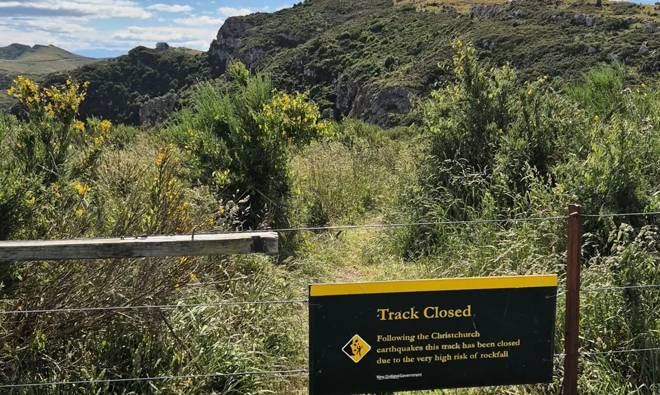
Last Updated: 21st Sep 2023

Intermediate - Experienced

Save Trail Save

I've done it Done

Boulder Dash

Christchurch, Canterbury

Submitted by Brion Matthews

Last Updated: 21st Sep 2023

Intermediate - Experienced

Save Trail Save

I've done it Done

Grunt Factor: 35

Gnarl Factor: 49

21.5km

1200m

1200m

412m


Login as a VIP to see driving directions, distance and time.

Trail Map

Type of Run

Urban fringe

Loop

Undulating, some big hills

Native bush

Plantation/exotic forest

Open farmlands

Open tussock/grasslands

Open ridges/tops

Run Makeup

14%
19%
7%
30%
22%
8%

Sealed Road

Farm Road / 4WD Track

Easy Single Track

Moderate Single Track

Technical Single Track

Untracked / Route only

Average Uphill Gradient: +14.9%

Average Downhill Gradient: -15.0%

Trailhead

Login as a VIP to see the trailhead information.

Estimated Times to Run

4:45

Slow

3:45

Moderate

2:30

Fast

This is a Port Hills tour of a few favourite 'closed' tracks. They are well frequented, and considered safe, but please enter at your own risk.

Jump the culvert through to the empty section directly opposite Paisley Street and head to the rear left of the section. There is a little track cut here that winds up to the Old Captain Thomas Track. Carry along this uphill. Note the Ngaio tree with the white tag on it - you'll pop out somewhere around here at the end if you're lucky.

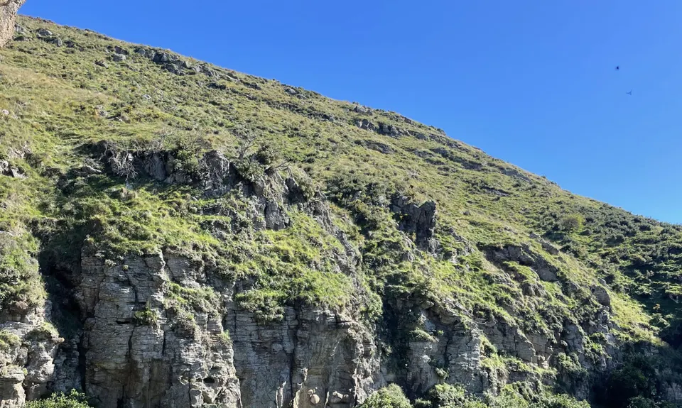
Carry on through several gates until you join the top section of Captain Thomas. Follow up to Evans Pass road and take the steps up the Mt Pleasant Bluffs track that follows the ridge to the Gun Emplacements. Jump the 'track closed' sign and work your way along the closed section of the Mt Pleasant Bluffs track. Careful footing required, but plenty of trees to act as hand holds. Pop out at Summit Road and follow this around onto the section closed to cars.

After approximately 400m of road we are squeezing behind the metal car barrier to your right and joining onto an obvious but unnamed track leading down the ridge into Scott's Valley. This is very steep, rocky, and slippery when wet so take care. Take a right onto the traversing track around Scott's valley and a little while after a farm gate, at a junction take a downwards leading track and follow past the old Heathcote Quarry.

At the next junction head upwards and along and then through a set of stairs that connect onto Kenton Track. Follow Kenton Track until you reach a stile onto Longridge Drive. Head down Longridge Drive and onto Mt Pleasant Road until you reach a bend with a sneaky little laneway (Cragieburn Lane) to your right and into Drayton Reserve Track. Follow the whole way down to McCormacks Bay.

Follow McCormacks Bay road, then Main Road until you reach Barnett Park. Grab water here from the fountain if needed. Stay to the right side of the field and head up the valley, taking the right most mown tracks until you reach another 'closed track sign'. Head up to the cave through some rocky sections and climb the stairs into the cave. Take care is this stairway has seen better days. Minus 5 points for not ascending to the cave.

Head back down the valley until you connect with Eastenders track and take this up until you hit the gravel road. Cross this directly and head up through tussock until you reach the Frog Pond mountain bike track. Take a left onto the track and follow until you reach Revalation Drive. Instead of crossing the stile, go downwards and around until you come to a gate that pops up through a reserve into Richmond Hill Road. Go straight across the road, through a pedestrian laneway and to the end of Richmond Hill Road. This is where the route takes a turn and heads off-piste. If you prefer, head down Richmond Hill Road and around till you connect to the start.

For those after a bit of nonsense, the goal is to head down between a set of bluffs through tussock and scrub until connecting back onto the Old Captain Thomas Track. Essentially you need to head down a gully and aim slightly up valley of a large single pine. Make sure there is the large bluff to the left and head down the notch between this large bluff and another to your right and towards the stand of ngaios. Be very careful and take this as slow as you need.
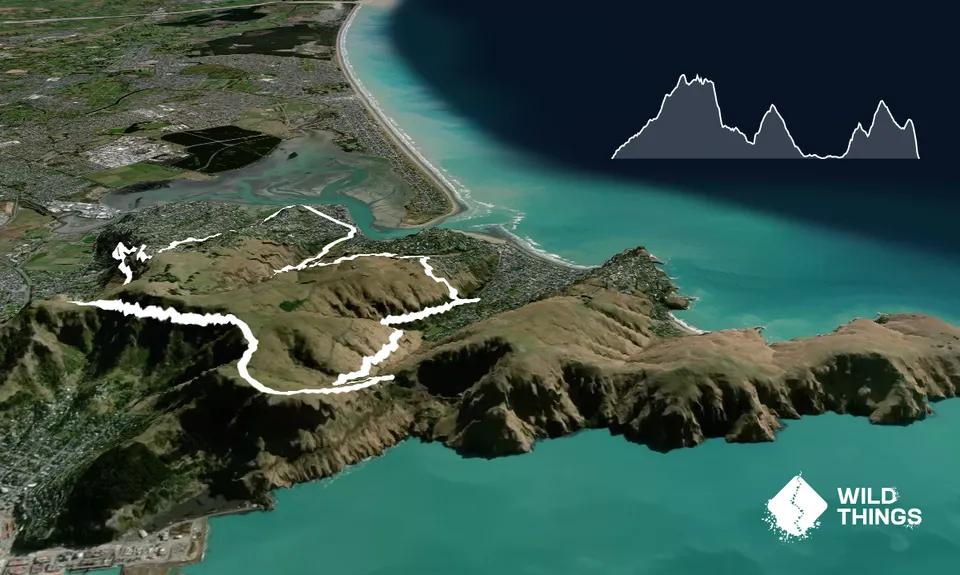
List of tracks below for reference: Old Captain Thomas (Closed) - Captain Thomas Mt Pleasant Bluffs-  Mt Pleasant Bluffs (Closed Section) - Summit Road Unnamed Track - Scott's Reserve Track (Closed) - Heathcote Quarry Track (Closed) - Kenton Track -  Longridge Drive/ Mt Pleasant Road - Drayton's Reserve Track - McCormacks Bay Road/ Main Road - Cave Track (Closed) - Eastenders Track - Frog Pond Track - Off-piste Scramble. 

Mt Pleasant Gun Emplacements. Old Heathcote Quarry.

Park down Paisley Street.

14 km

24 minutes

Unknown

No

Moderate.

Generally good.

Whistle, First aid kit, Extra food for emergencies, Cellphone, Map, Gaiters.

Fountain at Barnett Park.

Parts muddy after rain.

Bluffs in last section.

Trail Legend

Steve Hanmer

Steve Hanmer

has completed Boulder Dash twice in the last year.

Learn about Trail Legends.

You and Boulder Dash

As a VIP member you can record private notes for this trail, see all of your times and more.

Register Now

Already have an account? Login now

Trail Reviews

Well that was fun! A crafty combo of less-trodden trails, stitched together into a circuit with an "interesting" finish!
The "spring growth" that Tony mentioned is now a summer riot of all sorts of fun obstacles, but still passable - the hint about the gully and the lone pine tree (visible further down) was helpful.

Mike Steel

January 17, 2022

A superb loop linking well known trails and a couple of new buts for me- namely the Frog Pond trails.

I must endorse Brion in suggesting that those that aren't sure about the cliff bash at the end would be better to take the road down and round. The GPX is essential in picking the way down, and note as at Nov 2021 spring growth is well and truly adding to the difficulty of that last bit. Great if you are training for the Revenant of something similar though!

Tony Sharpe

November 8, 2021

PS. I plan to cut a proper route down through the scrub at the end - this route was submitted so long ago I forgot about it. Watch this space I suppose?!

Brion Matthews

November 6, 2021

Fun route! Grass was getting quite tall on Mt Pleasant Bluffs Track so take care. (I tripped onto some rocks in there, so I was glad to have a first aid kit in my pack.) The last bit of bush bashing is silly but quite entertaining.

Matt Halverson

November 6, 2021

Login to submit a review

Trail Running Community

Find people who are interested in or have completed this trail run.

You must register or login to view this feature.

Register Now

Overlapping Trails

These overlap with this trail to some degree. You may wish to combine them but please note that to qualify for FKTs on these runs you should record a separate activity for each.

Punk Rock Assault On Windsor Castle

Punk Rock Assault On Windsor Castle

Length: 12.0km

Level: Intermediate

Gang of Four

Gang of Four

Length: 15.7km

Level: Beginner - Intermediate

Trinity - Harbour Bruisin'

Trinity - Harbour Bruisin'

Length: 20.1km

Level: Intermediate

Gates Of The East

Gates Of The East

Length: 14.0km

Level: Beginner - Intermediate

Mt Pleasant Elevator

Mt Pleasant Elevator

Length: 11.8km

Level: Beginner - Intermediate

Beer Bum Bluffs

Beer Bum Bluffs

Length: 9.5km

Level: Intermediate

Other trails nearby
Port Hills Nearly Half Marathon

Port Hills Nearly Half Marathon

Length: 18.0km

Level: Intermediate - Experienced

Heathcote River Run - Opawa to Hoon Hay

Heathcote River Run - Opawa to Hoon Hay

Length: 9.2km

Level: Beginner

VKV challenge

VKV challenge

Length: 10.0km

Level: Intermediate

Springing Around Longhurst

Springing Around Longhurst

Length: 3.1km

Level: Beginner

Find more trails and peaks nearby