Last Updated: 21st Sep 2023

Intermediate

Save Trail Save

I've done it Done

Double Top

Christchurch, Canterbury

Submitted by Steve Hanmer

Last Updated: 21st Sep 2023

Intermediate

Save Trail Save

I've done it Done

Grunt Factor: 39

Gnarl Factor: 58

21.5km

1155m

1155m

919m


Login as a VIP to see driving directions, distance and time.

Trail Map

Type of Run

Front country - easily accessible

Loop

Very hilly

Native bush

Plantation/exotic forest

Open farmlands

Open tussock/grasslands

Run Makeup

10%
15%
25%
50%

Farm Road / 4WD Track

Easy Single Track

Moderate Single Track

Technical Single Track

Average Uphill Gradient: +10.5%

Average Downhill Gradient: -12.1%

Trailhead

Login as a VIP to see the trailhead information.

Estimated Times to Run

5:00

Slow

3:30

Moderate

2:30

Fast

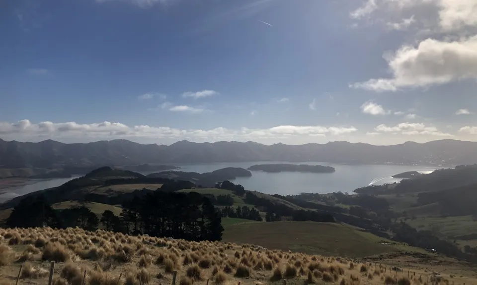
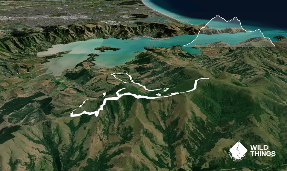
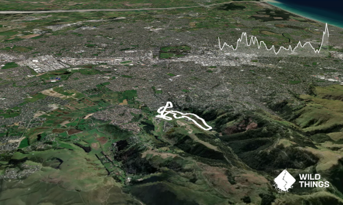
A chance to knock off the two highest named peaks on the Banks Peninsula in one concise loop; everyone prefers loops right?!

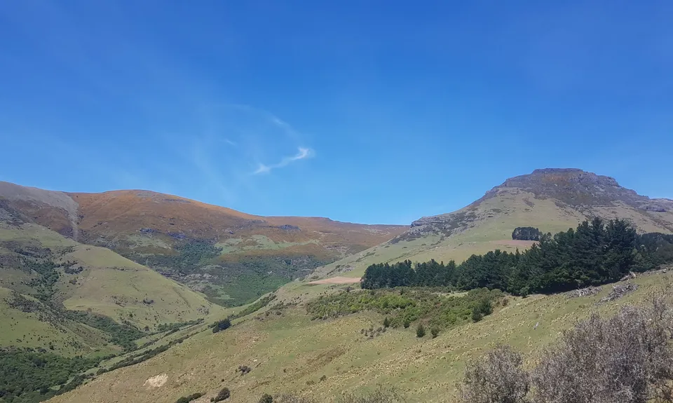
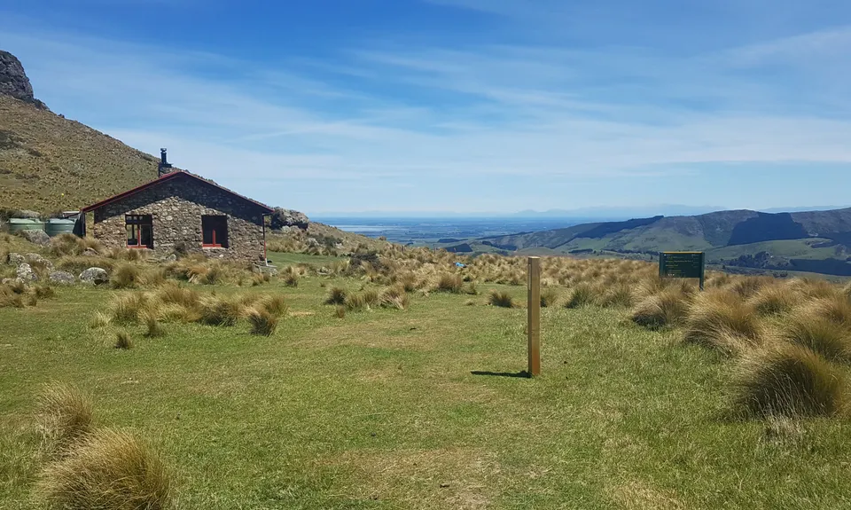
From the parking area follow the signs for Mt Herbert. It is fairly well signed all the way up the valley, although the markers get more spaced out towards the top of the valley. Work your way through the bush into more open farm terrain, which can get very hot on a sunny day. Eventually you will reach a junction at around 700m. Turn left here and head towards the summit of Mt Herbert past the Mt Herbert Shelter (a good place to respite if in need of a rest or shelte from the weather).

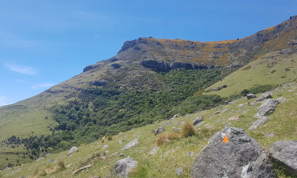
The trail is obvious along a wide 4WD track, with a marked turnoff just below the summit. Enjoy the views, and then head back the way you came, this time sticking to ridge and following the trail which heads around the back of Mt Bradley towards the Packhorse Hut. This is an interesting, technical, varied section of the trail.

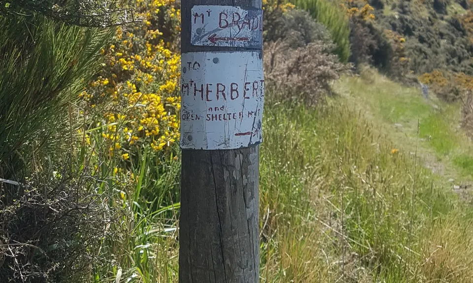
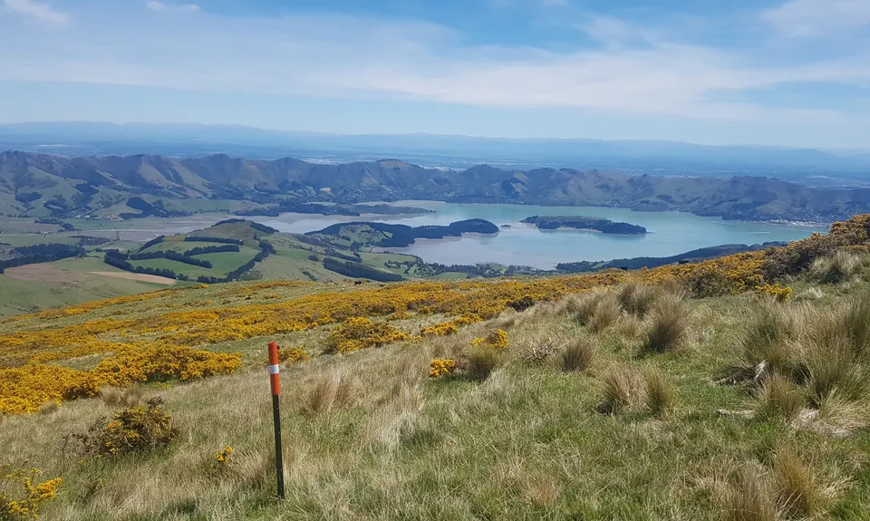
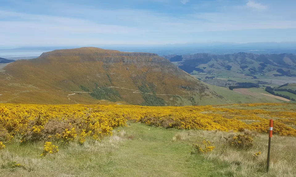
The turnoff to Mt Bradley summit is easy to miss, and is indicated by a marker post (see pics) which takes you up a steep grassy trail, winding through gorse to the summit. The summit itself is fairly uninspiring, but there are some views to be had on a clear day.

Head back the same way and rejoin the trail towards the Packhorse Hut; a chance to get some water/toilet here if required. From here head north around Mt Bradley; there is a marked track, although this section is not as well travelled as the rest of the route. The markers are sparse and the trail is technical/rocky and off-camber for the most part. Allow more time for this section than the map would suggest, as it can be slow going.

Eventually you will arrive back at the top of the Orton Bradley park and if you look closely you should be able to pick up the posts with light blue markings on the top (tablelands track), which will take you back to your car.

Lots of parking available. Generally a safe area looked after by a manager of the park.

26 km

41 minutes

Unknown

No

Moderate.

The turn off to Mt Bradley summit is not very obvious. Keep a close eye out for a very discreet marker post which indicates the turnoff up a vague trail to the summit.

Generally good.

Thermal leggings, Lightweight fleece top, Long-sleeved thermal top, Seam-sealed waterproof jacket, Gloves, Beanie/thermal headwear, Whistle, First aid kit, Extra food for emergencies, Cellphone, Map.

Water available at the Packhorse hut.

Not much shade if it's hot - take lots of water, and refill at the Packhorse hut if required.
The valley up to Mt Herbert from the start can get quite muddy after some rain.

Orton Bradley is a working farm, and as such contains a large number of animals. You are most likely to encounter cows at some point, so take care when passing these, especially if they have young calves with them.

Orton Bradley Cafe (if open)
http://www.ortonbradley.nz/cafe
Great spot to have a beer/coffee/ice cream after a solid workout in the hills.

Trail Legend

Kane Aitken

Kane Aitken

has completed Double Top once in the last year.

Learn about Trail Legends.

You and Double Top

As a VIP member you can record private notes for this trail, see all of your times and more.

Register Now

Already have an account? Login now

Trail Reviews

A wee cracker of a route with some very interesting and rugged tracks . Unfortunately you have to link up with some poorly maintained farm bits to make the loop. Definitely still worthwhile though and the tops are always a treat - even when visibility is low. The start of Faulkner Track is lovely and gives some fantastic views, but as Matt mentions it is quite rough going. I also had issues navigating through the farm land - I think some markers are missing, but if you follow your nose downhill you will eventually pick up another post with faded blue paint. This is also about the point that you are herded into a 'chute' that at the time of running was waist high grass and thistle.

Brion Matthews

February 9, 2022

The description is quite good except it didn’t mention just how much gorse there is! Also some patches of nettle so take care. Loved heading up Mt Bradley, have passed by the turnoff a few times but never gone up. (Glad I was prepared for the slightly underwhelming views!) The trail was quite technical after Packhorse Hut, falling away in places. The GPX doesn’t quite match reality around 18 km in — goes through what is now locked fenced paddock — but just keep following the markers and you’ll join back up further down. The final km is a fast finish, very fun!

Matt Halverson

May 22, 2021

Login to submit a review

Trail Running Community

Find people who are interested in or have completed this trail run.

You must register or login to view this feature.

Register Now

Overlapping Trails

These overlap with this trail to some degree. You may wish to combine them but please note that to qualify for FKTs on these runs you should record a separate activity for each.

Summit Walkway

Summit Walkway

Length: 34.0km

Level: Intermediate

Orton Bradley Loop

Orton Bradley Loop

Length: 10.0km

Level: Beginner

Orton Odyssey

Orton Odyssey

Length: 13.6km

Level: Beginner - Intermediate

Other trails nearby
Rapaki Sugarloaf Return

Rapaki Sugarloaf Return

Length: 15.0km

Level: Beginner - Intermediate

2 Sugars, 2 Vernons & a Half Shot

2 Sugars, 2 Vernons & a Half Shot

Length: 21.9km

Level: Beginner - Intermediate

The ATH (Around The Harbour)

The ATH (Around The Harbour)

Length: 61.4km

Level: Intermediate

Beer Bum Bluffs

Beer Bum Bluffs

Length: 9.5km

Level: Intermediate

Find more trails and peaks nearby