Last Updated: 8th Aug 2024
Ernie's Pukupuka Combined Loop
Last Updated: 8th Aug 2024
Open
Grunt Factor: 34 ?
Gnarl Factor: 38 ?
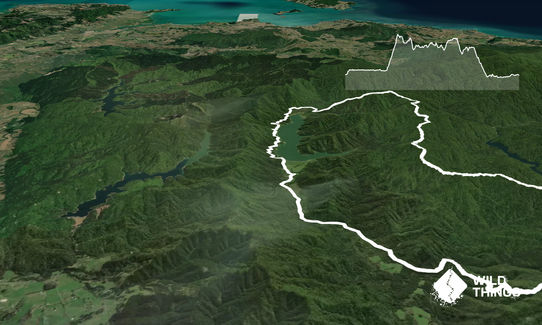
23.5km
1130m
1130m
510m

Last Updated: 8th Aug 2024
Last Updated: 8th Aug 2024
Open
Grunt Factor: 34 ?
Gnarl Factor: 38 ?
23.5km
1130m
1130m
510m
Front country - easily accessible
Loop
Undulating, some big hills
Native bush
Plantation/exotic forest
Open ridges/tops
Gravel Road
Easy Single Track
Moderate Single Track
Technical Single Track
Average Uphill Gradient: +9.5%
Average Downhill Gradient: -9.5%
VIP Feature: Send this route to your Garmin account so you can follow the course on your Garmin device.
Login as a VIP to see the trailhead information.
5.15:00
Slow
4.00:00
Moderate
3.00
Fast
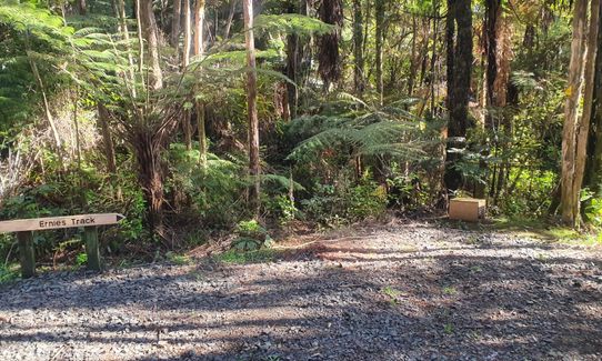
Starting From Upper Mangatawhiri campsite, head along the gravel road past the toilet block. Follow this road for about 3km running alongside the dam. Ernie's Track is on the left. It is technical in a lot of places, with a couple of stream crossings and with a steep climb up to 500m.
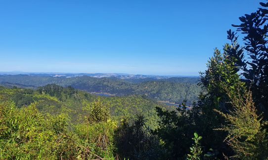
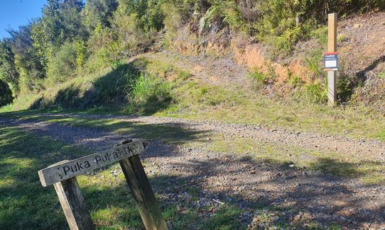
Here you will get great views of the multiple Hunua Dams. The trail then opens up slightly as you head down towards Lilburne Road. You pop out of the first bush section at Piggots campsite where there is a hut with a toilet and water tap. Head up the hill and continue along the road for about 2km until you join the Pukupuka Track on your right.
You are back into more technical track and climbing. As you run out of the bush and are back on the gravel road, turn right. There is a long downhill (12% gradient) to open up and get out some lactic build-up before an easy 5km along a gravel road finishing off where you started.
This trail includes the peak Pukapuka.
The track takes in great views of multiple dams along the way.
If you know of any public toilets near the trail start or on the route, please login and then let us know so we can update this section.
Parking is readily available at the campground, access is along Gravel Road.
0 km
0 minutes
No
No
Easy.
Very patchy.
Whistle, First aid kit, Extra food for emergencies, Cellphone, Map
Water is available in two creek crossings in the first half and a tap is available at a hut halfway through the loop.
Rain can bog down some of the more technical sections, so expect slow going in winter. Great cover most the way In the summer heat.
Trail Legend
Login as a VIP to become a Trail Legend. Learn about Trail Legends.
Fastest Known Times (FKTs)
You and Ernie's Pukupuka Combined Loop
As a VIP member you can record private notes for this trail, see all of your times and more.
Already have an account? Login now
Brilliant loop, trails were pretty soggy and rooty but really fun. Didn't help it was the weekend after Xterra. Poles are very helpful.
June 18, 2024
JU
Great run, some technical parts! Great views at times! GPX has a portion unit that is off track, so your run may not record.
May 15, 2022
Another great run in the Hunua's. Pukapuka track slight more vegetated than Ernie's track so power hiked a bit more of this section. Not much mud to contend with yet either.
April 28, 2022
These overlap with this trail to some degree. You may wish to combine them but please note that to qualify for FKTs on these runs you should record a separate activity for each.
Send to your phone
Scan the below QR code to open this trail on your phone.

Tip: position the QR code in your phone camera screen.


