Last Updated: 25th Jun 2025
Riverhead Gates Challenge
Last Updated: 25th Jun 2025
Open
Grunt Factor: 59 ?
Gnarl Factor: 9 ?
67.0km
1600m
1600m
130m
Last Updated: 25th Jun 2025
Last Updated: 25th Jun 2025
Open
Grunt Factor: 59 ?
Gnarl Factor: 9 ?
67.0km
1600m
1600m
130m
Front country - easily accessible
Loop
Undulating, some big hills
Dog Friendly
Native bush
Plantation/exotic forest
Gravel Road
Easy Single Track
Average Uphill Gradient: +3.9%
Average Downhill Gradient: -4.2%
VIP Feature: Send this route to your Garmin account so you can follow the course on your Garmin device.
Login as a VIP to see the trailhead information.
10:00
Slow
8:00
Moderate
6:00
Fast
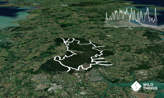
This is a run with a difference! While a route and gpx file are provided there are multiple ways you can attack this challenge. The goal is simple - visit each and every gate within the forest boundaries - there are 17 of them. Where you start, what order you do them in, and how you get between them is entirely down to you. Good luck!
NOTE: we suggest you take a gps map app with you as there are so many trails it is easy to get lost. There is no water on course, so take your entire supply with you. Also plenty of food.
There are many trails intertwining throughout this pine forest. Ideal for bikes, both pedal and motor, runners, walkers and horses and dogs. So the trails can be very busy at times. Some good climbs, and is notoriouosly muddy during winter - so go then you have more fun.
If you know of any public toilets near the trail start or on the route, please login and then let us know so we can update this section.
Plenty of room to park at the entrance way. If this carpark is full, there are a few entrances to the forest nearby you could park and walk back to the start of Barlow Road.
36 km
34 minutes
Yes
No
Easy.
Take a map app with you such as maps.me or trailforks
Very patchy.
Short-sleeved thermal top, Long-sleeved thermal top, Seam-sealed waterproof jacket, Gloves, Beanie/thermal headwear, Whistle, First aid kit, Extra food for emergencies, Cellphone, Map
No water on course.
Extremely muddy on trails during the winter months. Summer there is little to no water in streams.
Boric Food Market
Coatsville Riverhead Highway on the corner
Hallertau Brewery
Riverhead
Fastest Known Times (FKTs)
You and Riverhead Gates Challenge
As a VIP member you can record private notes for this trail, see all of your times and more.
Already have an account? Login now
Last years storms, and logging have meant that the trails have changed significantly. I broke this into a couple of outings and relied heavily on Trail Forks. There is also an additional, hard to access, gate in the SW corner not covered by the above map, but I won't tell anyone if you don't...
July 1, 2024
TZ
Probably the best way to explore the trails of Riverhead forest.
A solid topo map and/or a gpx file is recommended.
Certainly lives up to its name of being a "Challenge"!
July 25, 2021
These overlap with this trail to some degree. You may wish to combine them but please note that to qualify for FKTs on these runs you should record a separate activity for each.
Send to your phone
Scan the below QR code to open this trail on your phone.

Tip: position the QR code in your phone camera screen.


