Last Updated: 8th Oct 2024
Simple Beauty
Last Updated: 8th Oct 2024
Open
Grunt Factor: 12 ?
Gnarl Factor: 21 ?
8.0km
310m
310m
253m
Last Updated: 8th Oct 2024
Last Updated: 8th Oct 2024
Open
Grunt Factor: 12 ?
Gnarl Factor: 21 ?
8.0km
310m
310m
253m
Front country - easily accessible
Combo
Undulating, some big hills
Native bush
Coastal
Volcanic
Farm Road / 4WD Track
Easy Single Track
Moderate Single Track
Average Uphill Gradient: +7.6%
Average Downhill Gradient: -7.6%
VIP Feature: Send this route to your Garmin account so you can follow the course on your Garmin device.
Login as a VIP to see the trailhead information.
1:40
Slow
1:10
Moderate
0:45
Fast
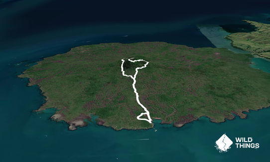
This route is a simple beginner's introduction to Rangitoto that takes you through the most beautiful glades on the island while including a summit, and minimising time on the vehicle tracks.
From the starting point, follow the Summit Track. After exactly a mile you'll branch onto Wilson's Park track on the left. There's a small bit of technical running here across scoria although this eases. After another mile on the track you'll come to down a short series of steps to a vehicle road which you follow uphill to you right. After a couple of hundred meters this reaches a clearing where the road descends in front of you. To the slight right is access to a boardwalk, and further to the right of that access to another track. Take this track which will lead you up the steepest section of this route to the summit rim and keeping right the whole way you will eventually reach the summit trig and viewing platform where you can stop to take in the view, water, and food!
Crossing the platform, descend the stairs until you come to another junction with trails to the left and right, and directly ahead a boardwalk that you'll descend. This will take you back to where you started the summit ascent from the vehicle road. You'll now follow the vehicle track to your right down the hill - but don't get too carried away with a fast descent, as in 400m there's a branch track to your right you'll be taking.
Follow this narrow rocky track for another 400 meters, until you come to join a wider gladed track. To your left (not included in the route plot) is a small there-and-back diversion option to the lava caves. Taking the right will lead you to a large glade, and taking the trail off this to the left will lead you back down the summit track and past where you entered Wilson's Park Track. Follow the summit track down back downhill towards the start. Near there a track is marked on the right for Kowhai Grove - follow this until you come to a vehicle track, then take a left and you have a short section of road to the end.
This trail includes the peak Rangitoto.
Emerging from the sea just 600 years ago, pest-free Rangitoto Island is the youngest volcano in New Zealand. An Auckland icon and deeply enriched with history, it's long been a favourite day trip for walkers. Experience a unique volcanic landscape amongst tui and tieke (saddleback).
If you know of any public toilets near the trail start or on the route, please login and then let us know so we can update this section.
Access to Rangitoto is by Fuller's ferry from Auckland CBD.
0 km
0 minutes
No
No
Easy.
The only place to be careful is in taking the right turn off the vehicle road as you descend after visiting the summit. This track is signposted but is a minor one and might be easy to miss if you belt down the road.
Generally good.
Short-sleeved thermal top, Windproof jacket, Whistle, First aid kit, Extra food for emergencies, Cellphone, Map
There is no water available on Rangitoto so it is important to carry your own. In summer the island is a lot hotter and drier than other parts of the region and you will need more water than usual.
Rangitoto can be very hot and dry in summer. No water is available on the island, so it is important to take your own.
Trail Legend
Login as a VIP to become a Trail Legend. Learn about Trail Legends.
Fastest Known Times (FKTs)
You and Simple Beauty
As a VIP member you can record private notes for this trail, see all of your times and more.
Already have an account? Login now
These overlap with this trail to some degree. You may wish to combine them but please note that to qualify for FKTs on these runs you should record a separate activity for each.
Send to your phone
Scan the below QR code to open this trail on your phone.

Tip: position the QR code in your phone camera screen.


