Last Updated: 21st Sep 2023
The Taipo
Submitted by Katie Smith
Last Updated: 21st Sep 2023
Open
Grunt Factor: 18 ?
Gnarl Factor: 16 ?
17.5km
350m
350m
293m
Last Updated: 21st Sep 2023
Submitted by Katie Smith
Last Updated: 21st Sep 2023
Open
Grunt Factor: 18 ?
Gnarl Factor: 16 ?
17.5km
350m
350m
293m
Front country - easily accessible
Out and Back
Undulating, small hills only
Dog Friendly
Native bush
Riverside
Open farmlands
Farm Road / 4WD Track
Easy Single Track
Technical Single Track
Average Uphill Gradient: +5.6%
Average Downhill Gradient: -5.8%
VIP Feature: Send this route to your Garmin account so you can follow the course on your Garmin device.
Login as a VIP to see the trailhead information.
3:00
Slow
2:15
Moderate
1:30
Fast
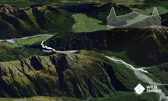
This is a nice accessible out-and-back with a good solid hill to start with, and can be extended as far as you want along the Taipo Valley - the track continues for approximately 30km to Harman Pass. Although the majority of the route is a 4WD track it tends to be muddy and slippery, particularly after rain.
From the car park the 4WD track climbs steadily over a high terrace before dropping back down to the flat river valley ahead. You will go through a gate on the way down. Cross a creek at the bottom.
From the flats the track follows the river upstream through a mix of gorse and native bush. There are several side creeks to cross, which can be impassable after heavy rain. After about 2km of flats you reach the first ford - if the river is high, backtrack 100m and look for the orange triangle marking a high sidle through the bush - even if the river is passable it makes a nice change from the 4WD track.
Dillon Hut is reached after about 8.5km, with a historic hut as well to have a look at.
Turn around here and head back down the valley then way you came.
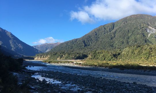
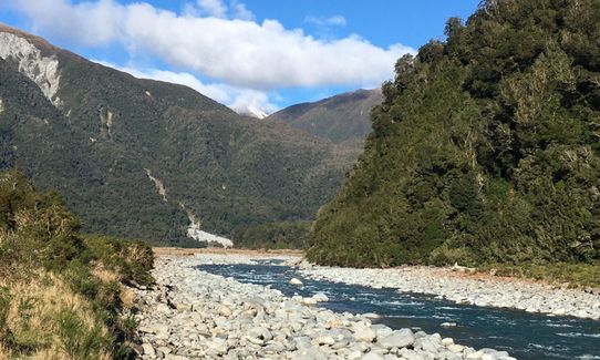
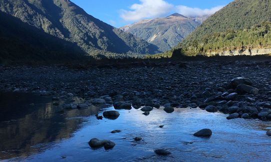
Stunning views up the Taipo Valley
If you know of any public toilets near the trail start or on the route, please login and then let us know so we can update this section.
Plenty of parking, no public transport.
42 km
36 minutes
Yes
No
Easy.
Non-existent.
Long-sleeved thermal top, Seam-sealed waterproof jacket, Gloves, Beanie/thermal headwear, Whistle, First aid kit, Extra food for emergencies, Cellphone, Map
Plenty available from the river and side creeks.
In winter the valley doesn't get much sun, making it surprisingly cold, and hard frosts can last all day. It gets very muddy after rain.
Best avoided if rivers are flooding - have a look at the Taipo from the road bridge near the start, the river is usually blue and clear.
Theatre Royal Hotel (aka the Kumara pub)
Kumara
Good coffee, excellent food and a nice atmosphere, and they don't mind soggy muddy runners.
Trail Legend
Login as a VIP to become a Trail Legend. Learn about Trail Legends.
Fastest Known Times (FKTs)
You and The Taipo
As a VIP member you can record private notes for this trail, see all of your times and more.
Already have an account? Login now
Send to your phone
Scan the below QR code to open this trail on your phone.

Tip: position the QR code in your phone camera screen.


