Last Updated: 21st Jan 2025
Avalanche Peak - Crow River
Last Updated: 21st Jan 2025
Open
Grunt Factor: 44 ?
Gnarl Factor: 87 ?
20.0km
1150m
1270m
1833m
Last Updated: 21st Jan 2025
Last Updated: 21st Jan 2025
Open
Grunt Factor: 44 ?
Gnarl Factor: 87 ?
20.0km
1150m
1270m
1833m
Front country - easily accessible
Point to Point (one way)
Mountainous
Native bush
Riverside
Open tussock/grasslands
Open ridges/tops
Moderate Single Track
Technical Single Track
Untracked / Route only
Average Uphill Gradient: +17.80%
Average Downhill Gradient: -11.90%
VIP Feature: Send this route to your Garmin account so you can follow the course on your Garmin device.
Become a VIP Member to see the trailhead information.
4:30
Slow
3:20
Moderate
2:45
Fast
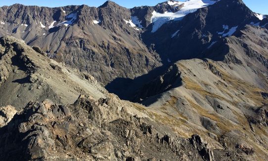
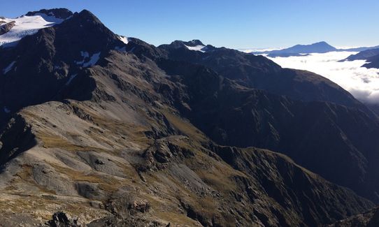
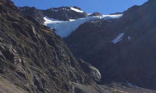
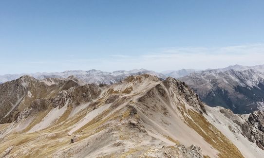
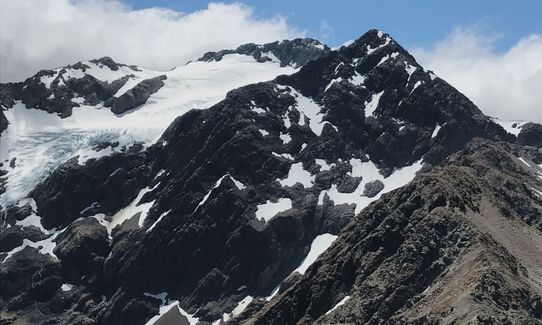
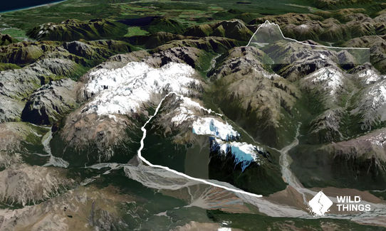
This spectacular route follows the original/classic (but now defunct) "Avalance Peak Challenge" mountain race. It starts with a grunty 1000+ m ascent of the popular Avalanche Peak then heads along the connecting ridge towards Mt Rolleston before dropping off down a 500 m scree slide into the Crow River, which gives pleasant travel out to the big Waimakariri Valley and back to a bike at Klondyke Corner, for the return to the village. The original race used to also include a 2km warm-up around the village and a long trudge down to the Bealey pub so was a bit longer than the 20km route described here (the winning time for this longer trip was often under 2 hours 30 mins).
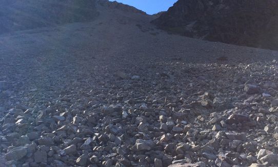
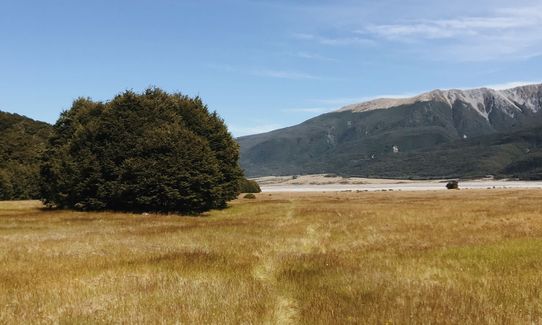
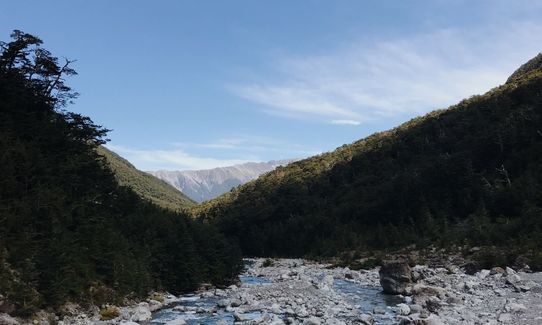
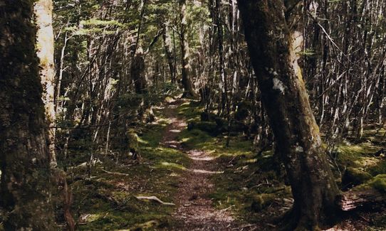
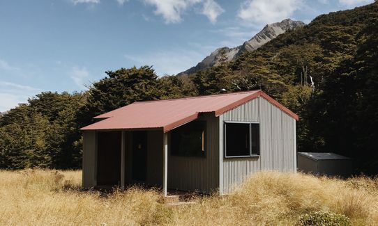
First drop a bike somewhere near Klondyke Corner (e.g. up the side road on the Arthur's Pass side of the Waimakariri bridge) and drive to the village. Set off up the Avalanche Peak track which winds up steeply through the forest by Avalanche Creek and its waterfalls (don't expect to run this part!) and then levels out a little higher up, before a final push to the summit (this may take only a little over 1 hour from the start). From the summit you are going to run along the connecting ridge towards Mt Rolleston - you can either approach it directly (take care leaving the summit area) or descend south and pick up a trail that winds around the south side of Avalanche Peak. You then follow faint trails that descend and sidle left-wards toward the connecting ridge which has no poles or markers (except the poles that indicate where to drop off). It is very important that you do not take the first or second scree slide into the Crow (they are badly bluffed) - fortunately large rock arrows have been built on the ground to ensure you continue on towards Mt Rolleston, over a couple of bumps, till you reach two obvious poles and where for the first time you can see a wide expanse of scree that goes all the way to the valley floor. Faint trails guide you down this big slide which is of variable quality (take care in the thin section half-way down). At the bottom cross to the true right of the valley which leads down valley (with a shortcut to the true left before returning to the true right) until Crow Hut is reached, which is a nice place for a stop. From there the trail stays on the true right of, and always near the Crow river; it's a little slow in places but pleasant running in the sections of bush, and becomes easier further down valley. A prominent marker indicates where you cross to the true left of the Crow River - follow markers which eventually lead you through bush and onto spacious and cruisey alpine pastures that follow down the left side of the Waimakariri River. Eventually you'll need to leave this blissful grassy travel and start running on more demanding river stones with occasional crossings of the braided main river, just head for Klondyke Corner, picking up more runnable lines where you can, most likely taking you past the toe of Turkey Flat and out to the start of the side road where your bike is waiting.
This trail includes the peak Avalanche Peak.
Waterfalls, glaciers, bush, ridges, rivers, and a big scree slide.
If you know of any public toilets near the trail start or on the route, please login and then let us know so we can update this section.
Plenty of parking and safe. Turn side-mirrors in (Keas have a new game: let's try and remove the side mirror from its casing).
1 km
2 minutes
No
No
Moderate.
It's important to be aware that the first two scree slides into the Crow on the connecting ridge between Avalanche Peak and Mt Rolleston end in bluffs (tourists have come to grief here) - continue until you reach two poles (the only poles on that ridge) that indicate the correct scree-slide descent.
Keep a keen eye out for good lines down the scree - there's a faint central trail at the top and bottom of the scree but it tends to get a bit lost in the middle - some runners in the AP challenge race also used to have success in keeping left, especially near the bottom.
It's hard to get lost otherwise - from the summit of Avalanche peak you are basically following two valleys downward, that lead back to the road.
Patchy.
Long-sleeved thermal top, Seam-sealed waterproof jacket, Gloves, Beanie/thermal headwear, Personal Locator Beacon (PLB), Whistle, First aid kit, Extra food for emergencies, Survival blanket, Cellphone, Map
No water from the start till the Crow river (carry at least 1 litre from the the start); endless water from the Crow river onwards.
Viable as a run only when Avalanche Peak is clear of snow (typically, early summer to late Autumn), and when the Waimakariri/Crow rivers are not running high.
Take care on the big scree descent (during the race there used to be a medical tent at the bottom to tend to the injured!). Bike gloves can help protect your palms if you slip over going down.
Do you have a suggestion on where to go afterwards for the best coffee / cake / breakfast / brunch / beer?
Trail Legend
Login as a VIP to become a Trail Legend. Learn about Trail Legends.
Fastest Known Times (FKTs)
You and Avalanche Peak - Crow River
As a VIP member you can record private notes for this trail, see all of your times and more.
Already have an account? Login now
Wonderful adventure. Bit more of a hike/wog for this ol bird! Scree not as soft as we hoped so slow going but wonderful views along the tops and lovely track running out from Crow Hut. Well worth a visit!
January 31
Seriously cool run! Big views, fun scree, ice cold river water to drink, sections of beech forest, some grassy plains, and some river bed running. Get amongst!
January 15, 2019
These overlap with this trail to some degree. You may wish to combine them but please note that to qualify for FKTs on these runs you should record a separate activity for each.
Send to your phone
Scan the below QR code to open this trail on your phone.

Tip: position the QR code in your phone camera screen.
Plan smarter, stay motivated, track your progress, and unlock the full Wild Things experience — while saving along the way.


