Last Updated: 21st Sep 2023
Coal Crown Arrowtown
Last Updated: 21st Sep 2023
Open
Grunt Factor: 34 ?
Gnarl Factor: 51 ?
17.0km
1130m
1490m
1733m
Last Updated: 21st Sep 2023
Last Updated: 21st Sep 2023
Open
Grunt Factor: 34 ?
Gnarl Factor: 51 ?
17.0km
1130m
1490m
1733m
Front country - easily accessible
Point to Point (one way)
Mountainous
Native bush
Open tussock/grasslands
Open ridges/tops
Farm Road / 4WD Track
Easy Single Track
Moderate Single Track
Technical Single Track
Untracked / Route only
Average Uphill Gradient: +17.2%
Average Downhill Gradient: -14.6%
VIP Feature: Send this route to your Garmin account so you can follow the course on your Garmin device.
Login as a VIP to see the trailhead information.
4:00
Slow
3:00
Moderate
2:00
Fast
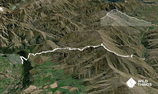
Starting at the Coal Creek fence stile - 9km from Cardrona township on the right-hand side - cross the stile and start heading up the overgrown 4wd track. There will be no markers for a few kms and it's a grunty little start. Follow the 4wd track until it basically ends and you see an orange pole. From here you veer left and start heading towards the main ridge above you.
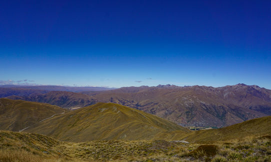
The poles are there as a guide but I found it easier to find my own route near the poles - the poles are there basically for direction and there is lots of growth. Be wary of all the rosehip! Ouch. Follow the poled route up over and through all the slippery head high tussock, this is the steepest part of the climb. You will head up a ridge that connects with the main ridge, where you start to see some views down towards the Crown Range carpark. Follow the poles and signs, you will veer right and the main ridge will take you to the summit of Crown Peak. Good spot here or on top of the rocks to the right for a little break before descending - it's a long descent so enjoy the break.
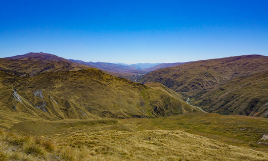
Follow the signs in the little saddle just after the trig point for Crown Peak and turn left down the well formed track. This is now almost downhill for 12km or so. You will zig zag your way down to a little valley, follow the signs to Glencoe Station around the back of Mt Beetham. From here you will start having a few choices of trails to take down to Arrowtown. I chose the Tobins track route as it was the quickest and I was short on time. Follow the signs carefully and tracks as quite a few are overgrown heading over to connect with Tobins. The trail finishes at the back of Arrowtown at the Tobins Track bridge or if you are warm - swim in the river.
This trail includes the peak Crown Peak.
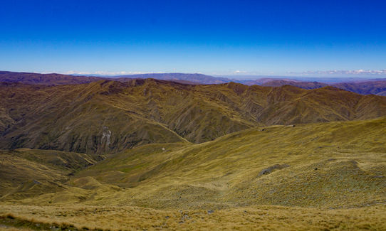
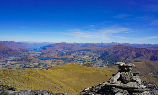
Brilliant 360 degree views once on the ridge towards Crown Peak.
If you know of any public toilets near the trail start or on the route, please login and then let us know so we can update this section.
If travelling from Wanaka there is a little pull-in/carparking area on the right-hand side of the road 9km past Cardrona township. Be very careful crossing the road here as cars travel fast through the Crown Range.
21 km
24 minutes
Unknown
No
Moderate.
Just make sure you follow the poles, signs and use common sense.
Generally good.
Long-sleeved thermal top, Seam-sealed waterproof jacket, Gloves, Beanie/thermal headwear, Personal Locator Beacon (PLB), Whistle, First aid kit, Extra food for emergencies, Survival blanket, Cellphone, Map, Headtorch and spare batteries, Crampons / microspikes (for winter conditions), Gaiters
None! Take all your water. Unless there has been plenty of rain and creeks have formed.
Winter would be tough if snow/ice is present. I wouldn't recommend it.
Plenty of Rosehip in the beginning, the odd spikey spaniard.
Fork N Tap
Arrowntown
http://www.theforkandtap.co.nz/
Good food and beer - plenty of beer!
Arrowtown Bakery
Arrowtown
http://www.arrowtown.com/things-to-do/eat-and-drink/eat-drink-business-listings/view/arrowtown-bakery
Good coffee and pies of course!
Fastest Known Times (FKTs)
You and Coal Crown Arrowtown
As a VIP member you can record private notes for this trail, see all of your times and more.
Already have an account? Login now
These overlap with this trail to some degree. You may wish to combine them but please note that to qualify for FKTs on these runs you should record a separate activity for each.

Length: 39.0km
Level: Intermediate - Experienced
Send to your phone
Scan the below QR code to open this trail on your phone.

Tip: position the QR code in your phone camera screen.


