Last Updated: 19th Mar 2026
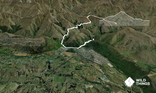
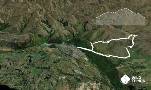
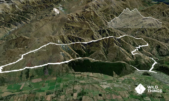
The Not WILD 20 Mile Course
Last Updated: 19th Mar 2026
Open
Grunt Factor: 71 ?
Gnarl Factor: 59 ?
35.5km
1800m
1800m
1456m
Last Updated: 19th Mar 2026
Last Updated: 19th Mar 2026
Open
Grunt Factor: 71 ?
Gnarl Factor: 59 ?
35.5km
1800m
1800m
1456m
Back country - remote
Loop
Very hilly
Open ridges/tops
Volcanic
Sealed Road
Moderate Single Track
Untracked / Route only
Average Uphill Gradient: +13.70%
Average Downhill Gradient: -13.70%
VIP Feature: Send this route to your Garmin account so you can follow the course on your Garmin device.
Become a VIP Member to see the trailhead information.
Not suitable
Slow
6:00
Moderate
4:00
Fast
This is the full 20 mile course other than the 3k of MTB trails after Coronet Peak Ski Area. These trails are off limits and instead you will need to run around 3k of sealed road downhill from the ski area.
Most suitable for:
Intermediate level runners who are comfortable on technical terrain. The section from Big Hill Saddle over Brow Peak to Coronet Peak Ski Area is off-track (navigation tricky if the cloud is down) and there are a couple of steep drop-offs. Do not attempt if you are not confident with heights. A high level of fitness required.
Navigation:
Easy on the tracked sections. Reasonably straightforward along the Brow Peak ridge in clear visibility but tricky if the cloud is down.
Peaks to be bagged:
Brow Peak 1456m
Trail Conditions:
Lots of easy to moderate single track and a smattering of sealed road, but the sting in the tail is the long section of rough, sketchy trail over the Brow Peak ridge.
This trail includes the peak Brow Peak.
If you know of any public toilets near the trail start or on the route, please login and then let us know so we can update this section.
Plenty of parking.
0 km
0 minutes
Unknown
No
Moderate.
Easy on the tracked sections. Reasonably straightforward along the Brow Peak ridge in clear visibility but tricky if the cloud is down.
Unknown.
Thermal leggings, Long-sleeved thermal top, Seam-sealed waterproof jacket, Beanie/thermal headwear, Personal Locator Beacon (PLB), Whistle, First aid kit, Extra food for emergencies, Survival bag, Cellphone, Compass, Map
There is limited drinking water on the route. We recommend setting off with at least 1 litre of fluid and topping up to at least 1.5L at the final stream crossing before Big Hill Saddle (in the beech forest) and again at Coronet Peak Ski Area.
Do you have a suggestion on where to go afterwards for the best coffee / cake / breakfast / brunch / beer?
Trail Legend
Login as a VIP to become a Trail Legend. Learn about Trail Legends.
Fastest Known Times (FKTs)
You and The Not WILD 20 Mile Course
As a VIP member you can record private notes for this trail, see all of your times and more.
Already have an account? Login now
Awesome route, but definitely not 2400m climb and descent in the description - more like 1600m. Best done in summer and autumn - snow and ice in winter and spring could make things tricky along the ridgeline from Big Hill Saddle to Coronet.
November 18
stunning ridgelines.
There is a degree of commitment and consequence on this route, but travel along the ridgeline is generally non-technical.
December 16, 2024
DO NOT attempt this run on anything less than a perfect day! I consider myself an intermediate runner, and I read the description for this run anticipating a run that would strech me, and was aware that some portion of this trail is "off trail". The ridge section is very exposed and in wet conditions the slate rock would be exceptionally slippery. There are a number of very steep drop offs, and while I don't consdier myself scared of heights, I was uncomfortable on several "sketchy" sections where climbing slate rock was required for about 5 meters vertical, however my comrad and I felt safer taking a side approach that required taking handfuls of tussock up 10m vertical to where we could only assume the track continued. The 3km section before the coronet ski feild is essentially no trail navigation, and was extremely slow going as some of the slate rock is disintegrating, there is no discernable track for much of it, we were trusting the navigation on our watches and eventually made it to the skifeild - howevere I would rate this as not for the faint of heart, and i probably wouldn't do it again. It very definitely stretched me into my uncomftable zone. I am exceptionally happy that I have completed it, however I completed it on a perfect day with only light winds. Had this been in any way a less than perfect day more experienced me would have told less experienced me that doing this trail is a bad idea if even remotely wet/cold or windy. MAKE SURE that you have uploaded the GPX file to your watch and that you have your track deviation notifications on as it is very easy to end up off course as there are a nuumber of cases where the trail you take for this run are not obvious and we continued on the more obvious trail for several minutes before realising we were off course several times.
Ultimately, if you have never done a course that goes "off trail" and requires navigation, you will likely be better off not attemptong this trail. We had a blast and enjoyed ourselves, but wanted to make sure that no one attempts this course unprepared for what lies ahead!
March 10, 2024
These overlap with this trail to some degree. You may wish to combine them but please note that to qualify for FKTs on these runs you should record a separate activity for each.

Length: 39.0km
Level: Intermediate - Experienced
Send to your phone
Scan the below QR code to open this trail on your phone.

Tip: position the QR code in your phone camera screen.
Plan smarter, stay motivated, track your progress, and unlock the full Wild Things experience — while saving along the way.