Last Updated: 21st Sep 2023

Beginner - Intermediate

Save Trail Save

I've done it Done

Around Ben Lomond

Queenstown, Otago

Submitted by Matthew Pester

Last Updated: 21st Sep 2023

Beginner - Intermediate

Save Trail Save

I've done it Done

Grunt Factor: 39 ?

Gnarl Factor: 23 ?

33.5km

1480m

1480m

1312m


Login as a VIP to see driving directions, distance and time.

Trail Map

Type of Run

Front country - easily accessible

Loop

Very hilly

Native bush

Lakeside

Open farmlands

Open tussock/grasslands

Open ridges/tops

Run Makeup

30%
15%
25%
5%
15%
10%

Sealed Road

Gravel Road

Farm Road / 4WD Track

Easy Single Track

Moderate Single Track

Technical Single Track

Average Uphill Gradient: +10.2%

Average Downhill Gradient: -9.4%

Trailhead

Login as a VIP to see the trailhead information.

Estimated Times to Run

6:30

Slow

4:30

Moderate

3:25

Fast

Starting at the Sunshine bay bus stop, run up Fernhill Road and over the top back into Fernhill. Take a left at Wynyard Crescent and up to the first hard left turn.

From here you will see a dirt carpark on your right. You will see a very narrow overgrown single track at the end of this small car park. Head down it for 50m. It opens up to a gravel track on your left. Follow it over a bridge and up to the bike park, then go down to your right. Follow this track over another bridge until it gets to Thompson Street. Head down Thompson Street and hang a left on Lomond Crescent.

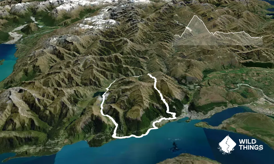
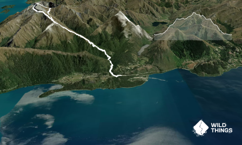
Up over the rise and on your right you will see a dirt road. This is the Skyline Access Road. Head up to the midway clearing. At the midway clearing head right following the Skyline access road (4wd track) until you see a sign in front/ to the left of you. Head up here (Ben Lomond Track) 97% of the way to Ben Lomond Saddle.

You will see a sign 300m before the seat at the saddle (note if you've gone too far) that says Moonlight Track to the right. Take this route up and over for around 4.5km down. Some is steep, some is narrow, some is boggy. All is epic for views! Jump the fence here and go left on the Moke Lake Farm Road (4wd road). In 8km time you reach Moke Lake and the campground (water refill if need be).

Follow the road for another 9km until you get to the Glenorchy Road. Go left back towards Queenstown for 3.7km. After you get to the top of a road hill go left back up Fernill (Sunshine Bay) Road to the bus stop in 0.5km. Rest, Eat, Beer!

All the views!

Lots of residential parking

4 km

7 minutes

Unknown

No

Moderate.

Patchy.

Thermal leggings, Lightweight fleece top, Long-sleeved thermal top, Seam-sealed waterproof jacket, Windproof jacket, Gloves, Beanie/thermal headwear, Whistle, First aid kit, Extra food for emergencies, Survival blanket, Cellphone, Map

22.5km in there is water available at the Moke Lake campsite

Ice and Snow. If unsure see DOC.

Trail Legend

Michael Jones

Michael Jones

has completed Around Ben Lomond 3 times in the last year.

Learn about Trail Legends.

You and Around Ben Lomond

As a VIP member you can record private notes for this trail, see all of your times and more.

Register Now

Already have an account? Login now

Trail Reviews

Definitely a big day out. Great loop around Big Ben that takes in part of the moonlight track to Moke lake. Good training run for some of the trail races in town.

Chris Seymour

October 24, 2021

An absolutely brutal beauty of a run. I tend to run this in the reverse direction, getting the road running out of the way while my legs are still fresh - but that gives a much tougher climb up to the saddle when the time comes. This would be perfect training for Kepler or Routeburn. Tough all the way and well worth the hard work!

Fleur Douglas

January 31, 2020

Login to submit a review

Trail Running Community

Find people who are interested in or have completed this trail run.

You must register or login to view this feature.

Register Now

Overlapping Trails

These overlap with this trail to some degree. You may wish to combine them but please note that to qualify for FKTs on these runs you should record a separate activity for each.

One Mile - Gondola Scenic Route

One Mile - Gondola Scenic Route

Length: 9.3km

Level: Beginner - Intermediate

Moonlighting around Bowen Peak

Moonlighting around Bowen Peak

Length: 24.0km

Level: Beginner - Intermediate

Other trails nearby
Mt. Crichton Loop

Mt. Crichton Loop

Length: 7.2km

Level: Beginner

Mt Dewar Devil Creek Loop

Mt Dewar Devil Creek Loop

Length: 15.0km

Level: Beginner - Intermediate

Moonlighting to Sefferstown

Moonlighting to Sefferstown

Length: 11.5km

Level: Beginner

Arthur's Point to Sunshine Bay

Arthur's Point to Sunshine Bay

Length: 18.3km

Level: Intermediate - Experienced

Find more trails and peaks nearby