Last Updated: 21st Sep 2023

Very Experienced

Save Trail Save

I've done it Done

Mount Aurum - Skippers

Queenstown, Otago

Submitted by Martin Trvaj

Last Updated: 21st Sep 2023

Very Experienced

Save Trail Save

I've done it Done

Open

Grunt Factor: 86 ?

Gnarl Factor: 78 ?

34.0km

2200m

2200m

2245m


Login as a VIP to see driving directions, distance and time.

Trail Map

Type of Run

Back country - remote

Combo

Undulating, some big hills

Native bush

Riverside

Open tussock/grasslands

Open ridges/tops

Other

Run Makeup

25%
20%
55%

Farm Road / 4WD Track

Technical Single Track

Untracked / Route only

Average Uphill Gradient: +12.6%

Average Downhill Gradient: -14.7%

Trailhead

Login as a VIP to see the trailhead information.

Estimated Times to Run

Not suitable

Slow

12:30

Moderate

8:00

Fast

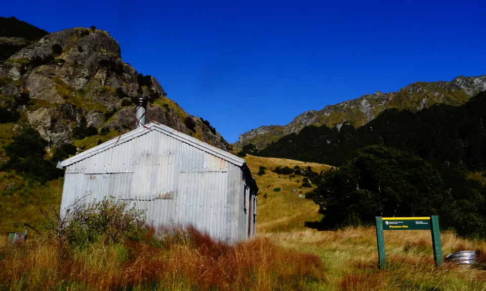
Before you go, make sure, you downloaded or purchased DOC brochure Skippers and recorded this track to your GPS (Smartphone).

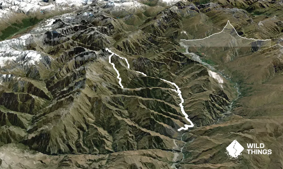
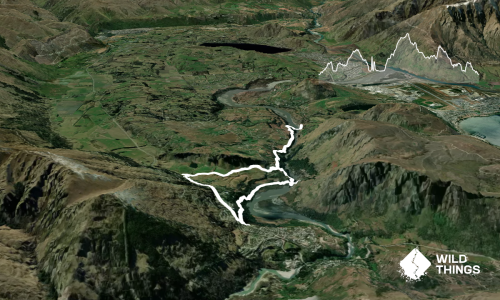
The 'run' (some parts are not runnable - approx. 40% of the trail) starts in Skippers Township. Follow the DOC sign (Dynamo Hut). After 1.5 km you will reach Skippers Creek. Cross it, do not try to avoid that. Follow this creek, that includes numerous river crossings (some parts are untracked but easy). Turn left to Dynamo hut Track. Follow the Skippers Creek Left Branch (heaps of river crossings) until you reach Dynamo Hut. Have a snack and continue.

After 1,5 km track turns left and goes to north following Aurum Creek. 6 km from Dynamo Hut is a steep way up (scree). Aim to the point 1872 a.s.l. (check topo map). You can take rest and consider if you are experienced enough to scramble Mt. Aurum. If you do not feel confident enough, do not do it!!! This one is pretty slippery, challenging and dangerous. Rock is pretty solid and you can use grass and tussocks too. Try to reach the ridgeline and from there it is a pretty easy way to top. Enjoy the great view and be careful on the way down.

From point 1872 continue down to Dandys Saddle and then continue down until you reach Skippers Creek Right Branch. After a few kilometers, you will reach Bullendale hut. From the hut, it is approx. 10km to carpark following the Skippers Creek (numerous river crossings again)

This trail includes the peak Mount Aurum .

Historic Skippers suspension bridge, Skippers Township, remains of Goldrush, remote area, Mt. Aurum, Cozy DOC huts

Carpark and DOC camp at the start

30 km

66 minutes

Unknown

No

Hard.

Use GPS (smartphone) - import GPX and follow it.

Non-existent.

Waterproof leggings, Thermal leggings, Lightweight fleece top, Short-sleeved thermal top, Long-sleeved thermal top, Seam-sealed waterproof jacket, Windproof jacket, Gloves, Beanie/thermal headwear, Personal Locator Beacon (PLB), Whistle, First aid kit, Extra food for emergencies, Survival blanket, Cellphone, Compass, Map, Headtorch and spare batteries, Crampons / microspikes (for winter conditions), Gaiters

The DOC huts have water tanks and creeks, these spring just under Mt Aurum.
Heavy metals continue to leach from the old mine workings here – DO NOT drink water from the creeks

Do not attempt in winter or after heavy rain. You will cross at least 50 times the river (first 9 km and the last 8 km)

Plenty of river crossing, running through tussock land, experience with route finding and some climbing experience are essential.

You and Mount Aurum - Skippers

As a VIP member you can record private notes for this trail, see all of your times and more.

Register Now

Already have an account? Login now

Trail Reviews

Be the first to submit a review for Mount Aurum - Skippers!

Login to submit a review

Trail Running Community

Find people who are interested in or have completed this trail run.

You must register or login to view this feature.

Register Now

Other trails nearby
Moke Lake from Mt.Crichton

Moke Lake from Mt.Crichton

Length: 27.5km

Level: Beginner - Intermediate

Moonlighting around Bowen Peak

Moonlighting around Bowen Peak

Length: 24.0km

Level: Beginner - Intermediate

Frankton to Morven Hill Return

Frankton to Morven Hill Return

Length: 30.0km

Level: Beginner - Intermediate

The Felic Relic

The Felic Relic

Length: 28.0km

Level: Beginner

Find more trails and peaks nearby