Last Updated: 9th Feb 2024

Intermediate - Experienced

Save Trail Save

I've done it Done

Routeburn-Caples

Glenorchy, Otago

Submitted by Mike Steel

Last Updated: 9th Feb 2024

Intermediate - Experienced

Save Trail Save

I've done it Done

Open

Grunt Factor: 79 ?

Gnarl Factor: 32 ?

54.0km

2000m

2100m

1250m


Login as a VIP to see driving directions, distance and time.

Trail Map

Type of Run

Back country - remote

Point to Point (one way)

Undulating, some big hills

Native bush

Riverside

Lakeside

Open tussock/grasslands

Open ridges/tops

Run Makeup

50%
50%

Easy Single Track

Moderate Single Track

Average Uphill Gradient: +9.2%

Average Downhill Gradient: -9.0%

Trailhead

Login as a VIP to see the trailhead information.

Estimated Times to Run

12:00

Slow

9:00

Moderate

6:00

Fast

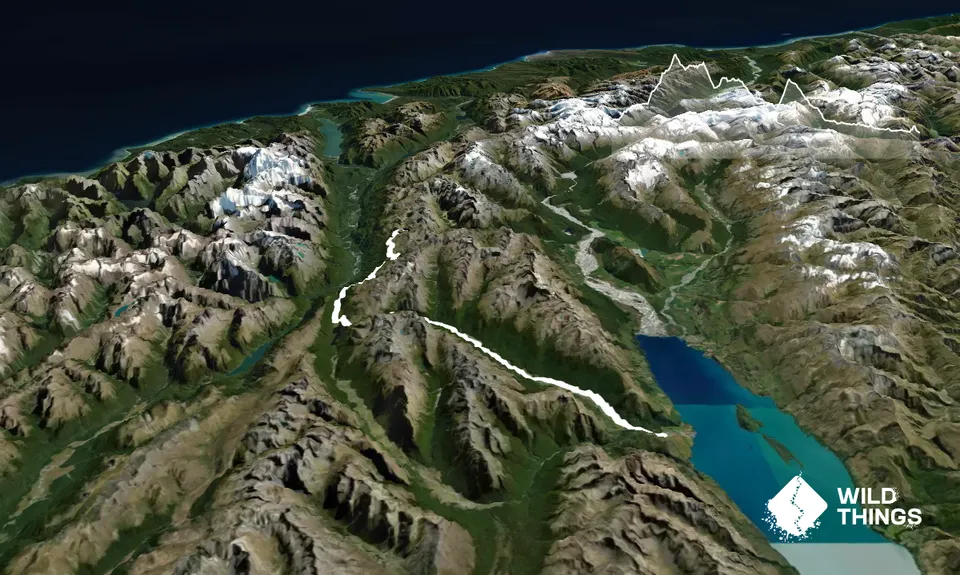
To Fiordland and back. An awesome journey with spectacular views of the high Fiordland mountains, bush, lakes, waterfalls, deep valleys, and more. It combines the Routeburn Great Walk with another classic tramping route. A 30k bike ride at the end gets you back to the car.

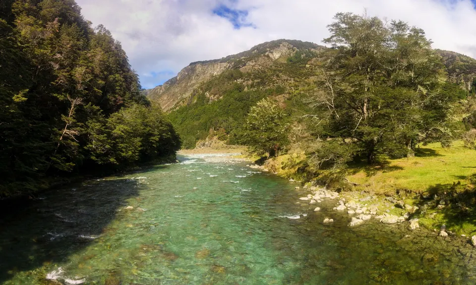
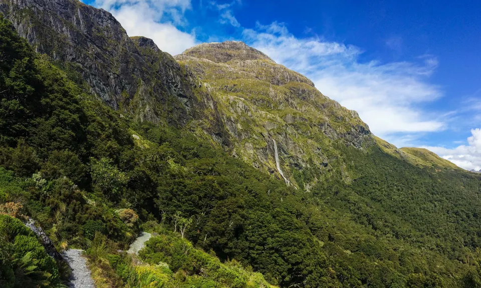
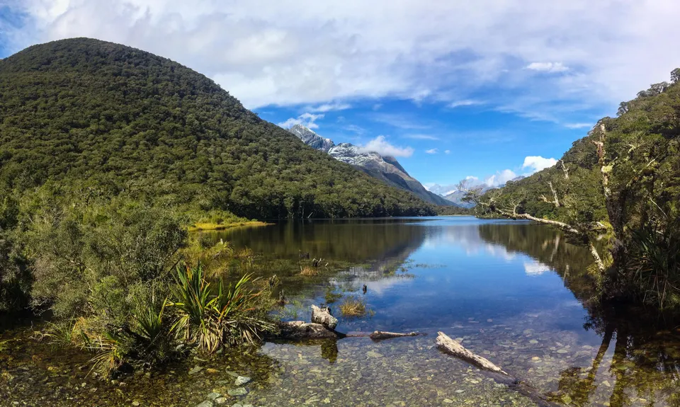
Place a mountain bike the night before at the Greenstone/Caples car park and camp at the DOC campsite that's a few km before the Routeburn track. Start early to avoid the many walkers on the `Great Walk' Routeburn track. A pleasant run takes you past Routeburn Falls Hut, and onwards climbing above the Lake Harris lake to Harris Saddle, with picture-postcard sweeping views, including the glaciated granite Darran mountains to the west. From here, an exhilarating run above the steep Hollyford Valley brings you down to the postcard Lake Mackenzie hut. Then it's a cruisy run to the Lake Howden Hut, where you avoid the last few km of the Routeburn and head off on the start of the Greenstone/Caples track. The Caples track is shorter, but involves a grunty climb up to McKellar saddle which has great views of the lower Hollyford peaks (Mt Christina). From here it is all downhill (though a bit slow until the Upper Caples hut) and an easy but lengthy run out down the open Caples valley past the mid-Caples Hut and out. [An alternative but longer return is via the Greenstone Valley]. The bike will be a welcome sight for the return journey beside the lake to the car.

Fiordland mountains, bush, lakes, waterfalls, deep valleys, and more.

25 km

28 minutes

Unknown

No

Moderate.

Following well-marked and signposted tracks the whole way, but take a topomap nevertheless.

Patchy.

Long-sleeved thermal top, Seam-sealed waterproof jacket, Beanie/thermal headwear, Whistle, First aid kit, Extra food for emergencies, Survival blanket, Cellphone, Map

Plenty of water along the way (and at huts).

Can be snowed under in winter.

Trail Legend

ZB

Zak Brown

has completed Routeburn-Caples once in the last year.

Learn about Trail Legends.

You and Routeburn-Caples

As a VIP member you can record private notes for this trail, see all of your times and more.

Register Now

Already have an account? Login now

Trail Reviews

I am speechless. That was phenomenal. Caples is stunning - overshadowed by its neighbour but it's well up there. Absolutely loved it.

Joe Benbow

March 27, 2023

Great run along the best Great Walk (Routeburn) and the very runnable Caples. Plenty of water on the Routeburn and out the Caples Valley, but fill up from the streams near Greenstone campsite as there's none going up and over McKellar saddle. Lots of places to swim in the Caples on the way out, especially the swimming hole just after Mid Caples hut.

Gareth Jenkins

January 25, 2023

A super stunning and runnable route. For sure recommend doing it Routeburn- Caples direction so that you have a long gradual descent after McKellar saddle. Remember to add extra time for numerous photo stops....all my 'quick photo stops' somehow added up to an extra 1h15 on top of running time!!

Katie Morgan.

December 29, 2021

Login to submit a review

Trail Running Community

Find people who are interested in or have completed this trail run.

You must register or login to view this feature.

Register Now

Overlapping Trails

These overlap with this trail to some degree. You may wish to combine them but please note that to qualify for FKTs on these runs you should record a separate activity for each.

Ailsa - Humboldt Circuit

Ailsa - Humboldt Circuit

Length: 64.0km

Level: Very Experienced

Conical Hill and Return

Conical Hill and Return

Length: 27.4km

Level: Beginner - Intermediate

Whisky Trail and Routeburn

Whisky Trail and Routeburn

Length: 58.0km

Level: Experienced

Other trails nearby
Sugarloaf Circuit

Sugarloaf Circuit

Length: 21.7km

Level: Intermediate - Experienced

Rees Dart Reverse Run

Rees Dart Reverse Run

Length: 63.0km

Level: Intermediate - Experienced

Lake Rere Loop

Lake Rere Loop

Length: 15.3km

Level: Beginner - Intermediate

McIntosh - Judah Loop

McIntosh - Judah Loop

Length: 19.0km

Level: Beginner - Intermediate

Find more trails and peaks nearby