Last Updated: 4th Apr 2025
The golden Waikakaho trail
Submitted by Jennifer Rankin
Last Updated: 4th Apr 2025
Grunt Factor: 42 ?
Gnarl Factor: 72 ?
13.3km
1205m
1215m
750m

Last Updated: 4th Apr 2025
Submitted by Jennifer Rankin
Last Updated: 4th Apr 2025
Grunt Factor: 42 ?
Gnarl Factor: 72 ?
13.3km
1205m
1215m
750m
Back country - remote
Out and Back
Very hilly
Native bush
Farm Road / 4WD Track
Technical Single Track
Average Uphill Gradient: +17.5%
Average Downhill Gradient: -17.6%
VIP Feature: Send this route to your Garmin account so you can follow the course on your Garmin device.
Login as a VIP to see the trailhead information.
2:05
Slow
1:50
Moderate
1:15
Fast
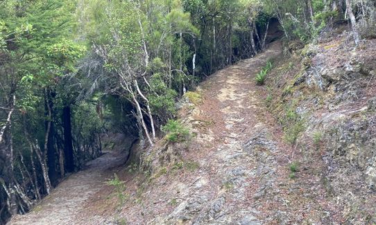
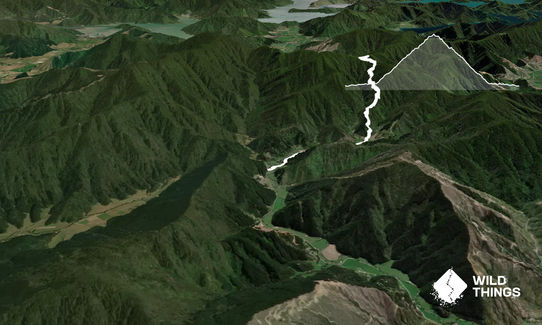
After leaving your car, proceed across the bridge and pass through the clearly marked first gate. Proceed through a second gate approximately 500m later and then follow the unsealed road for a further 2km.
You will come to two stream crossings. These are low flow in summer and easily crossable without getting your feet wet. Follow the marked trail up to a pedestrian gate. This is where the grunt begins.
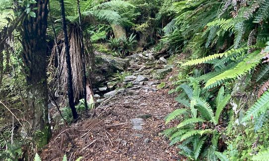
The path is clear and easy to follow. Starting off the gradient is quite demanding (hence the recommended run-in) but the condition underfoot is smooth and wide and shaded by manuka trees. After a kilometer or so the track becomes rockier and moves further into tree ferns and native beech forests.
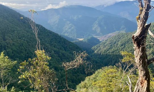
The track begins to have some more easily runnable switchbacks. The rocky outcrops, old mining scars, and native bush make this a truly magical run. All the way up you are rewarded with vistas out towards the Wairau Plains, Wither Hills, and Kaikoura ranges.
About a third of the way up you pass a sign indicating 'Tower site remains' towards the left, continuing on up the hill. After another kilometre or so you reach a sign indicating Loading Site and Village Clearing, take the right turn towards the Village Clearing.
At the Village Clearing proceed on to the track off to the left and continue up the hill, past the mine turn off, for just under a kilometre to the Cullensville/Waikakaho Sign.
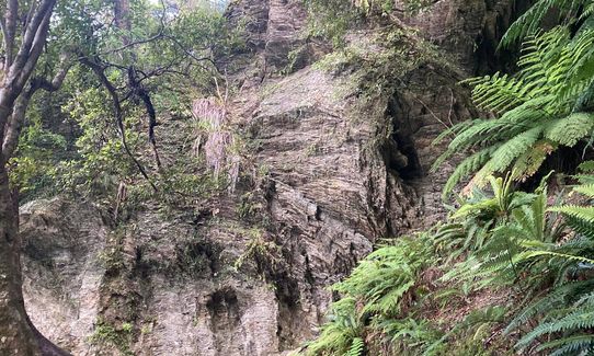
Now turn right and continue up through the bush to the Lookout (basically a rocky outcrop). The DOC track continues past the lookout but this is where you'll turn back the way you came to enjoy the fun of a marvellous, runnable, technical but reasonably easy descent. The top half of the descent is reasonably rocky and some care needs to be taken on the looser stones.
This is an old gold miners trail and there are some old mining areas and features of interest on the route. There are some wonderful rock outcrops, small streams and bountiful birdlife.
If you know of any public toilets near the trail start or on the route, please login and then let us know so we can update this section.
This route starts prior to the bridge where the gated road begins. Parking can be done on the road verge, further parking (if driving a 4x4) is available by driving 2km further along the 4x4 track (Please respect gates!)
26 km
32 minutes
No
No
Moderate.
When you reach a sign that indicates Loading Site or Village Clearing turn right and follow the path uphill to the village, the path continues to the left of the village clearing.
Very patchy.
Personal Locator Beacon (PLB), Whistle, First aid kit, Extra food for emergencies, Cellphone, Map
There are a number of small streams and there is a river crossing at the start but the quality of the water cannot be verified. Would recommend carrying a minimum of 2l on a hot day.
This route has a couple of stream crossings, in summer these do not have any impact. During winter things will be a lot slipperier and some extra care may be required.
There is one large rock between the Village and the saddle which is slippery with moss and only has a couple of good footholds. It is located next to a steep dropoff. Extra care should be taken here.
Raupo's
Blenheim
https://www.raupocafe.co.nz/
Great selection of food and a good outdoor dining area overlooking the river.
Trail Legend
Login as a VIP to become a Trail Legend. Learn about Trail Legends.
Fastest Known Times (FKTs)
You and The golden Waikakaho trail
As a VIP member you can record private notes for this trail, see all of your times and more.
Already have an account? Login now
A great trail, just the right amount of steep! I completed in September and a few words of caution as the trail doesnt get much sun it stays pretty damp and mossy, the moss and the clay soil made for some ice skating on the way down even in trails shoes. There were a few trees down too though nothing you cant clamber over and I definitely had to get wet feet over the little stream crossing. I would go back but will wait until summer!
September 6, 2024
Send to your phone
Scan the below QR code to open this trail on your phone.

Tip: position the QR code in your phone camera screen.


