Last Updated: 24th Mar 2024

Beginner - Intermediate

Save Trail Save

I've done it Done

Takorika Bites!

Blenheim, Marlborough

Submitted by Mike Tennent

Last Updated: 24th Mar 2024

Beginner - Intermediate

Save Trail Save

I've done it Done

Open

Grunt Factor: 20 ?

Gnarl Factor: 60 ?

8.5km

885m

870m

721m


Login as a VIP to see driving directions, distance and time.

Trail Map

Type of Run

Urban

Loop

Mountainous

Native bush

Plantation/exotic forest

Open tussock/grasslands

Open ridges/tops

Run Makeup

8%
20%
14%
8%
50%

Sealed Road

Farm Road / 4WD Track

Easy Single Track

Moderate Single Track

Technical Single Track

Average Uphill Gradient: +20.3%

Average Downhill Gradient: -20.0%

Trailhead

Login as a VIP to see the trailhead information.

Estimated Times to Run

3:30

Slow

2:30

Moderate

1:30

Fast

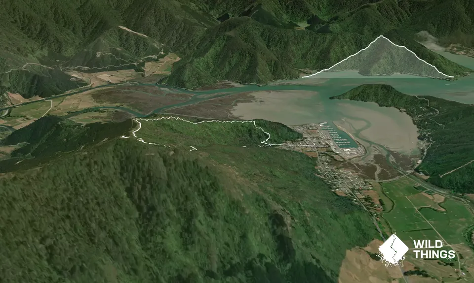
Head up the trail and, at the very start, there is a box on the side with walking sticks (straight branches), for use when climbing. Head on up the 4wd road through the gate ignoring the side trails.

About 400m from where you left the sealed road you will see a sign for Takorika Peak, start your climb in earnest. From here it is a straightforward slog following the signs for Takorika. However you do have choices: firstly is the Lookout Loop off to your left, this does what it says and loops out to a viewpoint and then climbs back to the trail further up. Then further up you will come to an intersection with the option of going left again onto the Escarpment Track. Again this lengthens the route but the climbing is probably a bit easier.

Eventually, just short of the top, you will come out onto the 4WD track. From the top, head back down the 4WD track/road for 1.2km passing the Waterfall Track and the MTB Track signs until you are right at the transmitter tower, follow the grassy signposted track (Ridge Track) to the right of the tower and start heading down.

Parts of this are runnable and parts not, so take care. Follow all the way down to an intersection nearly at the bottom with three options, take the one that heads down (the centre one) and it will spit you out just above the box to put your walking sticks in. Then back to your car and into town for a beer!

This trail includes the peak Mount Takorika.

Views, views and more views... stunning views over the Havelock area of the Sounds.

Plenty of parking on the road.

0 km

0 minutes

Unknown

No

Moderate.

Ignore all signs for Waterfall Track and stick to the Takorika Peak signs and orange triangle route.

Generally good.

Waterproof leggings, Long-sleeved thermal top, Seam-sealed waterproof jacket, Windproof jacket, Gloves, Beanie/thermal headwear, Personal Locator Beacon (PLB), Whistle, First aid kit, Extra food for emergencies, Survival bag, Cellphone, Map

A few small streamlets early, but nothing after that, so take plenty.

Much of this trail is very steep going on dirt trail that would be treacherous either uphill or downhill after lots of rain or in the wettest parts of winter. Discretion is advised before attempting it in those conditions.

Lots of narrow, sloping, trail with loose scree on the 4WD tracks and of course tree roots and rocks.

Trail Legend

Trish Thorne

Trish Thorne

has completed Takorika Bites! once in the last year.

Learn about Trail Legends.

You and Takorika Bites!

As a VIP member you can record private notes for this trail, see all of your times and more.

Register Now

Already have an account? Login now

Trail Reviews

Be the first to submit a review for Takorika Bites!!

Login to submit a review

Trail Running Community

Find people who are interested in or have completed this trail run.

You must register or login to view this feature.

Register Now

Other trails nearby
Torea Bay to Picton Loop

Torea Bay to Picton Loop

Length: 45.1km

Level: Intermediate - Experienced

Patriarch Road and Goulter Valley

Patriarch Road and Goulter Valley

Length: 25.0km

Level: Intermediate - Experienced

A Full Chalice

A Full Chalice

Length: 11.6km

Level: Beginner - Intermediate

Dam Dam

Dam Dam

Length: 10.0km

Level: Beginner

Find more trails and peaks nearby