Wild Things - New Zealand's trail running community
New Zealand's trail running community

Login


don't have an account?

Te Ara O Wairakei, Bay of Plenty

Trail Directory proudly supported by Further Faster

Update Your Header Picture

Te Ara O WairakeiBeginner

Info Info
Map Loading

Trail Information

21.40km

16m

16m


Bay of Plenty

Tauranga

Urban

Loop

Totally/mostly flat

Other

Beginner

2:30 (Slow)
2:00 (Moderate)
1:30 (Fast)

-1%

+1%

Download PDF Guide

Fastest Known Times (FKTs)

Please set your gender to see your position on the FKT leaderboards.

Men

There are currently no male FKTs for Te Ara O Wairakei.

Women

There are currently no female FKTs for Te Ara O Wairakei.

Filter FKTs

The more , the harder the FKT will be to beat. Learn about Fastest Known Times.

Missing your time?

Register or login as a VIP and get yourself on the FKT leaderboard!

Register Now

Description

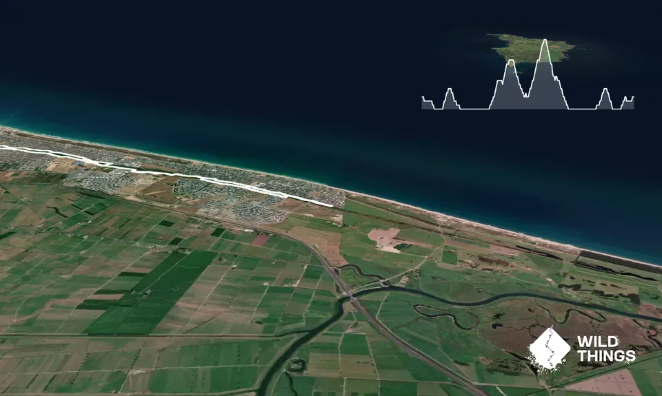
This trail is not super wild, but is a decent training run avoiding the otherwise road-heavy routes around uban Papamoa!

If you assume a start point at the end east of Emerald Shores, and run northside heading west, southside on the way back east: run heading west, cross Emerald Shores Dr, keep going, crossing Golden Sands and Palm Springs Blvd.

Just up from here, the gravel track stops. There is a plank of wood over the stream 20 metres before the track end, and then a worn trail through the farmland to get back onto the gravel trail past Maungaronga Walkway. The other option here is to head up Mandalay Key, onto Santa Cruz Drive and then down Simpson Road to Parton Road.

Once you reach Parton Road, run along the north side of the waterway, crossing Longview, Opal, and Domain. Once past the back of the shops, the trail bends right then splits; take the right fork, cross Gravatt Rd and turn left, then right back onto the trail just after the roundabout.

Stay on the northside trail, cross Palm Beach Blvd, Hartford, and Evans. After Evans, stay northside of the water, run on the grass (clear use as a trail) through to Pacific View Rd, where pathway ends.

Cross over to southside and head back, crossing Evans and Hartford. As at Feb 2022, northside is temp closed for pipework east of Hartford, so use southside until first bridge on your right - take that bridge back across to northside and turn left to continue heading east.

In a couple of hundred metres the trail bends right and heads south for a few hundred metres before bending left/east and through the section of rollers before crossing Palm Beach. Past the playground, the trail bends north for a bit then east again, popping out onto Riviera Court cul de sac. Straight ahead to Montego Dr, turn left then in 50m left onto paved path for 20m then right onto gravel path - you're back on Te Ara Wairakei southside!

Carry on to Gravatt and cross, turn left and cross Beachwater straight onto path again, bending left to head back past back of shops to Domain.

East of Domain, continue southside, crossing Longview and Parton. East of Parton, you're heading back down where you came up, through the farmland (or Simpson) and back onto Te Ara o Wairakei (you'll be on north side). Cross Palm Springs Blvd and head right then turn left to get onto southside path. Carry on until you run out of southside path, carry on east, crossing Golden Sands Rd, through to the pond at the end of the southside trail - run the loop around the pond then cross the bridge to northside for the last little bit back to trail end.


Trail Community

Find people who are interested in this run.

You must register or login to view this content.

Features of interest

The route follows the Wairākei Stream, whcih is now more of a stormwater reserve, but nice none the less.


Make Up of Run

Easy Single Track: 5%

Farm Road / 4WD Track: 95%


Route Data

Reviews:

You must register or login to view this content.

Photos:

You must register or login to view this content.

Your Trail Wishlist

All the runs that are on your To Do list (no limit).

Add to wishlist view wishlist

Your Trail Dreamlist

The runs you most want to do (limited to 10).

Add to dreamlist view dreamlist

Wild Explorers

I did it!
  • Access

    This trail is very sectionable and start/finish can be wherever you want on-route.

    Plenty of on street parking whereever you choose to start.

    22 km

    27 minutes

    Yes

    No

  • Staying Safe

    Easy.

    Running east to west, the gravel track stops just after Palm Springs Blvd. There is a plank of wood over the stream 20 metres before the track end, and then a worn trail through the farmland to get back onto the gravel trail past Maungaronga Walkway. The other option here is to head up Mandalay Key, onto Santa Cruz Drive and then down Simpson Road to Parton Road.

    Perfect throughout.

    Cellphone, Map.

    There are no water foundations en-route, and the stormwater/stream water is definitely not drinkable, but you do pass close to a few shops and dairies if you need a top up.

  • Sponsor this trail

    If you are interested in learning about sponsorship opportunities, please get in touch below:

    Submit

Got a favourite trail? Tell us about it.

Share the love and add your favourite trail(s) to our growing trail directory.

Submit A Trail

Become a member today

Start enjoying the many benefits to becoming a member of our thriving community.

Become a member

Great brands at great prices with our VIP member's discount

Stay up to date

Sign up to our newsletter for latest offers and trail guides

Share this trail with a friend:

VIP Membership

Please register as a VIP or login to your VIP account to view this content.

Cancel Login Register

Membership Required

You can see up to three trail guides without being logged in but after that we require you to be logged in to your Free or VIP account. If you don’t yet have an account you can register here.

Login Register