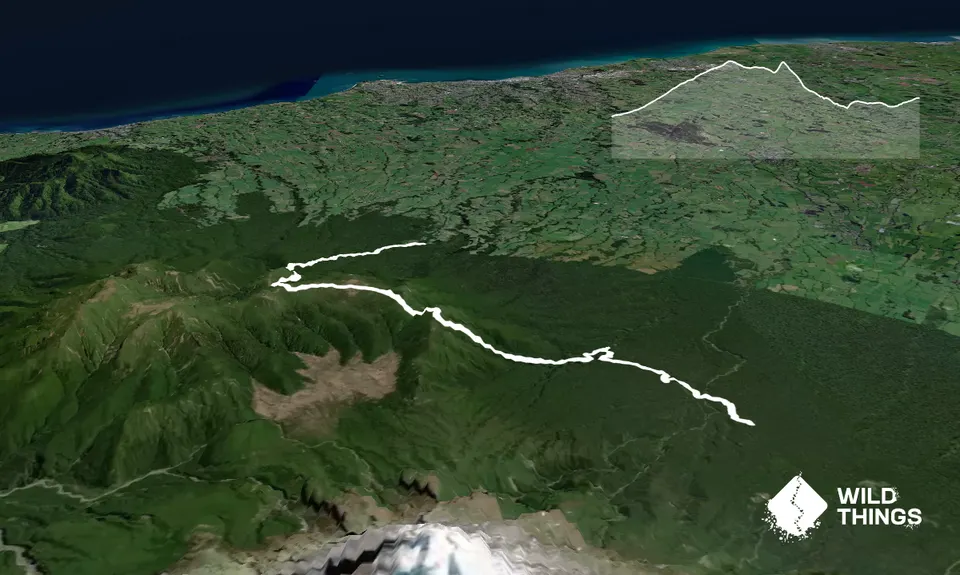
Mangorei to North EgmontIntermediate
Submitted by Aaron Wilks
Front country - easily accessible
Point to Point (one way)
Mountainous
Native bushOpen tussock/grasslandsOpen ridges/tops
Intermediate
3:30 (Slow)
2:30 (Moderate)
1:45 (Fast)
-15.0%
+13.7%
Fastest Known Times (FKTs)
Please set your gender to see your position on the FKT leaderboards.
Men
Women
Filter FKTs
The more , the harder the FKT will be to beat. Learn about Fastest Known Times.
Description
Track is a one way run so requires a drop off and pickup or a car drop. Head up Mangorei Road to the top and park on the side of the road. Start up the gravel driveway at the road end it will then turn into the board walk up to Pouakai Hut. Follow the track all the way past Pouaki Hut to the ridge. There is a junction right to Holly Hut and the Ahukawakawa swamp, you head left towards Pouakai Tarns/Henrys Peak along Pouakai Track. Follow the board walk past The Tarns (a photo must) on towards Henrys Peak and the lookout for the Ahukawakawa swamp on the summit. When back underway the boardwalk continues for another 1km then turns into single track which is quite rugged and gnarly in places, up and down a few ridges past Kaiauai shelter. At the next track intersection turn left towards Kaiauai Car Park over the swing bridge and follow the signs to the road/carpark, mission done.
Trail Community
Features of interest
Great mountain views, outlook over the Ahukawakawa Swamp, Pouakai tarn, swing bridge.
Make Up of Run
Untracked / Route only: 30%
Moderate Single Track: 40%
Easy Single Track: 29%
Gravel Road: 1%
Route Data
Reviews:
Overlapping Runs
The following trails overlap with this run to some degree. You may wish to combine them but please note that to qualify for FKTs on these runs you should record a separate Strava activity for each

Pouakai Hut and Tarns
Length: 12.30km

Pouakai Summit
Length: 16.70km

Pouakai Circuit
Length: 24.00km
Photos:
Your Trail Wishlist
All the runs that are on your To Do list (no limit).
Add to wishlist view wishlistWild Explorers
I did it!-
Access
Track starts at the top of Mangorei Road end.
Parking on the side of the road, can get busy during summer, plans are under way to make a bigger car park.
19 km
22 minutes
No
No
-
Staying Safe
Moderate.
Patchy.
Waterproof leggings, Thermal leggings, Long-sleeved thermal top, Seam-sealed waterproof jacket, Gloves, Beanie/thermal headwear, Whistle, First aid kit, Extra food for emergencies, Survival bag, Cellphone, Map.
Plan on taking all your own water, but there are 3 or 4 creeks and a river 1hr from the end if needed.
Being a mountainous environment conditions can change to extremes within the hour especially winter, last part of the track is muddy after rain and in autumn & winter, ridges are exposed to wind.
-
Sponsor this trail
See other runs nearby:
Tahurangi Traverse
Pouakai Hut and Tarns
Ninja Stealth Urban Trail
Pouakai Summit
Waiwhakaiho Track
Makatawa Loop
Lake Mangamahoe
Holly Hutt Track
Up The Stony
Kokowai Loop
Kahui Hut
Pouakai Crossing
Meeting of the Waters
Davies Track
NP Urban Trail Run
Pouakai Circuit
Rain Forest Romp at Pukeiti
White Cliffs
Taranaki RTM with a Twist
Looping Lucys
Ratapihipihi
Mangakotukutuku Falls
Fanthanaki double summit loop
Mana Bay- Patea river and beach