Last Updated: 22nd Apr 2024

Beginner - Intermediate

Save Trail Save

I've done it Done

Iris Burn Marathon

Te Anau, Southland

Submitted by Sierra

Last Updated: 22nd Apr 2024

Beginner - Intermediate

Save Trail Save

I've done it Done

Open

Grunt Factor: 48 ?

Gnarl Factor: 26 ?

44.0km

880m

880m

492m


Login as a VIP to see driving directions, distance and time.

Trail Map

Type of Run

Front country - easily accessible

Out and Back

Undulating, some big hills

Native bush

Open tussock/grasslands

Run Makeup

50%
50%

Easy Single Track

Moderate Single Track

Average Uphill Gradient: +3.9%

Average Downhill Gradient: -3.9%

Trailhead

Login as a VIP to see the trailhead information.

Estimated Times to Run

6:30

Slow

5:15

Moderate

4

Fast

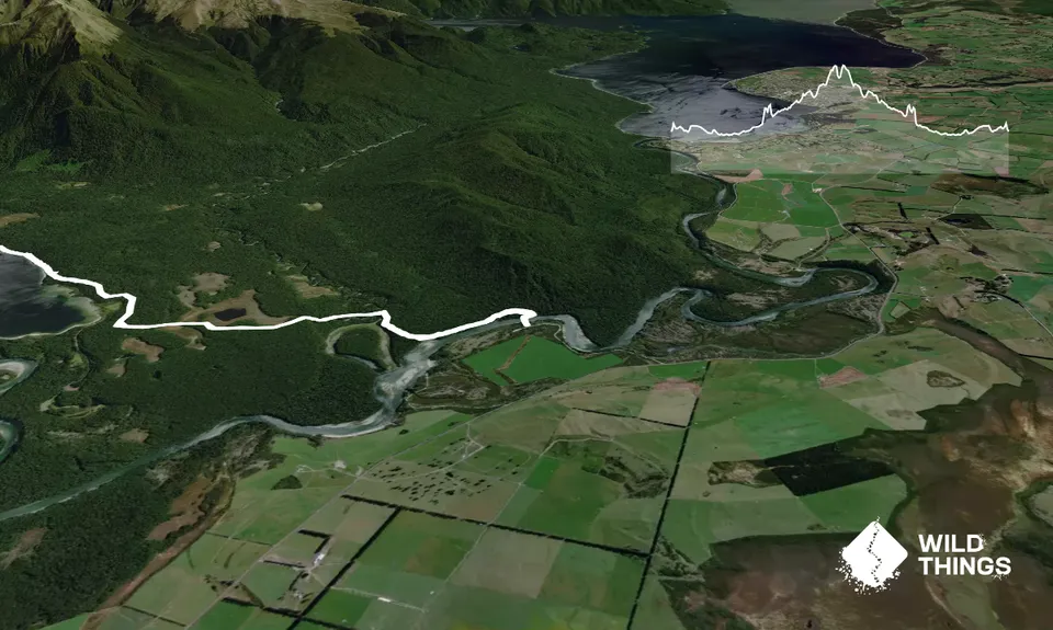
A great way to run a marathon distance on easily accessible trail near Te Anau and Manapouri!

This section of the Kepler between Rainbow Reach and Iris Burn Hut is lovely undulating forest trail, making a gradual ascent. You're also protected from the elements in the forest here, and being at lower altitude, this section is possible year-round weather permitting. From Rainbow Reach carpark, cross the bridge over the Waiau River, then at the fork follow signs for Moturau Hut.

About 6 km in, you will arrive at Moturau, where you can use the facilities and enjoy the beach on Lake Manapouri. There are sandflies here though! The trail continues undulating through the forest until you meet your next landmark about 8 km after Moturau Hut, the Rocky Point Shelter, where you can use the toilet. This shelter represents the halfway mark between Moturau and Iris Burn Huts.

You may spot whio (native blue ducks) anywhere in the Iris Burn between here and Iris Burn Hut!

After Rocky Point Shelter is when you feel that the trail really starts to climb a bit. It flattens again as you cross "The Big Slip," formed by a flood in the 1980s-- takahē have occasionally been spotted here, having wandered over from the Murchison mountains. After crossing the Big Slip, the track climbs a bit again, and you are nearly there! Iris Burn hut, the turn-around point, is a great place to have a rest, use the toilets, and re-fill waters before heading back the same way you came. There are, however, sandflies about. Kea and kiwi are also known to live in the vicinity.

The run back should be slightly easier as you will gradually be losing altitude.

Plenty of parking available, there are also shuttles from Te Anau with Tracknet or Topline.

0 km

0 minutes

No

No

Easy.

Follow the DOC Kepler signs for "Moturau Hut" and "Iris Burn Hut" on your way out, then to "Moturau Hut" and "Rainbow Reach" on your way back.

Very patchy.

Windproof jacket, Gloves, Personal Locator Beacon (PLB), Whistle, First aid kit, Extra food for emergencies, Cellphone, Map

Water is available at both huts, as well as from rivers/streams running between Moturau and Iris Burn. The water there is generally fine to drink.

Being in the forest and low altitude, this track is somewhat protected from elements, making it possible to do most the year provided the weather is (and has been) decent.

Trail Legend

Crystal Brindle

Crystal Brindle

has completed Iris Burn Marathon 4 times in the last year.

Learn about Trail Legends.

You and Iris Burn Marathon

As a VIP member you can record private notes for this trail, see all of your times and more.

Register Now

Already have an account? Login now

Trail Reviews

Be the first to submit a review for Iris Burn Marathon!

Login to submit a review

Trail Running Community

Find people who are interested in or have completed this trail run.

You must register or login to view this feature.

Register Now

Overlapping Trails

These overlap with this trail to some degree. You may wish to combine them but please note that to qualify for FKTs on these runs you should record a separate activity for each.

Kepler Track

Kepler Track

Length: 60.1km

Level: Intermediate

Other trails nearby
Waiau River Loop

Waiau River Loop

Length: 23.6km

Level: Beginner - Intermediate

Gobsmacking Gertrude

Gobsmacking Gertrude

Length: 8.9km

Level: Very Experienced

Caples Track - The Divide Version

Caples Track - The Divide Version

Length: 31.0km

Level: Intermediate

Whisky Trail and Routeburn

Whisky Trail and Routeburn

Length: 58.0km

Level: Experienced

Find more trails and peaks nearby