Last Updated: 17th Feb 2024

Beginner

Save Trail Save

I've done it Done

Coasting

Dunedin, Otago

Submitted by Gwilym Rivett

Last Updated: 17th Feb 2024

Beginner

Save Trail Save

I've done it Done

Open

Grunt Factor: 24 ?

Gnarl Factor: 36 ?

22.0km

460m

460m

321m


Login as a VIP to see driving directions, distance and time.

Trail Map

Type of Run

Urban fringe

Combo

Undulating, some big hills

Dog Friendly

Beach

Coastal

Open farmlands

Run Makeup

30%
20%
10%
10%
30%

Sealed Road

Gravel Road

Easy Single Track

Moderate Single Track

Untracked / Route only

Average Uphill Gradient: +3.1%

Average Downhill Gradient: -5.9%

Trailhead

Login as a VIP to see the trailhead information.

Estimated Times to Run

3:30

Slow

2:00

Moderate

1:30

Fast

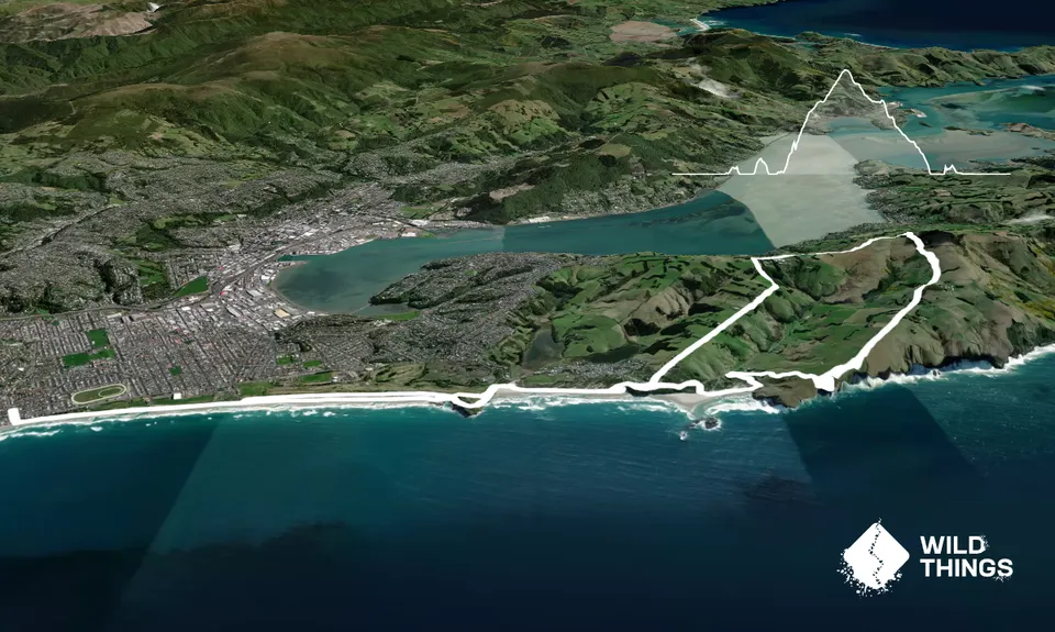
Set out along the beach from the Esplanade in St Clair heading North. Run the length of the beach and then up the dunes at the end crossing the sealed road to join the golf course (watch out for strangely dressed folk with sticks).

Make your way around the golf course on the cliff edge until there is an obvious path down a bluff on your right that takes you down to Tomahawk Beach. Cross the stream at the bottom and run the full length of the beach, again exiting up the dunes to the tar sealed road above.

Run up the tar sealed road for a couple of hundred metres and take the first right down towards Smaills Beach. Head down hill and take the first track on the right down through the dunes to the beach (watch out for sea lions). Run the length of this beach.

Follow a stream at the far end inland - a track emerges that brings you out onto a gravel road. Take the right hand fork past Dunedin and Haast fishing - this leads you to the signed Karetai Track, continue up hill. This track becomes a gravel road then a sealed road and takes you all the way to Highcliffe Road where you turn left towards the city with views towards Mt Cargill on your right.

Head along Highcliffe road for a couple of kilometres and take the left signed to Ocean Grove. Run down the hill to the beach where you retrace your steps to St Clair. Grab a coffee and cake from one of the cafes.

Seabirds and occasionally sea lions.

Bus route 8 from city centre. Parking plentiful - watch out for bogans.

4 km

8 minutes

Yes

No

Easy.

Generally good.

Short-sleeved thermal top, Windproof jacket, Whistle, First aid kit, Extra food for emergencies, Cellphone, Map

St Clair - not really anywhere on route.

None.

Don't fall off any cliffs.

Starfish Cafe
Esplanade, St Clair
https://starfishcafe.co.nz
Great food and coffee.

The Esplanade
The Esplanade, St Clair
https://www.esplanade.co/
Wood fired pizza.

Trail Legend

FR

Finn Ryder

has completed Coasting once in the last year.

Learn about Trail Legends.

You and Coasting

As a VIP member you can record private notes for this trail, see all of your times and more.

Register Now

Already have an account? Login now

Trail Reviews

Be the first to submit a review for Coasting!

Login to submit a review

Trail Running Community

Find people who are interested in or have completed this trail run.

You must register or login to view this feature.

Register Now

Overlapping Trails

These overlap with this trail to some degree. You may wish to combine them but please note that to qualify for FKTs on these runs you should record a separate activity for each.

Karetai Soldier

Karetai Soldier

Length: 11.2km

Level: Beginner

Other trails nearby
Ross, Pineapple, Frasers loop

Ross, Pineapple, Frasers loop

Length: 18.5km

Level: Beginner - Intermediate

Seal Point Rd to Sandymount

Seal Point Rd to Sandymount

Length: 7.4km

Level: Beginner

2.8 Peaks Dunedin

2.8 Peaks Dunedin

Length: 28.0km

Level: Intermediate

Pineapple and Flagstaff

Pineapple and Flagstaff

Length: 7.6km

Level: Beginner - Intermediate

Find more trails and peaks nearby