Last Updated: 27th Nov 2023

Intermediate

Save Trail Save

I've done it Done

3 Peaks Plus 1

Dunedin, Otago

Submitted by Steve Tripp

Last Updated: 27th Nov 2023

Intermediate

Save Trail Save

I've done it Done

Grunt Factor: 78 ?

Gnarl Factor: 30 ?

55.0km

2880m

2865m

730m


Login as a VIP to see driving directions, distance and time.

Trail Map

Type of Run

Urban fringe

Point to Point (one way)

Very hilly

Native bush

Plantation/exotic forest

Open ridges/tops

Run Makeup

5%
5%
10%
50%
20%
10%

Sealed Road

Gravel Road

Farm Road / 4WD Track

Easy Single Track

Moderate Single Track

Technical Single Track

Average Uphill Gradient: +10.6%

Average Downhill Gradient: -10.5%

Trailhead

Login as a VIP to see the trailhead information.

Estimated Times to Run

11:00

Slow

8:00

Moderate

6:00

Fast

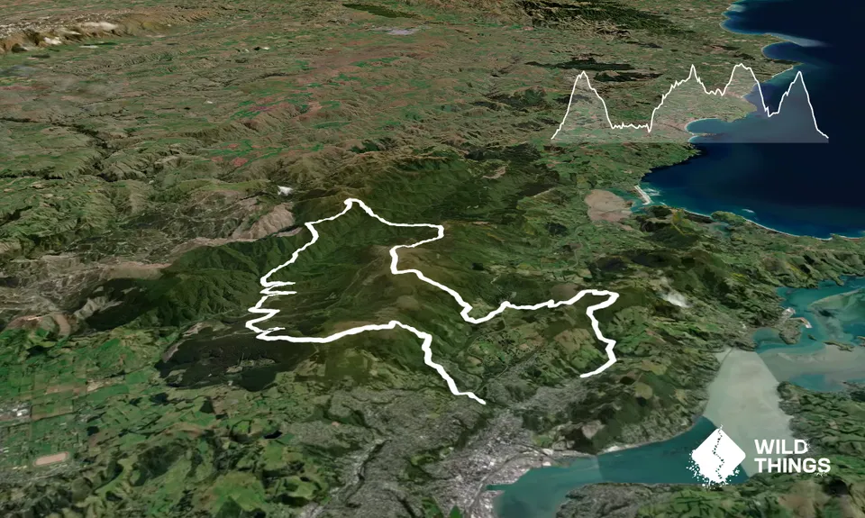
The run starts on Woodhaugh St and in 400 turns into the Ross Creek reservoir reserve. Follow those trails up to join the Pineapple track for the first big climb up Flagstaff.

Carry on over to the bullring on Whare Flat Rd and cross the road to join the Longridge Rd forestry road. 1.5km down that turn right onto Smeatons track and join back onto Longridge Rd at the bottom. Back onto Whare Flat Rd then onto Tunnel Track. Keep following that and along beside the water race until the route down to Powder Creek.

Cross Silverstream (probably with wet feet) and 500m later turn right for the big climb up Powder Ridge and then up Long Ridge to Pulpit Rock the course highpoint. Follow Green Ridge down to Hightop and then turn right toward Swampy Summit.

At Swampy pass the Summit and head for the cell tower then down Leith Saddle track turn right into the flax track to head down into Morrisons Gully and Leith Valley.

Head up Leith Valley Rd for 1.5km and just over the bridge turn left in the track through the forestry to head up Mt Cargill.

From the summit head down the trail to Bethunes and follow the road to the finish at Mt Cargill.

This trail includes the peaks Flagstaff, Swampy Summit, Mount Cargill, Hightop and Pulpit Rock.

Obviously the biggest feature of interest is this is the route for the 3 Peaks Mountain Race 55km distance. Also you pass a historic water race that used to provide Dunedin's water supply in the 1880s. Lots of really nice native bush sections with good bird life thanks to an active pest management programme.

Usually a bit of on-street parking is available on Woodhaugh St or Malvern St.

0 km

0 minutes

Unknown

No

Moderate.

There's a lot of other trails around so best to download a gpx onto your phone or watch and follow that. Or you can enter the race and it will be well marked and marshalled.
Cell coverage is available on the tops but patchy elsewhere.

Patchy.

Thermal leggings, Long-sleeved thermal top, Seam-sealed waterproof jacket, Gloves, Beanie/thermal headwear, Whistle, First aid kit, Extra food for emergencies, Survival bag, Cellphone, Map

Water in Silverstream (20km) is drinkable. Apart from that there is almost nothing.

Swampy ridge is always muddy. Rain at any time of the year can add a bit more in other sections. Silverstream (20km) can be high in a massive deluge but usually OK the day after. Pulpit Rock and Swampy sections are high and exposed and can get very cold and windy with no visibility in bad weather than can be any time of the year.

Rocks, mud, river crossing that might be high in very high rainfall.

Inch Bar
8 Bank St
https://www.facebook.com/Inch-Bar-100507150007389/
Good beer Good company Great atmosphere Open fire in winter

Trail Legend

Nathan Seed

Nathan Seed

has completed 3 Peaks Plus 1 once in the last year.

Learn about Trail Legends.

You and 3 Peaks Plus 1

As a VIP member you can record private notes for this trail, see all of your times and more.

Register Now

Already have an account? Login now

Trail Reviews

Be the first to submit a review for 3 Peaks Plus 1!

Login to submit a review

Trail Running Community

Find people who are interested in or have completed this trail run.

You must register or login to view this feature.

Register Now

Overlapping Trails

These overlap with this trail to some degree. You may wish to combine them but please note that to qualify for FKTs on these runs you should record a separate activity for each.

Mt Cargill and Organ Pipes

Mt Cargill and Organ Pipes

Length: 10.5km

Level: Beginner - Intermediate

Whare Flat to Pulpit Rock

Whare Flat to Pulpit Rock

Length: 20.4km

Level: Intermediate

The Bullring Basher

The Bullring Basher

Length: 37.0km

Level: Intermediate

The 3 Peaks

The 3 Peaks

Length: 26.4km

Level: Beginner - Intermediate

Other trails nearby
Orokonui Heaven

Orokonui Heaven

Length: 10.0km

Level: Beginner

Graham's Grunt

Graham's Grunt

Length: 10.0km

Level: Beginner - Intermediate

Racing to Rain Gauge

Racing to Rain Gauge

Length: 16.0km

Level: Beginner - Intermediate

Taieri Mouth Millenium Trail

Taieri Mouth Millenium Trail

Length: 14.6km

Level: Intermediate

Find more trails and peaks nearby