Whirinaki Long LoopIntermediate
Submitted by Ben Alton
Front country - easily accessible
Loop
Undulating, some big hills
Native bushRiverside
Intermediate
Not Suitable (Slow)
18:00 (Moderate)
14:00 (Fast)
-6.1%
+7.5%
This is a challenging run, although the start and the end of the track are well maintained and easy running, most of the back half is either only marked, diverted or affected by tree fall and slips. The trail constantly crosses streams and the Whirinaki River so be prepared to have wet feet all day/both days.
Fastest Known Times (FKTs)
Please set your gender to see your position on the FKT leaderboards.
Men
Women
There are currently no female FKTs for Whirinaki Long Loop.
Filter FKTs
The more , the harder the FKT will be to beat. Learn about Fastest Known Times.
Description
This is a great adventure run to do with a couple of friends. Pack up that sleeping bag and pick a hut to stay the night, or go full beast mode and do it in a day.
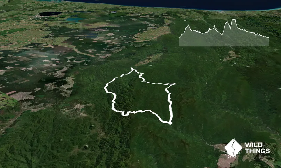
At the trailhead, you run a short distance (less than 5k) before you make your first turn, head left to begin the loop in a clockwise direction. From here it’s simple, just follow the signs and the orange markers. At Rogers hut, you have another left turn to make, so that you head to Mangakahika Hut and then another left after Upper Whirinaki Hut. It would pay to print the maps or at least the DoC brochure. On the back part of the loop, from upper Te Hoe Hut, the track had a lot of tree fall and slips, this meant we had to cross the water many times and on occasion head straight down the stream until the track became clear again.
We tackled this loop over 2 days, staying at Upper Te Hoe Hut overnight (49km day one, 38km day two). There are 8 huts along the circuit, all have water and toilet facilities so you can avoid carrying too much water. You will see from the GPX file that we visited every hut on the loop, some huts are on or just off the track, the longest detour is 500m each way. We all took a sleeping bag, cooking gear, down jacket for the evening (we did the loop in August) and a survival blanket. We also had a Personal Locator Beacon, just in case.
Trail Community
Features of interest
DoC huts are spaced along the route, giving you access to drinking water, toilets and shelter.
Make Up of Run
Untracked / Route only: 25%
Technical Single Track: 25%
Moderate Single Track: 25%
Easy Single Track: 25%
Route Data
Reviews:
Photos:
Your Trail Wishlist
All the runs that are on your To Do list (no limit).
Add to wishlist view wishlistWild Explorers
I did it!-
Access
The loop starts from the carpark at the trail head, look for signs
Driving from Rotorua, it's about a 80 minute drive. Head south and turn for Murupara before Rainbow Mountain, at SH 38, contunue along 38 until Minginui Road on your right. Next you are looking for a crossroads, you need to go right here. If you get to a narrow bridge, you have gone too far.
91 km
83 minutes
No
No
-
Staying Safe
Moderate.
It is important to follow the orange track markers. Print the map or the brochure so you know which hut to head to. ViewRanger has the updated route from Upper Te Hoe hut, we have seen some older ordinance survey maps wich include the old track, which has been closed for some time.
Non-existent.
Waterproof leggings, Thermal leggings, Lightweight fleece top, Long-sleeved thermal top, Seam-sealed waterproof jacket, Gloves, Beanie/thermal headwear, Personal Locator Beacon (PLB), Whistle, First aid kit, Extra food for emergencies, Survival bag, Cellphone, Compass, Map, Headtorch and spare batteries, Gaiters.
Water is available at all 9 huts and the river water is clean. We carried 500ml bottle and refilled at every opportunity, in the summer or if you are a heavy sweater you might need 1 litre.
If there has been a lot of rain, this route would be difficult to travel due to the amount of times (30+) you need to cross water. We completed the route in August.
Slips, technical terrain and river crossings. There is also NZ stinging nettle, bush lawyer and ongaonga to watch out for. Orienteering gaiters would be great.
-
Post run indulgence
Murupara Store
Pine Drive, Murupara
The BEST "blood and guts" chips in the world (well, that's what we thought after our run). $3 for a big bag of chips with cheese, ketchup and mayonaise to replenish all those spent carbs. Also F&C, Pizza and ice cream and drinks. - Blog Posts and Articles
-
Sponsor this trail
See other runs nearby:
Tokorangi Pa Track
Tarawera Trail Route Recce
Valley of the Killer Zombie Wallabies
Pohaturoa Track
Blue and Green Lake Loops
Whakarewarea Circuit - the Black Track
Single Rainbow
Yellow Plus Cardiac
Fat Man's Run
Okataina...Eastern & Western
The Other Okataina Trails
3 of the Best
RTRC Club Track Loop
A Roundabout Way to the Lost Tank
Waimangu
Double Rainbow
Lake Okareka Walkway
Mount Ngongotaha
Whakarewarewa Rainbow
Orange Kakapiko
As You Do Loop
Not Your Usual Rangitoto
Tennent's and Mistletoe Loop
RTRC Natives Loop