Wild Things - New Zealand's trail running community
New Zealand's trail running community

Login


don't have an account?

Not Your Usual Rangitoto, Bay of Plenty

Trail Directory proudly supported by Further Faster

Update Your Header Picture

Not Your Usual RangitotoBeginner - Intermediate

Submitted by Jonathan Drake

Info Info
Map Loading

Trail Information

13.00km

485m

485m


Bay of Plenty

Rotorua

Front country - easily accessible

Combo

Undulating, some big hills

Native bush

Beginner - Intermediate

2:00 (Slow)
1:30 (Moderate)
1:10 (Fast)

-7.5%

+7.5%

Download PDF Guide

Fastest Known Times (FKTs)

Please set your gender to see your position on the FKT leaderboards.

Men

Women

There are currently no female FKTs for Not Your Usual Rangitoto.

Filter FKTs

The more , the harder the FKT will be to beat. Learn about Fastest Known Times.

Missing your time?

Register or login as a VIP and get yourself on the FKT leaderboard!

Register Now

Description

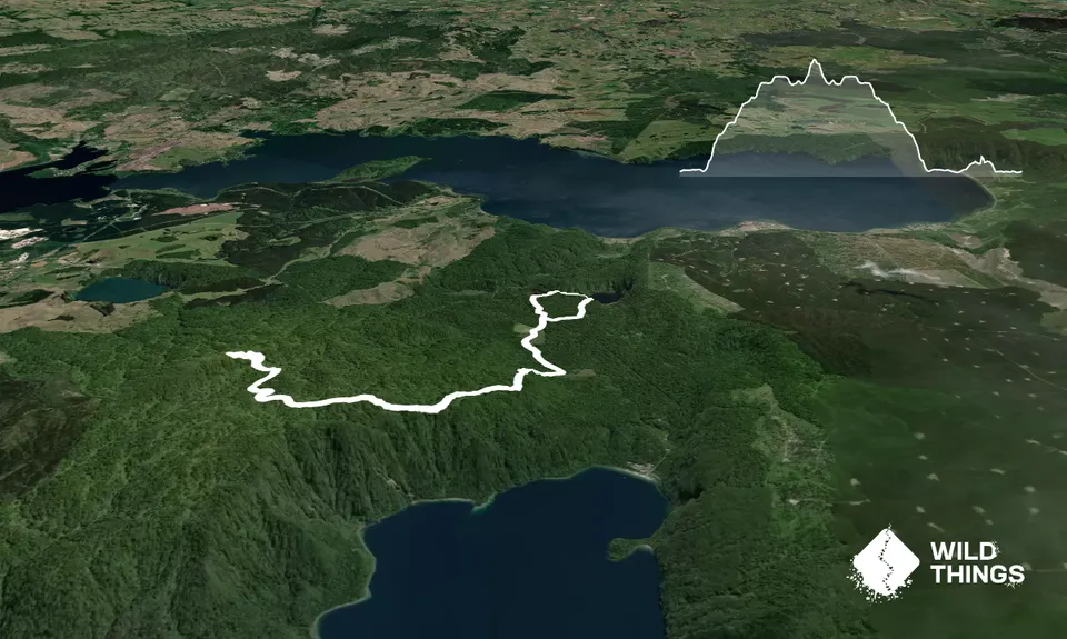
This trail is an out-and-back in one direction to the summit at Rangitoto with some technical climbing, along with a more casual forest loop in the other direction past the caldera lakes. Obviously it can be done in either order, however this describes the route with the summit first.

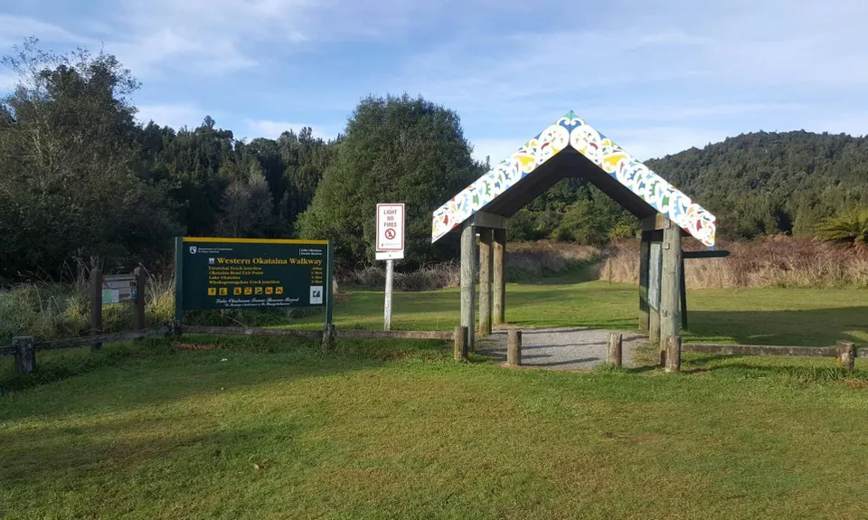
From the signboard near the Outdoor Education Centre head south on the Tarawhai Track. Keep right always, as there will be two forks to the left. The second of these forks will shortly see you climbing into the hills on the Western Okataina Walkway. Eventually you will again come to another fork, where the Western Okataina Walkway continues to the left along the range. Taking another right will take you up to the Rangitoto trig and hopefully some incredible views.

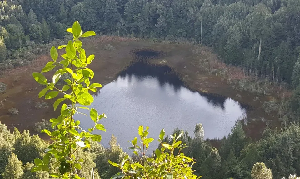
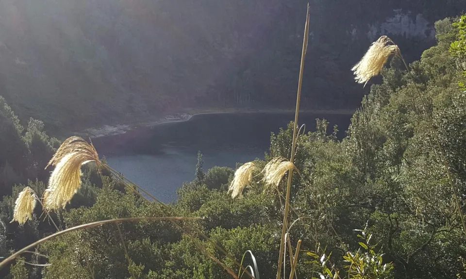
Retrace your steps, then once back at that start follow the access road to Lake Okataina Road. Turn right to follow the road briefly before then taking a left onto the Ngahopua ("The Caldera") track. Be sure to look out for great views of the two very different caldera on your right as you pass them. This track is a simple loop that will take you back to Lake Okataina Road directly opposite the access road that will take you back to the start.

For a variation to this route, coming back down from the summit and hills you can follow the trails south of the Outdoor Education Centre and across Lake Okataina Road onto more trails that then link up with the Ngahopua track - see the NZ Topo Map for more detail.


Trail Community

Find people who are interested in this run.

You must register or login to view this content.

Features of interest

This route summits Rangitoto Peak, the highest point in the Wkakapoungakau Range with great views over parts of Lake Rotorua, Southern Waikato and Western Bay of Plenty on a clear day. It also adds a circuit past the caldera lakes of Rotoatua and Rotongata.


Make Up of Run

Technical Single Track: 25%

Moderate Single Track: 30%

Easy Single Track: 40%

Gravel Road: 4%

Sealed Road: 1%


Route Data

Reviews:

You must register or login to view this content.


Overlapping Runs

The following trails overlap with this run to some degree. You may wish to combine them but please note that to qualify for FKTs on these runs you should record a separate Strava activity for each


Photos:

You must register or login to view this content.

Your Trail Wishlist

All the runs that are on your To Do list (no limit).

Add to wishlist view wishlist

Your Trail Dreamlist

The runs you most want to do (limited to 10).

Add to dreamlist view dreamlist

Wild Explorers

I did it!
  • Access

    The trailhead is from a carpark adjacent to the Okataina Outdoor Education Centre. A short access road is entered from Lake Okataina Road, 4 kilometers down from SH30. While this road is used for access to the Outdoor Education Centre, the public can drive down there and park to access the trail

    There isn't a marked carpark but there is adequate space to park on the grassy area adjacent to the loop at the end of the access road, across from the Outdoor Education Centre buildings and grounds.

    29 km

    31 minutes

    No

    No

  • Staying Safe

    Moderate.

    Generally good.

    Short-sleeved thermal top, Seam-sealed waterproof jacket, Beanie/thermal headwear, Whistle, First aid kit, Extra food for emergencies, Cellphone, Map.

    There are no sources of water on the trail.

    The trail to the summit could be slippery in places in wet conditions, and the area around the trig while not greatly exposed but is likely to be more exposed in high rains or winds.

  • Sponsor this trail

    If you are interested in learning about sponsorship opportunities, please get in touch below:

    Submit

Got a favourite trail? Tell us about it.

Share the love and add your favourite trail(s) to our growing trail directory.

Submit A Trail

Become a member today

Start enjoying the many benefits to becoming a member of our thriving community.

Become a member

Great brands at great prices with our VIP member's discount

Stay up to date

Sign up to our newsletter for latest offers and trail guides

Share this trail with a friend:

VIP Membership

Please register as a VIP or login to your VIP account to view this content.

Cancel Login Register

Membership Required

You can see up to three trail guides without being logged in but after that we require you to be logged in to your Free or VIP account. If you don’t yet have an account you can register here.

Login Register