Last Updated: 7th Dec 2023

Beginner

Save Trail Save

I've done it Done

Thomas River Run

Castle Hill Village, Canterbury

Submitted by Corey Woodward

Last Updated: 7th Dec 2023

Beginner

Save Trail Save

I've done it Done

Open

Grunt Factor: 7 ?

Gnarl Factor: 40 ?

4.7km

110m

110m

819m


Login as a VIP to see driving directions, distance and time.

Trail Map

Type of Run

Front country - easily accessible

Loop

Undulating, small hills only

Native bush

Riverside

Run Makeup

2%
3%
5%
90%

Sealed Road

Gravel Road

Easy Single Track

Moderate Single Track

Average Uphill Gradient: +7.0%

Average Downhill Gradient: -7.1%

Trailhead

Login as a VIP to see the trailhead information.

Estimated Times to Run

0:40

Slow

0:30

Moderate

0:20

Fast

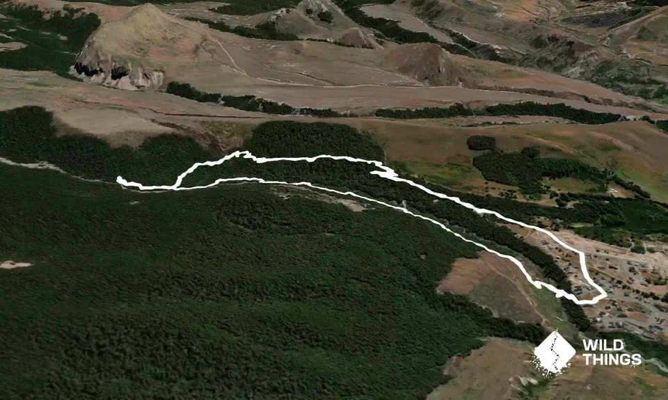
An awesome short loop with well formed trails, delicious native bush, small (easy) river crossings and copious amounts of native birdlife. Start at the DoC sign for the Thomas River trail on Trelissick Loop, head down to the stream and once up onto the terrace head right. Easy to follow trail from there. You will cross over an access road to a Lodge about 900m in, the trail then meanders along above the Thomas River before dropping down to cross the river and briefly send you along a 4WD access track for the Castle Hill Village water scheme.

Take note at the 1.9km mark to look for for a trail to your right as you'll come back to this point and head up there upon your return. The trail gets a bit less travelled from here but eventually brings you out to a massive flying fox (private), from here you get great views up the valley and up to Leith Hill. Now retrace your steps and head up the trail mentioned previously. Eventually the trail will bring you back out to the start of Hogsback track. Follow the gravel road down to Castle Hill Drive and then Trelissick Loop to your start point.

An ideal warm up/shake out for the nearby Leith Hill, Loop of Depression or Hogsback trails without repeating any of those trails (about 100m overlap for trail access).

Plenty of roadside parking opportunities.

0 km

1 minutes

Unknown

No

Easy.

Take note to the return route around the 1.9km mark, it is obvious. Do not attempt to return via a trail marked on some Topo maps from the Flying Fox, it does not exist.

Generally good.

Windproof jacket, Whistle, First aid kit, Extra food for emergencies, Cellphone, Map

Water in the stream/river may be drinkable but advise carrying your own.

Use caution if there has been recent heavy rain, if in doubt about the river crossings don't attempt.

Trail Legend

Christian Couper

Christian Couper

has completed Thomas River Run twice in the last year.

Learn about Trail Legends.

You and Thomas River Run

As a VIP member you can record private notes for this trail, see all of your times and more.

Register Now

Already have an account? Login now

Trail Reviews

Beautiful undulating loop through native bush.

Stefanie Parks

October 21, 2022

A nice wee loop to finish off a day riding the mtb. Would love a crack at that flying fox!

Christian Couper

January 28, 2022

Login to submit a review

Trail Running Community

Find people who are interested in or have completed this trail run.

You must register or login to view this feature.

Register Now

Overlapping Trails

These overlap with this trail to some degree. You may wish to combine them but please note that to qualify for FKTs on these runs you should record a separate activity for each.

Hogsback Track

Hogsback Track

Length: 14.7km

Level: Beginner - Intermediate

Leith Hill

Leith Hill

Length: 8.3km

Level: Intermediate

Cloudsley - Enys Traverse

Cloudsley - Enys Traverse

Length: 21.7km

Level: Very Experienced

The Loop of Depression

The Loop of Depression

Length: 6.0km

Level: Beginner - Intermediate

Other trails nearby
Craigieburn Traverse

Craigieburn Traverse

Length: 43.5km

Level: Experienced

Dracophyllum / Camp Saddle Loop

Dracophyllum / Camp Saddle Loop

Length: 24.0km

Level: Intermediate

Coal Pit Spur Loop

Coal Pit Spur Loop

Length: 15.5km

Level: Beginner - Intermediate

Purple Peak Perpendicular

Purple Peak Perpendicular

Length: 12.0km

Level: Very Experienced

Find more trails and peaks nearby