The Great Pinnacle Experienced
Submitted by Khan Coleman
Front country - easily accessible
Out and Back
Mountainous
Open ridges/topsVolcanic
Experienced
Not Suitable (Slow)
3:20 (Moderate)
2:15 (Fast)
-16.4%
+16.4%
Fastest Known Times (FKTs)
Please set your gender to see your position on the FKT leaderboards.
Men
Women
There are currently no female FKTs for The Great Pinnacle .
Filter FKTs
The more , the harder the FKT will be to beat. Learn about Fastest Known Times.
Description
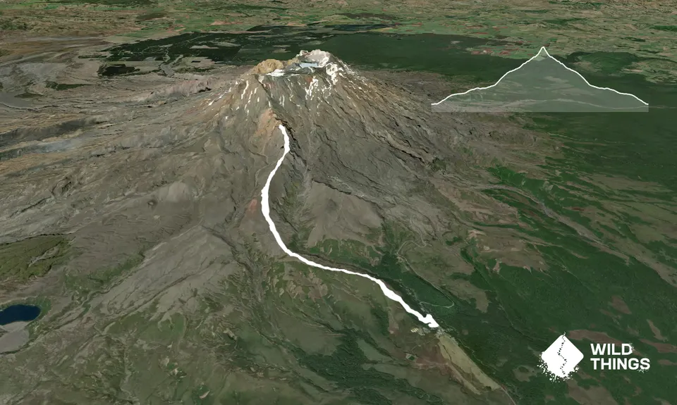
Starting from the Tongariro National Park Visitor Centre, follow the road up for 150m to the start of the Ridge Track. (Maintained DOC track). Follow the Ridge Track up through the beech forest, until you reach the picnic table. From there, look directly beyond the picnic table for a faint ground trail that will lead you on through the vegetation. Follow this up and you should come across a large rock cairn just as you start to break into some patches.
Upon reaching the cairn you can trend slightly towards the right to run along the right hand side of the faint ridge. This will get you out of the vegetation and into the open dirt and scoria. From here you should start to be able to see the main ridge you are aiming for. Keeping the vegetation on your left side so that you remain in the open, pick your way through whilst gradually traversing up and around to the right hand side of a small knoll.
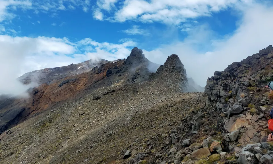
Once around the knoll you should be heading SSE across a fast flat section, beelining it for the main ridge. Upon gaining the ridge proper you should be able to just follow your nose and remain on or near ridge crest most of the way. Any difficulties can be negotiated by turning on either side of the ridge, generally the western (ski area) side is better. The volcanic rock along the ridge is absolutely marvellous and generally of a solid nature.
The final push to the summit involves some scrambling and easy climbing moves, with plenty of options for managing exposure. Give yourself a few moments to enjoy the spectacular views from the summit of the Great Pinnacle, before retracing your steps and returning the way you came. Some care is certainly required while descending from the summit, but once you get back to the less exposed section of the ridge and back onto the nice soft scoria you can start to open it up and have some fun.
Trail Community
Make Up of Run
Untracked / Route only: 91%
Easy Single Track: 8%
Sealed Road: 1%
Route Data
Reviews:
Photos:
Your Trail Wishlist
All the runs that are on your To Do list (no limit).
Add to wishlist view wishlistWild Explorers
I did it!-
Access
Tongariro National Park Visitor Centre
There is plenty of public parking just across the road from the Visitor Centre, as well as various other locations throughout Whakapapa Village.
16 km
12 minutes
No
No
-
Staying Safe
Hard.
Generally good.
Thermal leggings, Long-sleeved thermal top, Seam-sealed waterproof jacket, Gloves, Beanie/thermal headwear, Personal Locator Beacon (PLB), Whistle, First aid kit, Extra food for emergencies, Survival bag, Cellphone, Map, Headtorch and spare batteries, Crampons / microspikes (for winter conditions), Gaiters.
None, take your own.
Snow and ice could exist on the route at any time of year, and the upper part of the route will (almost) certainly be snow/ice covered in winter.
Alpine terrain with rock and icefall potential, wearing a helmet may be a good idea.
-
Sponsor this trail
See other runs nearby:
Round Ruapehu (RTM Track)
Whakapapaiti Loop
Taranaki Falls & Tama Lakes
Ngauruhoe
Tongariro Northern Circuit
Tongariro Switcheroo
Ketetahi Carpark Time Trial
Taranaki Falls Beauty
Whakapapanui Track
Sash and Door Trail
Silica Rapids trail
Ruapehu Mile Higher Club
Tupapakurua Falls
T42 Traverse
Tama Traverse