Last Updated: 28th Apr 2024
Ngauruhoe
National Park, Manawatu - Wanganui
Submitted by Jonathan Cook
Last Updated: 28th Apr 2024
Open
Grunt Factor: 32 ?
Gnarl Factor: 51 ?
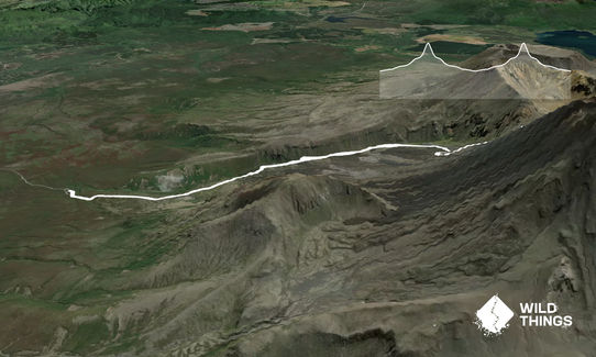
15.2km
1075m
1075m
2241m
Last Updated: 28th Apr 2024
National Park, Manawatu - Wanganui
Submitted by Jonathan Cook
Last Updated: 28th Apr 2024
Open
Grunt Factor: 32 ?
Gnarl Factor: 51 ?
15.2km
1075m
1075m
2241m
Front country - easily accessible
Out and Back
Mountainous
Open ridges/tops
Volcanic
Other
Easy Single Track
Moderate Single Track
Technical Single Track
Untracked / Route only
Average Uphill Gradient: +14.2%
Average Downhill Gradient: -14.4%
VIP Feature: Send this route to your Garmin account so you can follow the course on your Garmin device.
Login as a VIP to see the trailhead information.
4:30
Slow
3:30
Moderate
2:30
Fast
Please note: all peaks in the Tongariro National Park are sacred to the local hapū Ngāti Hikairo Ki Tongariro, who ask that we show respect by not climbing them. Access is not actually banned, so this is a conscience call for all trampers and runners.
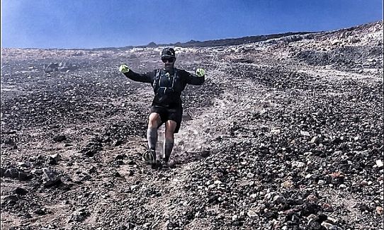
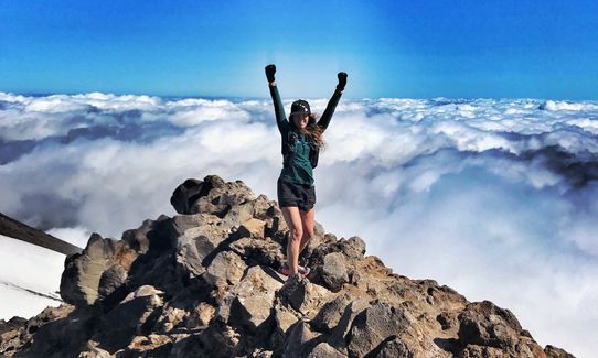
Starting at the car park, run up to the 'Saddle' on the well made trail which alternates between fine gravel, loose rock, sections of boardwalk and flights of stairs. Then scramble up to the crater rim of Ngauruhoe "Mt Doom". You will see a few different paths leading up to the rim. I prefer the steeper rocky ridgeline because its more stable under foot. If you attempt to walk straight up the scree slope, its 3 times harder because for every 3 steps up you slide two steps back. Wear gloves.
Then scree run back down to the saddle, massage cramp out of legs and be thankful you wore gloves for that part because the scoria is sharp and you will be using your hands a fair bit. Once back on the trail, leg it back down to the car park.
You are in the World famous Tongariro National Park; and climbing an active volcano that was filmed as Mount Doom in the Lord of the Rings movie.
If you know of any public toilets near the trail start or on the route, please login and then let us know so we can update this section.
Large busy carpark .
Regular bus drop off/pick up point for hikers walking the Tongariro Crossing.
20 km
22 minutes
No
No
Moderate.
In fine weather no issues.
Heading back down to the saddle could be difficult if the weather closes in causing a white out as navigating back to the trail is very visual dependant.
Generally good.
Waterproof leggings, Thermal leggings, Lightweight fleece top, Long-sleeved thermal top, Seam-sealed waterproof jacket, Gloves, Beanie/thermal headwear, Whistle, First aid kit, Extra food for emergencies, Survival blanket, Cellphone, Compass, Map, Headtorch and spare batteries, Crampons / microspikes (for winter conditions)
Most running water is very clean. you follow a good stream bottom half , but don't drink from the crater lakes!
Sleet, snow, ice and blizzards during winter months.
Exposed to very strong cold winds and heavy rain/sleet on tops at any time of year.
Pick your day carefully regardless of the time of year, because the weather can change very quickly.
The scoria is sharp. Gloves highly recommended for the scree slope.
Trail can be very icy winter months.
my place
Ohakune
because I do it the best
Chateau Tongariro.
bottom of Whakapapa skifield access road. 15min drive
its close and interesting
how far are you willing to drive?
Restaurant at top of the gondola/ National Park/ Ohakune/ Turangi
Trail Legend
Login as a VIP to become a Trail Legend. Learn about Trail Legends.
Fastest Known Times (FKTs)
You and Ngauruhoe
As a VIP member you can record private notes for this trail, see all of your times and more.
Already have an account? Login now
These overlap with this trail to some degree. You may wish to combine them but please note that to qualify for FKTs on these runs you should record a separate activity for each.
Send to your phone
Scan the below QR code to open this trail on your phone.

Tip: position the QR code in your phone camera screen.


