Last Updated: 21st Sep 2023

Intermediate

Save Trail Save

I've done it Done

Block XVI Loop

Upper Hutt, Wellington

Submitted by Jon Peter Hart

Last Updated: 21st Sep 2023

Intermediate

Save Trail Save

I've done it Done

Open

Grunt Factor: 61 ?

Gnarl Factor: 72 ?

27.0km

1460m

1460m

1030m


Login as a VIP to see driving directions, distance and time.

Trail Map

Type of Run

Back country - remote

Loop

Undulating, some big hills

Native bush

Riverside

Open tussock/grasslands

Run Makeup

30%
70%

Moderate Single Track

Technical Single Track

Average Uphill Gradient: +10.1%

Average Downhill Gradient: -10.7%

Trailhead

Login as a VIP to see the trailhead information.

Estimated Times to Run

7:30

Slow

6:00

Moderate

4:30

Fast

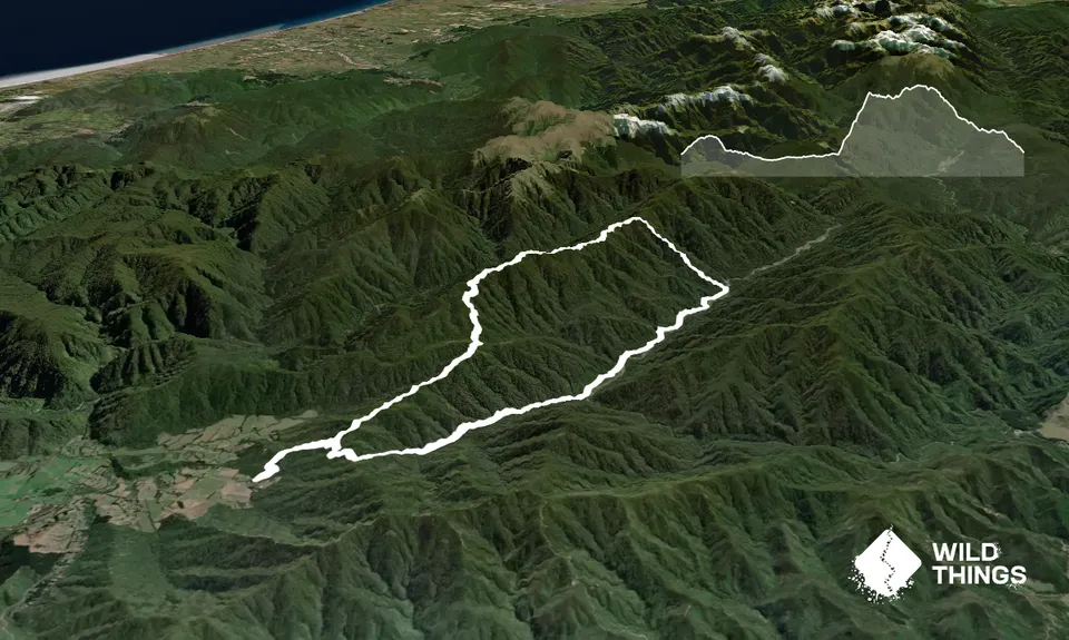
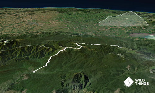
This provides a longer alternative to the Dobson Loop and a shorter alternative to the Kaitoke Omega Loop.

Starting at the carpark head through the bush up the Puffer Saddle. This undulates but gradually climbs over 1.5k until you reach the turn off to Marchant Ridge. Ignore this (unless you want to do the loop in reverse) and keep following the puffer saddle (part of the Dobson loop track). This will take you up over at saddle and down into the Tauherenikau river valley towards Smith Creek at roughly 7km in (ignore the Dobson Loop turn-off unless you want a 12k run instead).

About 1km before Smiths Creek shelter the track splits and you have an option of a track that heads uphill to avoid several slips or the original track. Both of these follow orange markers and for this run I followed the one across the slips (to the right) as they are not that bad and it is quicker. Congratulations, you have just completed the most runable part of the course!

Keep following the track past a Smiths Creek shelter and eventually a cricket pitch sign (not sure the reasoning behind this) and after approximately 1.5km you will reach a junction sign which either sends you right towards a foot bridge over the river or straight towards Block XVI track. Here lies a key decision point. For this run I chose to continue straight (on the left-hand side of the river) towards Block XVI track. The track has orange markers but it also has several major slips and it is very easy to lose the track. I would only recommend this route if you are fairly confident with navigation and have a GPS (it isn't particularly challenging as there is a river on one side and a mountain on the other so its easy to tell if things are going wrong). This track is difficult to run so expect to fast hike sections of it. If you choose the footbridge the track follows the right-hand side of the river and is much easier to run. The down-side with this is you need a GPS to make sure you don't overshoot the Block XVI track start on the opposite side of the river and also the river will be harder to cross after heavy rain. Whichever option you choose you will end up on the Block XVI track which is typical of most Tararua tracks to the tops in that it is steep and seems to go on for ever. The track is approximately 2km and took me 50 minutes of fast hiking to complete (poles would be helpful but not necessary).

At the top you reach a junction where you can turn right to Alpha Hut or left to return to the car-park. At this point you will have likely had enough struggle so reward yourself and head left to the car-park. From here you will be following the Marchant Ridge across Marchant summit and back down to the car-park across roughly 9km's. For the uninitiated, Marchant Ridge feels like every tree root in Wellington has congregated for a conference right in your path and so unless you are superhuman this will be slow going in parts. Don't worry, the last 4km are fairly runnable which makes for a nice end to an emotional roller coaster of a run. Enjoy!

Tauherenikau river, Marchant summit and Marchant Ridge

Parking is available in the car-park at the entrance.

16 km

17 minutes

Unknown

No

Hard.

As above, the main point requiring navigation is between Smiths Creek shelter and the start of Block XVI track. Having a topo map app which has GPS on it to show your position - or the RunHunters app - will make this fairly easy to do.

Patchy.

Long-sleeved thermal top, Seam-sealed waterproof jacket, Beanie/thermal headwear, Personal Locator Beacon (PLB), Whistle, First aid kit, Extra food for emergencies, Survival blanket, Cellphone, Map

Plenty of opportunity to fill up water in the first 12km of the run but no in the second half. Ensure if you are taking water from the river it is a flowing section and look for animal carcasses in the area first.

River may be difficult to cross after heavy rain. Marchant Ridge will be boggy in winter.

River crossings, several slips.

You and Block XVI Loop

As a VIP member you can record private notes for this trail, see all of your times and more.

Register Now

Already have an account? Login now

Trail Reviews

Attempted this overnight in heavy rain and it was an epic mission. River too high to cross so we bush bashed along the true right of the river. Took us over 12 hours which must be a SKT!

Joe Benbow

January 8, 2023

Was an awesome day out in glorious sunshine. I found the Block XVI and Marchant Tracks mostly not runnable due to aforementioned Grunt and Gnarl. Next time I also would take the Tauherenikau East (Left) bank. A plea for adherence to river conventions – left bank is on the left when facing downstream. Thanks!

George Laking

December 30, 2022

Very slow going on the trail on the west side of the Tauherenikau at the moment. I recommend taking the trail along the east side for more running. Good honest climb up to Marchant Ridge going anticlockwise.
I preferred the Omega Loop.

Kate Annan

December 22, 2022

Login to submit a review

Trail Running Community

Find people who are interested in or have completed this trail run.

You must register or login to view this feature.

Register Now

Overlapping Trails

These overlap with this trail to some degree. You may wish to combine them but please note that to qualify for FKTs on these runs you should record a separate activity for each.

Dobson Loop

Dobson Loop

Length: 14.3km

Level: Intermediate

Renata Ridge - Kaitoke

Renata Ridge - Kaitoke

Length: 44.5km

Level: Intermediate - Experienced

Other trails nearby
Tawhai Loop

Tawhai Loop

Length: 7.7km

Level: Beginner - Intermediate

Cannon Point Trig via Zig Zag

Cannon Point Trig via Zig Zag

Length: 5.8km

Level: Beginner

Rimutaka Incline

Rimutaka Incline

Length: 36.0km

Level: Beginner

Karapoti Challenge

Karapoti Challenge

Length: 18.7km

Level: Intermediate

Find more trails and peaks nearby