Wild Things - New Zealand's trail running community
New Zealand's trail running community

Login


don't have an account?

Zampa Traverse, Canterbury

Trail Directory proudly supported by Further Faster

Update Your Header Picture

Zampa TraverseExperienced

Submitted by Nelson Pearson

Info Info
Map Loading

Trail Information

33.44km

2685m

2675m


Canterbury

Hanmer Springs

Front country - easily accessible

Loop

Mountainous

Native bush
Open tussock/grasslands
Open ridges/tops

Experienced

Not Suitable (Slow)
9:00 (Moderate)
6:00 (Fast)

-15.6%

+15.7%

Download PDF Guide

Fastest Known Times (FKTs)

Please set your gender to see your position on the FKT leaderboards.

Men

There are currently no male FKTs for Zampa Traverse.

Women

There are currently no female FKTs for Zampa Traverse.

Filter FKTs

The more , the harder the FKT will be to beat. Learn about Fastest Known Times.

Missing your time?

Register or login as a VIP and get yourself on the FKT leaderboard!

Register Now

Description

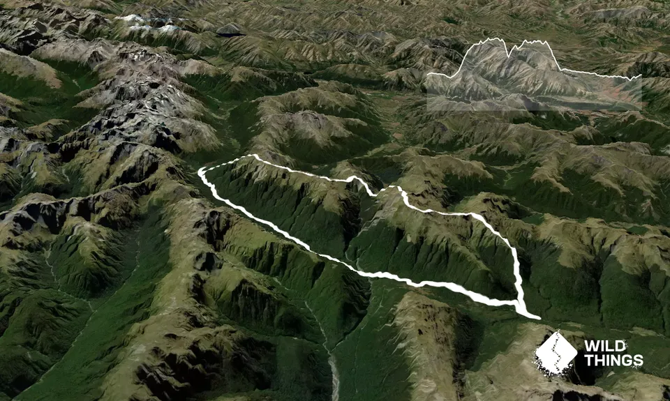
From the Lewis Pass Carpark, travel South on the Rolleston Pack Track for 2-3km, where it finishes on SH7. It can be challenging to find the start of this track, but it is well cut once you're on it. Note that as of 2023, the bridges are still out of action. That said, all the creeks can be jumped without a bridge.

Continue South on the shoulder of SH7 for 400m, looking out for a DOC sign marking the start of Foleys Track on your Left. Take Foleys Track up to the bush line then follow the faint trail up towards Travers Peak. The GPX route does not ascend to Travers Peak, but contours North towards the saddle at 1600m elevation before regaining the ridge at the unnamed saddle between Travers Peak & pt 1690m.

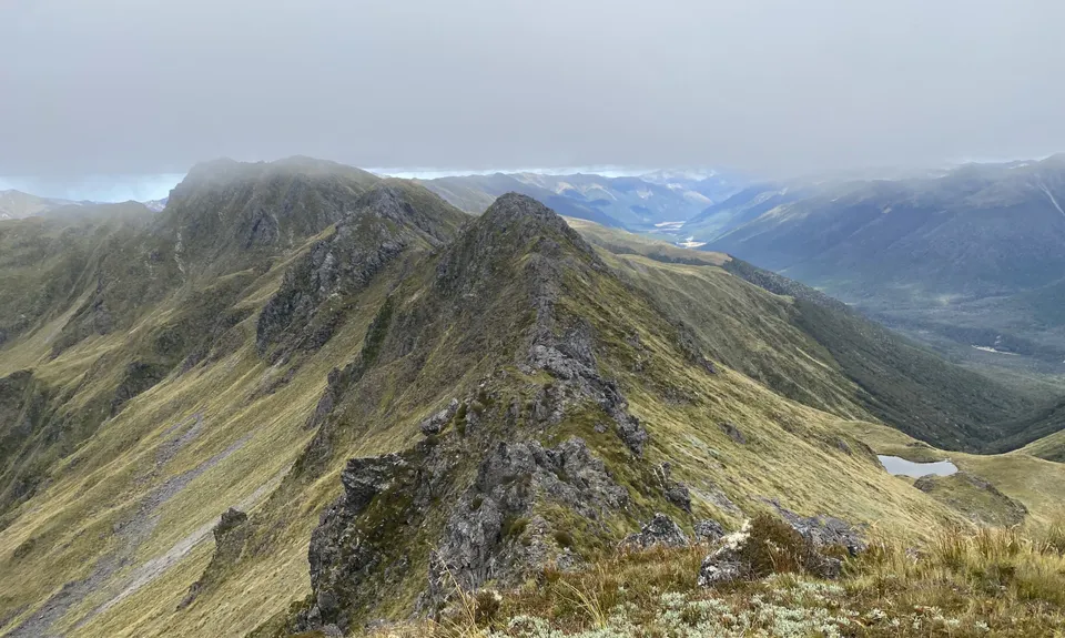
Follow the ridgeline North towards Trovatore, dropping off as needed to traverse below rocky sections. The section between Travers Peak & Trovatore is the most technical on the route.

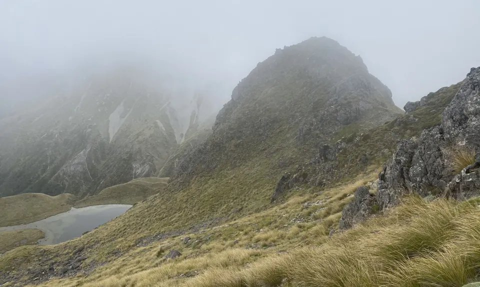
From Trovatore, continue along the ridgeline, past pt. 1723 to 1755, where the trail drops off the main Opera Range & takes the NW spur towards pt. 1724 & Henry Saddle. From pt. 1724, descend the scree sloop to Henry Saddle. Climb North out of Henry Saddle to regain the ridgeline towards Zampa. The upper basins of Zampa have some large tarns that look like good camping spots.

From Zampa, follow the ridgeline North until pt.1681. From here travel North to descend towards Ada Pass along the sometimes narrow spur. From the bush line, bush-bash down until you reach the valley floor, aiming at Ada Pass Hut. Note that the GPX route descends further East than ideal & does a dog leg to Ada Pass Hut. From Ada Pass Hut, follow the clearly marked St James Walkway past Cannibal Gorge Hut to the carpark.


Trail Community

Find people who are interested in this run.

You must register or login to view this content.

Features of interest

Views across the peaks of Lewis Pass & Nelson Lakes.


Make Up of Run

Untracked / Route only: 44%

Technical Single Track: 7%

Moderate Single Track: 9%

Easy Single Track: 39%

Sealed Road: 1%


Route Data

Reviews:

You must register or login to view this content.

Photos:

You must register or login to view this content.

Your Trail Wishlist

All the runs that are on your To Do list (no limit).

Add to wishlist view wishlist

Your Trail Dreamlist

The runs you most want to do (limited to 10).

Add to dreamlist view dreamlist

Wild Explorers

I did it!
  • Access

    The route starts & finishes at the Lewis Pass carpark & shelter. This is the Northern trailhead of the St James Walkway.

    There is a parking lot at the start/finish.

    0 km

    0 minutes

    No

    No

  • Staying Safe

    Hard.

    Start - The start of the Rolleston Pack Track can be challenging to find.
    pt.1755 - don't follow the Opera range, be sure to travel towards Henry Saddle.
    pt. 1681 - be sure to drop off the ridge tops here towards Ada Pass Hut.

    Non-existent.

    Lightweight fleece top, Long-sleeved thermal top, Seam-sealed waterproof jacket, Beanie/thermal headwear, Personal Locator Beacon (PLB), Whistle, First aid kit, Extra food for emergencies, Survival bag, Cellphone, Compass, Map, Crampons / microspikes (for winter conditions), Gaiters.

    Many tarns along the ridgeline. May be snow, depending on the season.

    Much of this route is in the Sub-Alpine, so will require snow skills in winter.

    Weather - much of this route is on a relatively exposed ridgeline. Best to avoid high wind or poor visibility.

  • Sponsor this trail

    If you are interested in learning about sponsorship opportunities, please get in touch below:

    Submit

Got a favourite trail? Tell us about it.

Share the love and add your favourite trail(s) to our growing trail directory.

Submit A Trail

Become a member today

Start enjoying the many benefits to becoming a member of our thriving community.

Become a member

Great brands at great prices with our VIP member's discount

Stay up to date

Sign up to our newsletter for latest offers and trail guides

Share this trail with a friend:

VIP Membership

Please register as a VIP or login to your VIP account to view this content.

Cancel Login Register

Membership Required

You can see up to three trail guides without being logged in but after that we require you to be logged in to your Free or VIP account. If you don’t yet have an account you can register here.

Login Register