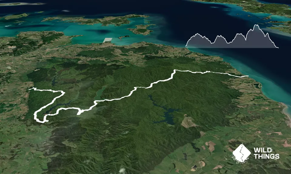
For most Auckland Trail runners the Hunua Ranges is the girl next door that you've never really took much notice of. Stop being so shallow, she's got a great personality.
Massey Track 3km, 30 minutes. Trail is well groomed with a lot of climbing:
Parking at the Hunua Falls. Grab some water, this is the only potable water for the whole length. Cross the foot bridge and turn left. You'll get to an intersection: the start of the Cossey-Massey loop. You can go either way around the loop, I suggest right, going left you start with a stream crossing and also part of the track is washed out (Oct 2017) so has a road detour. Going right: There is a solid climb, don't go down the Camp Adair track, keep going, near the top is turn off for the Wairoa Cossey Track.
Wairoa Cossey Track 5.5km, 1hr 15min. Undulating, technical, muddy:
Unless you are Kilian Jornet, I'd forget about trying to run the first half of this section, the going is tough. You'll get to a half way sign, don't worry it gets better. Track gets a little more runnable and a gradual downhill. You'll soon reach the Suspension Bridge Loop.
Suspension Bridge Loop 1km, 8 min. Groomed fast downhill:
The first junction you reach along the Cossey-Wairoa track, you can go either way. Stick right to go across the cool old suspension bridge, then you'll come to a road.
Wairoa Loop Climb, 3.5km, 35min. Groomed with a solid uphill:
Wairoa Loop is officially closed due to a slip (Oct 2017 so you COULD detour by turning right after the suspension bridge, going along the road past the information sign, then turn left up Moumoukai Road which will take you all the way up then down in to the Mangatawhiri Valley). Seriously, the slip is pretty easy to get around so I would just jump across the tape. So turn left after the bridge, go along the road until you get near the Wairoa dam, then you'll see the Wairoa Loop track, sign posted, on your right. You'll get to a Radio repeater at the top (Repeater Campground).
Drop in to Mangatawhiri Valley, 4km, 20min. Metaled road, all gradual downhill:
From the repeater, follow the metaled road it joins up with Moumoukai Road, where you turn left to drop down in to the valley. Watch out for cars full of crazy mountain bikers. Follow the road until you get to the sign for the Mangatawhiri carpark on your right, where you'll come across the first set of toilets since you headed off. Well done, you are half way.
Liburne Road, 5km, 50minutes. Metaled road, long steady climb.
From the car park keep following that road around, you'll come to a gate, go through then up the sort climb to the top of the dam. Walk across the dam and follow Liburne road. There are various trails that turn off this road. Keep going to the end of the road and you'll reach Piggott's campground, which has a hut and a long drop.
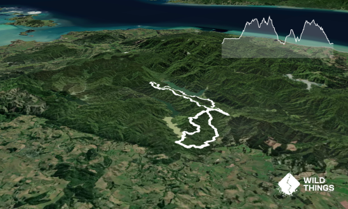
Mangatangi Ridge Track, 6km, 1hr 30min. Moderately technical with LOTS of climbing:
Just past Piggott's the Mangatangi Ridge Track is signposted (Upper Mangatawhiri is an alternative option). It starts out easy and flowing (this is part of the Rata Ridge Loop), you turn left after about 1.5km and drop down to a stream, cross and start climbing up the other side. The climb is a steep grind on unformed trail that goes on for approximately forever. Keep on putting one foot in front of the other and you might reach the top, at which point there is more uphill but just not as steep. You'll eventually reach an intersection. You can go straight ahead (north) for a short detour to Kohukohunui, Auckland's highest point.
Kohukohunui down to Waharau. 7.5km, 1hr. Some steep and technical downhill becoming groomed and gradual downhill:
Mangatangi Ridge track meets up with Kohukohunui Trig Track. You can detour north for a few hundred meters along the K' Trig track to reach a lookout at Auckland's highest point, its well worth the extra 1km or so. To get to the bottom, turn right at the intersection, through two large rocks, to keep following the Mangatangi Ridge track down. At first some parts are steep. You'll reach a small stream crossing and the Thousand Acres Campground. Follow the dirt road, it climbs for a while (the last real climb!) before meeting up with the Waharau ridge track, then turn right. You'll come to another intersection that offers two ways down, turn left for the shorter route and follow the red markers. You'll come out at a picnic area, go through the little gate and down the road a bit more to find yourself at the main Blackberry Campground. There are BBQ's and a stream to soak your aching legs in.