This is a mammoth run, and a variant of the existing Kaimanawa Killer trail - removing the run along the gravel road (so you'll need two vehicles) and adding in extra trails in the bush.
After planning your shuttle at the end (or stashing a bike...), starting at Te Iringa campsite, head south following the Te Iringa track, up and over Te Iringa (this is a solid climb), before you then reach the Kaipo River (and bridge). From here, continue south, signed to Oamaru Hut. This track follows the river until you reach the hut, with stunning views across the valley.
From here, follow the DoC sign to Boyd Hut - you'll cross some open paddocks for a few kilometres before heading back into the bush. Eventually you'll reach a DoC signed junction a the Maungaorgani / Boyd Hut junction. This route takes the west route, up the Maungaorgani track.
If you're splitting this route into an overnighter, this would be a great point to head to Boyd Hut for the night, adding in an extra 5-6km each way (out and back from this junction)
Note, the Maungaorgani Track has been reclassified by DoC as a 'route' - so expect a rugged, technical, less-used route, and be prepared to use your navigation skills - although it is still marked with orange triangles and poles across the tops. It is a brutal climb straight up for 2km, but once you reach the 1254 high point, it settles down a bit before you are awarded with utterly epic views as you break the tree line and reach the open tops and summit of Maungaorangi.
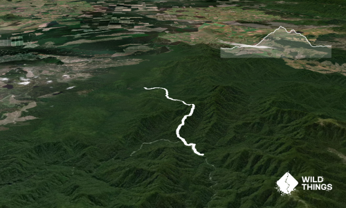
Continue down the other side until you reach Cascade Hut.
From Cascade Hut, you follow the Into Cascade route, and after a section of beautiful track that follows the river, you're into your last solid climb of the day. Grab some water from the streams before you start the climb, as there's none until you're back down the other side.
The last first three-ish km are fairly easy going, following the river before you start a solid climb up.
Keep an eye out for Sika Deer and Whio. There are stunning campsites and of course, huts along the route, so it can be easily split into a multiday fastpack or hike.
Long drops at start, finish and at each hut along the way.
The first section of Clements Mill Road to Te Iringa campsite is good. Beyond that, if you are dropping a second car or bike at the finish, you'll need to drive to the very end of Clements Road. 4WD is not necessary, but ground clearance on your car is - it's rutted out in a few places.
40 km
36 minutes
With Permit
No
Hard.
It is a challenging trail, and one that shouldn't be undertaken solo for safety reasons unless you are extremely experienced and prepared for an overnighter.
This is dense bush with no cellphone coverage, so it is of the utmost importance to stay on track. It is NOT recommended to attempt this trail during darkness or in poor weather with poor visibility. The route is often very slow to navigate, with steep climbs, fallen trees to clamber over/under and very rooty terrain underfoot.
Plenty of streams and rivers, but none on the long climbs so fill up before each climb. It's recommended to filter the stream water.
Expect snow across the Maungaorangi tops in winter. Strong winds would make it dangerous in some areas due to tree falls, and heavy rain would make rivers impassable.
Be mindful of the rivers—they are large and can become impassable after significant rain. Also, do not attempt in high wind as there may be tree fall across the top.
Do you have a suggestion on where to go afterwards for the best coffee / cake / breakfast / brunch / beer?
These overlap with this trail to some degree. You may wish to combine them but please note that to qualify for FKTs on these runs you should record a separate activity for each.
We don't store or share your location; it's only used for these features. You can continue without it, just without distance sorting and live map features.
Send to your phone
Scan the below QR code to open this trail on your phone.
Tip: position the QR code in your phone camera screen.