The track is designed for mountain biking so is a generally flat surface in good condition. In the final 5 or so kilometres you can come across some short muddy sections.
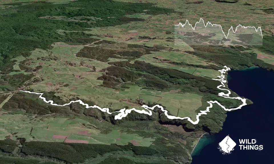
This is a beautiful track that does not pose too many challenges through the surface or undulations. As it is intended for mountain bikers the climbs are gentle and include many switchbacks. After the Waihaha waterfall look out at 7km and there are toilets and vehicle access at approx 12km. After this access point the trail twists and turns its way through bush occasionally popping out on a bluff over the lake edge. The track is very clearly marked. The lake and mountain views are spectacular and there is always a seat to rest on! Except for when you on a bluff you are mostly under tree cover.
The track initially follows a stream
If you know of any public toilets near the trail start or on the route, please login and then let us know so we can update this section.
Parking is remote but quite safe, I did this as a point to point run as a group. We got dropped off at the start point after leaving vehicles in Kinloch and then at the finish used a water taxi to get back to our cars. The finish point is only accessible by water taxi - or you could run back out!
The final 5km has patches of mud. Boardwalks/bridges are common towards the end which would be very slippery when wet. Make sure you carry sufficient water and warm clothes as you are isolated and the temperatures can drop and be very low.
In the past there have been some slips on the track however, a maintenance crew regularly maintains the condition and water taxi staff would have update information.
Do you have a suggestion on where to go afterwards for the best coffee / cake / breakfast / brunch / beer?
These overlap with this trail to some degree. You may wish to combine them but please note that to qualify for FKTs on these runs you should record a separate activity for each.
We don't store or share your location; it's only used for these features. You can continue without it, just without distance sorting and live map features.
Send to your phone
Scan the below QR code to open this trail on your phone.
Tip: position the QR code in your phone camera screen.