Last Updated: 21st Sep 2023
Hunters Hut Mission
Last Updated: 21st Sep 2023
Open
Grunt Factor: 58 ?
Gnarl Factor: 76 ?
20.5km
1620m
1620m
1519m
.jpg?tr=w-542,h-325)
.jpg?tr=w-542,h-325)
.jpg?tr=w-542,h-325)
.jpg?tr=w-542,h-325)
.jpg?tr=w-542,h-325)
Last Updated: 21st Sep 2023
Last Updated: 21st Sep 2023
Open
Grunt Factor: 58 ?
Gnarl Factor: 76 ?
20.5km
1620m
1620m
1519m
Back country - remote
Out and Back
Mountainous
Dog Friendly
Native bush
Open tussock/grasslands
Open ridges/tops
Gravel Road
Moderate Single Track
Technical Single Track
Untracked / Route only
Average Uphill Gradient: +17.6%
Average Downhill Gradient: -17.6%
VIP Feature: Send this route to your Garmin account so you can follow the course on your Garmin device.
Login as a VIP to see the trailhead information.
6:00
Slow
4:00
Moderate
3:30
Fast
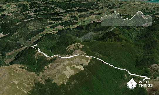
Locate the start of the track as detailed above. It starts with some nice single track, through bush, before coming out into open terrain with wonderful 360 views of various ranges, mountains and sea. This track is one of Nelson's best kept secrets.
The obvious track gives way to orange markers and very rocky terrain, not all of it run-able, and some steep climbs which can be very windswept. The geologists will enjoy the various rock forms, which are also quite unforgiving for dog feet and runners' knees should you trip.
At the top of the ridge you will see the markers veer left, follow these along and then down through open grasses and scree, where the track enters a large area of native bush. Watch for native falcons and wekas. The track is steep and technical in parts, as it plunges all the way down to the Motueka River Left Branch below, you will be aware the entire descent that this will be a challenging climb on the way home.
At the river, then follow the sign left through bush to Hunters Hut (described as a 45 minute walk). Soon the track will direct you across the river. Keep your eyes peeled for the orange triangles along the river's edge, as there are a couple more river crossings to go, before heading back into the bush (on the opposite side of the river from whence you came) for a final wee grunt up through native bush to Hunter's Hut. Then reverse the process to get home, allow a bit longer to get back - the climb back up through the bush makes this a difficult run to negative split.
"Situated at the south western edge of the Mt Richmond Forest Park, the Red Hills are a unique ultramafic geological area composed of very dense magnesium-rich rocks which have been thrust up at least 10 km or more from below the earths crust. The soils derived from these magnesium-rich rocks are too toxic for tree growth so much of the area is covered in distinctive scrub and tussock. This ultramafic area runs from Ben Nevis in the north approximately 20 km south to State Highway 63.
The Red Hills has low to moderate red deer numbers which tend to stay within the forested areas more than the ultramafic.
Goats can also be encountered throughout the area and the support of recreational hunters in controlling these animals in this fragile environment would be much appreciated.
The odd pig may show up in the forested area but their numbers are generally low."
From: http://www.doc.govt.nz/parks-and-recreation/things-to-do/hunting/where-to-hunt/nelson-tasman/nelson-lakes-hunting/where-to-hunt/red-hills/
If you know of any public toilets near the trail start or on the route, please login and then let us know so we can update this section.
There is no public transport. Car parking is remote and probably safe. This is a lesser known track.
50 km
46 minutes
Yes
No
Hard.
Make sure you stay alert for the orange markers along the ridge lines and the triangles along the river. Take a Topo Map: NZTopo50-BR25 (Tophouse).
Hunters Hut is located at Grid/NZTM2000 coordinates: E1600210, N5394711
Very patchy.
Waterproof leggings, Thermal leggings, Long-sleeved thermal top, Seam-sealed waterproof jacket, Gloves, Beanie/thermal headwear, Personal Locator Beacon (PLB), Whistle, First aid kit, Extra food for emergencies, Survival bag, Cellphone, Compass, Map, Headtorch and spare batteries, Crampons / microspikes (for winter conditions)
Carry your own water. Can get hot along the tops in summer due to sun/heat reflecting off the rocks.
In winter there is a high chance of snow along the tops, it can also be very exposed and windswept, on unstable rocky ground. The Motueka River can be prone to flooding, in which case you would not be trying to cross it to reach Hunters Hut. A DOC hut was swept away a few years ago, sadly resulting in two fatalities. There is reference to this in Hunters Hut.
See seasonality issues.
The Wakefield Bakery
12 Clifford Road, Wakefield, 7025
http://www.wakefield.org.nz/listing/wakefield-bakery/
Excellent meaty pies and evil sweet things.
Fastest Known Times (FKTs)
You and Hunters Hut Mission
As a VIP member you can record private notes for this trail, see all of your times and more.
Already have an account? Login now
I loved this run, definitely a mind game going down through the forest knowing you would be coming back up again.
September 11, 2022
Send to your phone
Scan the below QR code to open this trail on your phone.

Tip: position the QR code in your phone camera screen.


