Last Updated: 21st Sep 2023

Intermediate

Save Trail Save

I've done it Done

Akatawara Saddle to Otaki Forks

Waikanae, Wellington

Submitted by Emily Shrosbree

Last Updated: 21st Sep 2023

Intermediate

Save Trail Save

I've done it Done

Open

Grunt Factor: 29 ?

Gnarl Factor: 31 ?

27.7km

500m

800m

827m


Login as a VIP to see driving directions, distance and time.

Trail Map

Type of Run

Front country - easily accessible

Point to Point (one way)

Undulating, some big hills

Native bush

Other

Run Makeup

60%
20%
20%

Farm Road / 4WD Track

Moderate Single Track

Technical Single Track

Average Uphill Gradient: +9.1%

Average Downhill Gradient: -9.6%

Trailhead

Login as a VIP to see the trailhead information.

Estimated Times to Run

4:30

Slow

3:15

Moderate

2:00

Fast

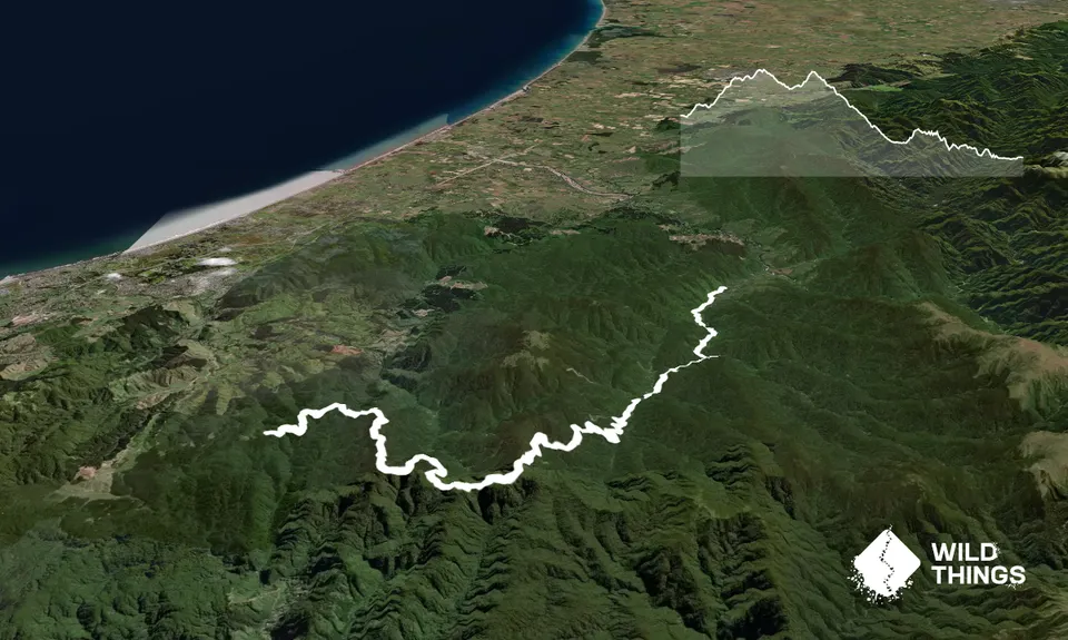
From the Akatawara Saddle, head up the Waiotauru Road (a steep 4WD track). This winds upwards for a while and can be very steep in places. As it flattens out you'll pass Point 764, 772 and 882 (Kakanui).

After about 10km you'll reach Maymorn Junction by which point you'll have already started descending. Take care to take identify the right path here. You want the 4WD track that heads roughly north, and downhill. At this junction there are two tramping tracks, one which goes to Kapakapanui Hut and one to Renata Hut. You don't want either of these.

For the next 8-9kms you'll be working your way gently down to Waiotauru Hut, which is 4WD track all the way, although in some sections it is very rough and steep. At one point there are a couple of abandoned vehicles which didn't make it. Waiotauru Hut isn't the nicest spot, so I wouldn't recommend planning to stop here. Just beyond the hut cross the Southern Waiotauru River at the obvious fording point and follow the 4WD track to the left.

Keep following the 4WD track roughly alongside the river. After a kilometre or so you'll need to drop down to the left to cross an incoming side stream (you'll know very soon if you've missed this point as the track comes to a river cliff that you will not want to try descending!). A few metres up the side stream you'll pick up some orange triangles which mark the track off to the left. Follow this up a short way, then continue along it as it sidles it's way towards the swing bridge at Waiotauru Forks.

Just before the bridge, there's some open grass, keep left to find the track that zig zags down to the bridge itself. Once over the bridge just follow the track, marked with orange triangles, all the way out to Otaki Forks. It's a good track although sometimes a little rough underfoot. There are a couple of slips to cross along the way, so take care to pick a path across these. Arrange for somebody to pick you up from the very end of the road at Otaki Forks (not the Warden's House carpark).

There's a parking area at the saddle on the Akatawara Road. Not sure of the safety of leaving a car here, so would advise getting dropped off if you can.

12 km

19 minutes

Unknown

No

Moderate.

Take particular care at Maymorn Junction and after fording the river just after Waiotauru Hut.

Non-existent.

Thermal leggings, Long-sleeved thermal top, Seam-sealed waterproof jacket, Windproof jacket, Gloves, Beanie/thermal headwear, Personal Locator Beacon (PLB), Whistle, First aid kit, Extra food for emergencies, Survival bag, Cellphone, Map, Headtorch and spare batteries

Water can be sourced from the Waiotauru or Otaki rivers.

Watch the weather as river crossings are involved.
Also, slips may have changed after heavy rain.

Given there are a couple of river crossings, this is not a run to do in heavy rain unless you want to climb back up to the Akatawara Saddle.
There can be the odd vehicle on the 4WD sections of the route.
There are a couple of slips on the last section alongside the Otaki River. Take care crossing these.

The Perching Parrot
Paekākāriki

You and Akatawara Saddle to Otaki Forks

As a VIP member you can record private notes for this trail, see all of your times and more.

Register Now

Already have an account? Login now

Trail Reviews

Be the first to submit a review for Akatawara Saddle to Otaki Forks !

Login to submit a review

Trail Running Community

Find people who are interested in or have completed this trail run.

You must register or login to view this feature.

Register Now

Overlapping Trails

These overlap with this trail to some degree. You may wish to combine them but please note that to qualify for FKTs on these runs you should record a separate activity for each.

Big Circuit Run

Big Circuit Run

Length: 51.6km

Level: Intermediate - Experienced

Goblins Gander

Goblins Gander

Length: 37.0km

Level: Intermediate - Experienced

Other trails nearby
Renata Ridge - Kaitoke

Renata Ridge - Kaitoke

Length: 44.5km

Level: Intermediate - Experienced

Kapakapanui Loop

Kapakapanui Loop

Length: 13.0km

Level: Intermediate - Experienced

Mangaone Return

Mangaone Return

Length: 14.0km

Level: Beginner - Intermediate

The Whole Hemi

The Whole Hemi

Length: 6.5km

Level: Intermediate

Find more trails and peaks nearby