Goblins GanderIntermediate - Experienced
Submitted by Rosie Rochester
Front country - easily accessible
Loop
Very hilly
Native bushRiversideOpen ridges/tops
Intermediate - Experienced
Not Suitable (Slow)
7:30 (Moderate)
5:00 (Fast)
-10.5%
+10.7%
Fastest Known Times (FKTs)
Please set your gender to see your position on the FKT leaderboards.
Men
Women
There are currently no female FKTs for Goblins Gander.
Filter FKTs
The more , the harder the FKT will be to beat. Learn about Fastest Known Times.
Description
NB The time estimates are moving time so allow another few hours if you are keen to stop and enjoy the amazing views.
Head up the track on the right of the info board/maps. Turn left at the first sign following the arrow to Waiotauru Hut. It's a lovely runnable undulating track that passes by historic relics from the days when they milled the forest of its ancient trees. There's a few narrow sections that pass over slips where extreme care is needed, stunning views over the river and forest in these spots though! Birds abound in the bush, we saw two morepork, tomtits, grey Warblers, Tui, kereru and of course fantails always love to come along for the run!!!
Not long after the swing bridge the trail widens out to a 4WD track. This continues to Waiotauru hut. There's a couple of places where the track detours off down to the right as some areas 4WD vehicles can't pass. These are actually off the walking track and it can be a little bit confusing so check your map or navigation app if you are in doubt.
There's one side stream crossing where you follow the orange markers, and you cross the main stream at the site of a demolished old rusty bridge, (this shows as a bridge on the map). A few hundred metres up the 4WD track at approximately 12km you'll arrive at the hut, recently rebuilt, and the pile of rubble from the old vandalised one is still next to it. From here carry on up the 4WD track and its a steady and mostly gentle (with some pinches) but runnable climb (fitness dependant) uphill 6km to Maymorn junction.
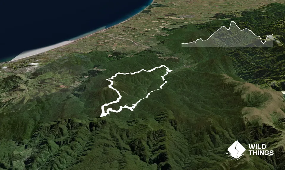
There's a signpost here, follow the arrow to Kapakapanui Hut, its 6.5km, and is absolutely mind-blowing mossy green scenery through Goblin forests. There's a pretty meaty, rooty climb up to the tops, and then you'll pop out into the open with ever changing terrain, rocks and scrub, and then back into rooty Goblin forest sections.
120 metres before Kapakapanui Hut you'll see a huge orange triangle - this is the start of the unmarked route across the saddle to the Pukeatua Track. A quick detour down to the hut gives you a last chance to refill water. The unmarked route across the saddle is around 2km, and can take about an hour to walk (mostly too tricky to run). There's a fair amount of bushbashing, climbing over logs, bush lawyer, mud (See Navigation Tips info for this route below). It's great fun, with beautiful views at spots along the way of the Kapiti coast and island.
You'll arrive back on to track at the orange triangles where you turn right onto Pukeatua track, which is a stunning run all the way back to Otaki Forks. At the high spot of Pukeatua if you are lucky you can see Mt Taranaki & Mt Ruapehu. Breathtaking!
Trail Community
Features of interest
Near the beginning of the run you pass this historic steam powered sawmill at Sheridan Creek. This operated from 1930 to 1938. It was a shoestring operation and worker safety was not a priority. But during the depression employees were pleased to have a job. Logs were brought down a bush tramway by a rail tractor, the route included the steepest grade (1 in 5) recorded on a bush tram. There were several accidents. The operation closed unexpectedly in 1938 when a flood washed out the bridges. Much has survived and it is a relatively complete timber industry heritage site. The site is managed as a remote experience ‘discovery’ site. Restoration work has included the rust arrest of the log hauler and timber mill boiler. Two sections of original tramway have been excavated, placed onto new sleepers and treated with metal preservatives. The turntable has also been rebuilt.
Make Up of Run
Untracked / Route only: 5%
Technical Single Track: 20%
Moderate Single Track: 25%
Easy Single Track: 30%
Farm Road / 4WD Track: 20%
Route Data
Reviews:
Overlapping Runs
The following trails overlap with this run to some degree. You may wish to combine them but please note that to qualify for FKTs on these runs you should record a separate Strava activity for each
Photos:
Your Trail Wishlist
All the runs that are on your To Do list (no limit).
Add to wishlist view wishlistWild Explorers
I did it!-
Access
Drive right to the end of Otaki Gorge road. It's around 20km inland from Otaki Township. There is an info board here, large gravel carpark, and a long drop toilet. If you prefer a flush toilet stop at the carpark before this one, this is also where the DOC rangers' house and intentions book is (always a good idea to fill this out)
20 km
26 minutes
No
No
-
Staying Safe
Hard.
A a navigation app on your phone is highly advised.
When you are following the unmarked route across the saddle from the large triangle on the tree BEFORE Kapakapanui Hut across to meet the Pukeatua Track there is quite a bit of bush bashing. At times you can follow a light footbed, but mostly you are finding your own way. There is different coloured tape on trees from time to time but it's extremely erratic. Its not difficult, its just important to stay on the saddle and not veer off either side downhill, this is where your navigation app is hands down the best thing to check from time to time!! Otherwise follow your compass bearing. Watch out near the end for the large orange marker & smaller triangles, this is Pukeatua Track. Turn right and follow this track back to the forks.Very patchy.
Thermal leggings, Lightweight fleece top, Short-sleeved thermal top, Long-sleeved thermal top, Seam-sealed waterproof jacket, Gloves, Beanie/thermal headwear, Whistle, First aid kit, Extra food for emergencies, Survival bag, Cellphone, Compass, Map, Headtorch and spare batteries.
Plenty of access to water in the stream and two huts.
Large muddy patches year round.
This involves tops travel, be prepared for EXTREME cold weather. Even in summer, be prepared for worst case scenario, don't skimp on warm layers and plenty of food, and take a torch. It is soooo beautiful that with photo stops, and checking out the huts, and the amazing Goblin forests, time does get away on you, so during autumn/winter it's easy here to run out of daylight hours.
The time estimates are moving time so allow another few hours if you are keen to stop and enjoy the amazing views.This involves tops travel, be prepared for EXTREME cold weather. Even in summer, be prepared for worst case scenario, don't skimp on warm layers and plenty of food, and take a torch.
-
Sponsor this trail