Last Updated: 7th Oct 2024
Waiotahi Karaka Trail
Last Updated: 7th Oct 2024
Grunt Factor: 21 ?
Gnarl Factor: 44 ?
12.4km
570m
590m
592m
Last Updated: 7th Oct 2024
Last Updated: 7th Oct 2024
Grunt Factor: 21 ?
Gnarl Factor: 44 ?
12.4km
570m
590m
592m
Front country - easily accessible
Combo
Very hilly
Dog Friendly
Native bush
Riverside
Easy Single Track
Moderate Single Track
Technical Single Track
Average Uphill Gradient: +9.1%
Average Downhill Gradient: -9.4%
VIP Feature: Send this route to your Garmin account so you can follow the course on your Garmin device.
Login as a VIP to see the trailhead information.
3:30
Slow
2:20
Moderate
1:45
Fast
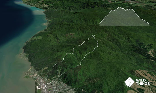
Starting at the Waiotahi gate, the trail works its way up past an old quarry, before the climb really starts to kick in! Winding its way up the hill, you'll find the trail crossing the Waiotahi stream multiple times. If there's been a bit of rain, just be aware the track can get quite muddy in places, however, the stream crossings are very small, so it shouldn't be a problem.
As you climb higher, keep an eye out for some gorgeous views out over the firth, and down into the valleys on either side. The trail is mostly covered in native bush, so it isn't too exposed. After climbing up and over the highest point, you'll start heading slightly downhill, until about roughly 6.3km in, where you'll come to your first track junction. This DOC signpost shows that heading north would take you towards the Kauaeranga and Crosbies Hut, however, you'll be heading south, which is signposted for the Karaka.
The next 1.6km of the trail is quite technical and slow going, as you wind your way along the side of the hill, before eventually emerging at the Red Cliffs. This is a great spot for a snack break where you can admire the views out into the Kauaeranga Valley, all the way down the Kaimai Ranges, and out over the Hauraki Plains. After this, you're onto the downhill segment. Recent trailworks have seen this section of trail widened and regraded, so it makes for a good opportunity to open the legs up, and enjoy all your hard work!
After crossing the Karaka Stream, the trail follows the stream down past some great little swimming holes. You'll cross over a few bridges, before finally emerging at the Karaka Car Park. If you're unable to get a pickup, you can loop back to the start of the Waiotahi via the monument.
The Waiotahi side of the trail follows an old mining access road. If you keep your eye out you'll notice lots of old mines, workings, and old settlements on the climb. Through the middle section of the trail you'll come to the 'Red Cliffs'. Here the track is benched into the side of the rocks, which due to mineral deposits are a striking red colour. On the way down the trail meets up with and follows the Karaka stream, so keep an eye out for some of the local swimming holes on your way down.
If you know of any public toilets near the trail start or on the route, please login and then let us know so we can update this section.
There is a small gravel parking bay just off the side of the road by the gate.
0 km
0 minutes
Yes
No
Easy.
The only navigation point is the track juntction to Crosbies Hut, about 6.3km into the track. The DOC signpost shows that heading north would take you towards the Kauaeranga and Crosbies Hut, however you'll be heading south, which is signposted for the Karaka.
Patchy.
Long-sleeved thermal top, Seam-sealed waterproof jacket, Whistle, First aid kit, Extra food for emergencies, Survival bag, Cellphone, Map
It's best to take your own water for the length of the trip. If the weather has been calm, the water in the creeks should be drinkable, but it would be best not to rely on that.
The trail gets quite muddy after a bit of rain. Keep in mind there are several small creek crossings which aren't bridged, so the water may come up after long periods of rain.
Trail Legend
Login as a VIP to become a Trail Legend. Learn about Trail Legends.
Fastest Known Times (FKTs)
You and Waiotahi Karaka Trail
As a VIP member you can record private notes for this trail, see all of your times and more.
Already have an account? Login now
There are many slips present, most especially on the Waiotahi trail - please take care until these slips have been repaired.
October 30, 2023
These overlap with this trail to some degree. You may wish to combine them but please note that to qualify for FKTs on these runs you should record a separate activity for each.
Send to your phone
Scan the below QR code to open this trail on your phone.

Tip: position the QR code in your phone camera screen.


