Last Updated: 17th May 2024
Mt Arthur Hut
Last Updated: 17th May 2024
Open
Grunt Factor: 22 ?
Gnarl Factor: 23 ?
8.6km
450m
450m
1331m
Last Updated: 17th May 2024
Last Updated: 17th May 2024
Open
Grunt Factor: 22 ?
Gnarl Factor: 23 ?
8.6km
450m
450m
1331m
Back country - remote
Out and Back
Undulating, small hills only
Native bush
Open ridges/tops
Easy Single Track
Average Uphill Gradient: +14.1%
Average Downhill Gradient: -14.1%
VIP Feature: Send this route to your Garmin account so you can follow the course on your Garmin device.
Login as a VIP to see the trailhead information.
2:00
Slow
1:30
Moderate
1:00
Fast
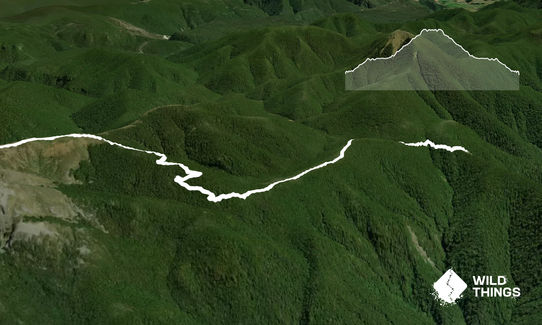
Beautiful alpine environment complete with birdsong and native bush. Great views once you get near the hut. Upon reaching the Mt Arthur Hut, continue past it for 5-10 minutes following the trail to the plateau above before turning around. These are the best views of the Tasman Bay and Kahurangi National Park.
Well maintained track, great signage. The track is mostly uphill on the way out, mostly downhill on the way back with a few flat areas. Toilets can be found at Flora Carpark and at the Mt Arthur Hut.
If you know of any public toilets near the trail start or on the route, please login and then let us know so we can update this section.
Parking at Flora Carpark. Own vehicle (4 wheel drive recommended) required.
31 km
43 minutes
No
No
Easy.
Follow the signs to Mt Arthur Hut on the way out, and to Flora CarPark on the way back.
Generally good.
Seam-sealed waterproof jacket, Windproof jacket, Gloves, Beanie/thermal headwear, First aid kit, Extra food for emergencies, Cellphone
Water should be available at Mt Arthur Hut but after a dry spell it shouldn't be relied upon.
Care needed in winter on both the access road and the trail as this is an alpine environment and the weather can close in suddenly. Check the foreceast and be prepared with appropriate clothing and food/water.
Trail Legend
Login as a VIP to become a Trail Legend. Learn about Trail Legends.
Fastest Known Times (FKTs)
You and Mt Arthur Hut
As a VIP member you can record private notes for this trail, see all of your times and more.
Already have an account? Login now
These overlap with this trail to some degree. You may wish to combine them but please note that to qualify for FKTs on these runs you should record a separate activity for each.
Send to your phone
Scan the below QR code to open this trail on your phone.

Tip: position the QR code in your phone camera screen.


