Last Updated: 21st Sep 2023

Intermediate - Experienced

Save Trail Save

I've done it Done

Canaan to Birds Clearing

Motueka, Tasman

Submitted by Stu Houston

Last Updated: 21st Sep 2023

Intermediate - Experienced

Save Trail Save

I've done it Done

Open

Grunt Factor: 28 ?

Gnarl Factor: 57 ?

14.0km

315m

400m

831m


Login as a VIP to see driving directions, distance and time.

Trail Map

Type of Run

Back country - remote

Point to Point (one way)

Undulating, some big hills

Native bush

Riverside

Run Makeup

20%
20%
60%

Farm Road / 4WD Track

Moderate Single Track

Technical Single Track

Average Uphill Gradient: +6.6%

Average Downhill Gradient: -6.5%

Trailhead

Login as a VIP to see the trailhead information.

Estimated Times to Run

3:00

Slow

2:15

Moderate

1:30

Fast

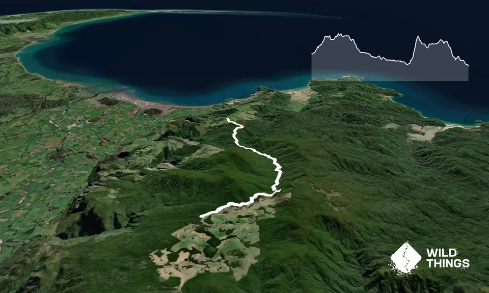
This is a point to point so is best if someone drops you off at Harwoods Hole Carpark then drives around and up to Birds Clearing to pick you up. Or to make it easier on the driver and to add 9 km of long downhill to the runner you could arrange to meet at Pohara Beach for a swim !! If you've never been to Harwoods Hole itself its worth the 6 km detour before you start as it is the deepest hole in the Southern Hemisphere and you could put the Empire State Building in it and still have 100 metres to fall to its roof !!!

Follow the well marked DOC mountain bike/walking track out of the carpark north on the Moa Park Track which gently climbs to Pages Saddle, where you turn left onto the Wanui Track. The track turns into a rough trail but is well marked and easy to follow.

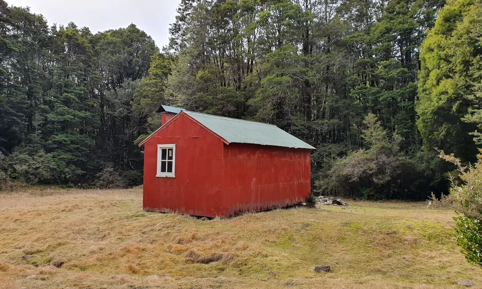
After 2 kms you come to the cute Wainui Hut beside the river. There is also a large aviary here used as part of Project Janzoon to house Kaka and Kakariki and various other species pre-release into the wild (check out details on Project Janzoon website for more info). From here skip or splash across the river to continue on down the valley and at the junction of Inland Track detour carry on down the Wainui track where you will again cross the Wainui River (this is the last place for water so fill up here).

The track now climbs up onto the Pikikiruna Range and follows it down till you break out onto the Birds Clearing with stunning views out over Golden Bay. There is a small grassy area with a small DOC kiosk - this is the official end of the track and from here out is a grass road at first, then a gravel road that drops 500 metres down to the village of Clifton. It pays for the driver to be really clear on where to go as the access to the track isn't easy to find with no signs on main road in Clifton, but its an adventure for both the driver and the runner. 

Sink holes, native bush and riverside. This is a fabulous little run with a bit of easy mixed with technical and river and bush scenery in a remote part of Abel Tasman National Park.

There is plenty of parking at the Harwoods Hole Carpark and it is a lovely Little DOC Campground.

33 km

57 minutes

Unknown

No

Moderate.

Take a good topo map of the area. It's reasonably straightforward track to follow but a map is essential.

Very patchy.

Lightweight fleece top, Short-sleeved thermal top, Windproof jacket, Personal Locator Beacon (PLB), Whistle, First aid kit, Extra food for emergencies, Survival bag, Cellphone, Map

Over the last 5 kms there is no water so fill up at last crossing of the Wainui River

Beware after heavy rain as the Wainui river can be too high to cross. It can get very cold on this trail any time of year as it is up at 800 metres at Birds Clearing and is very exposed. It can also get very hot !!

The track is very rooty and technical in places and can get very slippery after rain.

Wholemeal Cafe
Takaka
Golden Bay institution

You and Canaan to Birds Clearing

As a VIP member you can record private notes for this trail, see all of your times and more.

Register Now

Already have an account? Login now

Trail Reviews

Be the first to submit a review for Canaan to Birds Clearing!

Login to submit a review

Trail Running Community

Find people who are interested in or have completed this trail run.

You must register or login to view this feature.

Register Now

Overlapping Trails

These overlap with this trail to some degree. You may wish to combine them but please note that to qualify for FKTs on these runs you should record a separate activity for each.

Canaan Wainui Loop

Canaan Wainui Loop

Length: 30.2km

Level: Intermediate - Experienced

Other trails nearby
Kaiteriteri Loop

Kaiteriteri Loop

Length: 10.0km

Level: Beginner - Intermediate

Salisbury over Arthur

Salisbury over Arthur

Length: 28.0km

Level: Intermediate

Takaka Hill Walkway

Takaka Hill Walkway

Length: 5.8km

Level: Beginner - Intermediate

Kahurangi Caper

Kahurangi Caper

Length: 42.1km

Level: Intermediate

Find more trails and peaks nearby