Last Updated: 30th Dec 2024
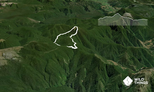
Lodestone Loop
Last Updated: 30th Dec 2024
Open
Grunt Factor: 18 ?
Gnarl Factor: 56 ?
7.0km
710m
710m


Last Updated: 30th Dec 2024
Last Updated: 30th Dec 2024
Open
Grunt Factor: 18 ?
Gnarl Factor: 56 ?
7.0km
710m
710m
Front country - easily accessible
Loop
Undulating, some big hills
Native bush
Open ridges/tops
Farm Road / 4WD Track
Moderate Single Track
Technical Single Track
Average Uphill Gradient: +20.3%
Average Downhill Gradient: -20.2%
VIP Feature: Send this route to your Garmin account so you can follow the course on your Garmin device.
Login as a VIP to see the trailhead information.
3:00
Slow
1:45
Moderate
1:15
Fast
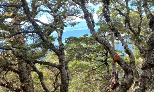
From the Flora carpark, go towards the four wheel drive track leading to Flora hut. Just by the gate you will notice a sign on the right pointing up towards a track saying Lodestone. Follow this track as it initially steeply climbs up through some rooty forest. It then flattens, goes across a wee ridge with a lookout point at the end.
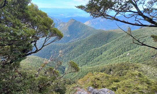
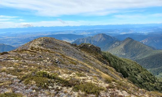
Then descend a little bit before beginning to ascend again. The ascent gets steep towards the end with views out over the steep drop to the right. Can be windy at times. After what feels like a solid effort you will arrive above the bushline and traverse the ridge to the highest point. Take a moment to enjoy the 360 degree views.
From here you can either go back the way you came or continue towards the Flora Hut. Follow the track markers down a steep rocky section to the bushline and continue down the hill following the orange markers on the trees. Eventually you will arrive at a little stream. Cross this and you will come out at Flora Hut. From Flora Hut turn left and follow the 4wd drive track along the river up to the saddle and then down to the carpark.
This trail includes the peak Lodestone.
In Flora carpark at the start of the track.
Parking at Flora Carpark. Can be very busy in the summer months.
35 km
45 minutes
No
No
Moderate.
Forest has some distance between markers occasionally but overall easy navigation.
Unknown.
Thermal leggings, Lightweight fleece top, Long-sleeved thermal top, Seam-sealed waterproof jacket, Windproof jacket, Gloves, Beanie/thermal headwear, Personal Locator Beacon (PLB), Whistle, First aid kit, Extra food for emergencies, Cellphone, Map
Only really from the hut or the stream just before the hut.
Can be exposed or windy on the top.
Trail Legend
Login as a VIP to become a Trail Legend. Learn about Trail Legends.
Fastest Known Times (FKTs)
You and Lodestone Loop
As a VIP member you can record private notes for this trail, see all of your times and more.
Already have an account? Login now
Thx Holly, really enjoyed it ..a great new addition to the wildthings database.
April 3, 2024
A fantastic short loop. Beautiful stunted beech forest draped in lichen on the way up, very steep near the top then 360 views. Steep again on the way down and slippery in places!
April 24, 2023
These overlap with this trail to some degree. You may wish to combine them but please note that to qualify for FKTs on these runs you should record a separate activity for each.
Send to your phone
Scan the below QR code to open this trail on your phone.

Tip: position the QR code in your phone camera screen.


