Tussocklands Traverse, Canterbury, New Zealand - Trail Running Directory - Wild Things

Last Updated: 31st Mar 2026

Intermediate

Save Trail Save

I've done it Done

Tussocklands Traverse

The less gnarly cousin of the Torlesse Traverse

Coach Stream Route, Trig M Route, Benmore Track, Thirteen Mile Bush track

Submitted by Jamie Bowley

Last Updated: 31st Mar 2026

Intermediate

Save Trail Save

I've done it Done

Open

Grunt Factor: 55 ?

Gnarl Factor: 55 ?

26.7km

1915m

2050m


Become a VIP to see driving directions, distance and time.

Trail Map

Type of Run

Front country - easily accessible

Point to Point (one way)

Very hilly

Native bush

Open farmlands

Open tussock/grasslands

Open ridges/tops

Run Makeup

20%
30%
40%
10%

Farm Road / 4WD Track

Easy Single Track

Technical Single Track

Untracked / Route only

Average Uphill Gradient: +13.90%

Average Downhill Gradient: -14.90%

Garmin Course

VIP Feature: Send this route to your Garmin account so you can follow the course on your Garmin device.

Send to Garmin

Learn about sending to Garmin.

Trailhead

Become a VIP Member to see the trailhead information.

Estimated Times to Run

Not suitable

Slow

6:00

Moderate

4:00

Fast

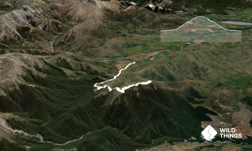
Drop a bike at the Benmore Track carpark, then head to the Coach Stream Route carpark at the bottom of Porters Pass. Follow a well-worn trail up the Coach Stream Route to junction with the Trig M Route, then head along the Trig M Route to the trig point. From there continue along the ridgeline to Rabbit Hill. Drop down into the obvious saddle and climb up through the trees up to the fenceline along the tops. Turn left and head along a worn trail to the antenna installation. From here turn right and take a steep scree descent to another saddle, climb the other side and make your way along to the top of Mount Benmore.

After a well deserved break, retrace your steps to the saddle and cut across the valley towards point 1444, and drop down the southeast spur to join up with the Benmore Track at the tree line - look out for rock cairns and orange flagging tape that mark the entry into the trees. Follow the marked track all the way to the carpark.

This trail includes the peaks Rabbit Hill (Acheron), Ben More and Trig M.

Longdrop at Benmore Hut.

Good parking at both carparks.

16 km

12 minutes

No

No

Moderate.

Best to go in fine weather as there are some untracked sections, though route is straightforward to follow when on the tops. From point 1444 take care to take the correct spur (south-east) down to the top of the Benmore Track.

Patchy.

Long-sleeved thermal top, Seam-sealed waterproof jacket, Gloves, Beanie/thermal headwear, Personal Locator Beacon (PLB), Whistle, First aid kit, Extra food for emergencies, Cellphone, Map

No water after climbing out of Coach Stream until you get to Benmore Hut. There is a water tank at the hut and many streams on the last section.

Easement access through Benmore Station to 13 Mile Bush (the end carpark) is closed June and July.

Sheffield Pies
Sheffield
https://www.sheffieldpies.co.nz
Great pies

Do you have another suggestion on where to go afterwards for the best coffee / cake / breakfast / brunch / beer?

You and Tussocklands Traverse

As a VIP member you can record private notes for this trail, see all of your times and more.

Become a Member

Already have an account? Login now

Trail Reviews

Be the first to submit a review for Tussocklands Traverse!

Login to submit a review

Trail Running Community

Find people who are interested in or have completed this trail run.

You must register or login to view this feature.

Register Now

Overlapping Trails

These overlap with this trail to some degree. You may wish to combine them but please note that to qualify for FKTs on these runs you should record a separate activity for each.

Korowai-Torlesse Roller Coaster

Korowai-Torlesse Roller Coaster

Length: 11.5km

Level: Beginner - Intermediate

Rabbiting around Benmore

Rabbiting around Benmore

Length: 32.0km

Level: Intermediate - Experienced

Benmore Hut to the bushline

Benmore Hut to the bushline

Length: 14.5km

Level: Intermediate

Roadworks on the A1

Roadworks on the A1

Length: 30.0km

Level: Intermediate - Experienced

Other trails nearby
Red Hill to Mt Lyndon Loop

Red Hill to Mt Lyndon Loop

Length: 16.6km

Level: Experienced

Kowai River Splash

Kowai River Splash

Length: 10.5km

Level: Intermediate - Experienced

Foggy and Castle Hill Peaks

Foggy and Castle Hill Peaks

Length: 11.4km

Level: Intermediate - Experienced

Annavale Track

Annavale Track

Length: 15.4km

Level: Beginner

Find more trails and peaks nearby

Wild Things
Wild Things
Explore more

Plan smarter, stay motivated, track your progress, and unlock the full Wild Things experience — while saving along the way.