Last Updated: 3rd Mar 2025
The High Dragon Traverse
Submitted by Mike McManaway
Last Updated: 3rd Mar 2025
Open
Grunt Factor: 140 ?
Gnarl Factor: 70 ?
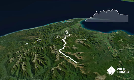
60.0km
4000m
3300m
1550m


Last Updated: 3rd Mar 2025
Submitted by Mike McManaway
Last Updated: 3rd Mar 2025
Open
Grunt Factor: 140 ?
Gnarl Factor: 70 ?
60.0km
4000m
3300m
1550m
Back country - remote
Point to Point (one way)
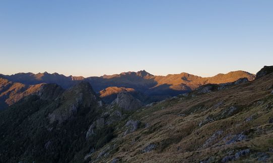
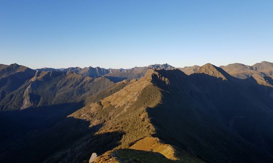
Mountainous
Native bush
Lakeside
Open tussock/grasslands
Open ridges/tops
Farm Road / 4WD Track
Easy Single Track
Moderate Single Track
Technical Single Track
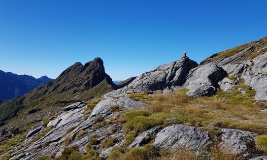
Untracked / Route only
Average Uphill Gradient: +11.9%
Average Downhill Gradient: -10.9%
VIP Feature: Send this route to your Garmin account so you can follow the course on your Garmin device.
Login as a VIP to see the trailhead information.
Not suitable
Slow
20:00
Moderate
16:00
Fast
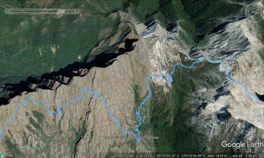
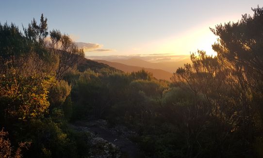
The Dragon’s Teeth high route is a famed traverse through the Kahurangi's Douglas Range normally done from north to south. Starting at the Cobb is possible but adds an intimidating descent down the wire. It's recommended to fast pack the route before attempting a day run.
A light pack will pay huge dividends especially through dragonland. On the other hand you'll need to carry plenty of water during typical hot dry Kahurangi summers.
James Rd to Boulder Lake Hut (4-6 hrs). Often runnable on a reasonably maintained track. No/poor water until the lake. Good reception at Brown Cow Saddle.
Boulder Lake Hut to Saddle South (2-3 hrs). Run/hikeable on a rough track mainly through tussock and scrub. No/poor water until Adelaide Tarn Hut. Marginal reception at The Needle's Eye.
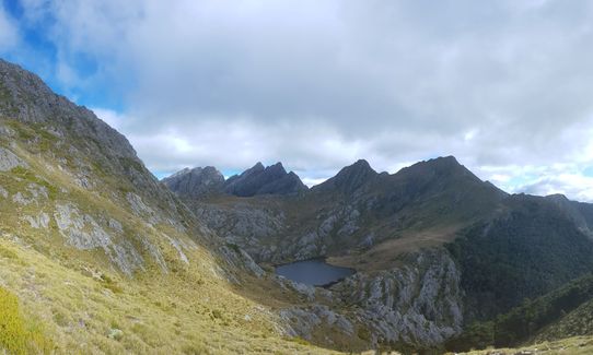
Saddle South to Anatoki Spur (2-4 hrs). Hike/climbable with tricky navigation & initimidating terrain. Good water at the Bra and tarn water at Anatoki Spur.
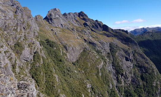
Anatoki Spur to Drunken Sailor (2-4 hrs). Run/hikeable following cairns through steep tussock country & numerous rocky tongues. Plenty of tarn water.
Drunken Sailor to Fenella Hut (3-5 hrs). Often runnable mostly along a ridgetop track. No water after Lonely Lake. Occasional reception.
Fenella Hut to Trilobite Car park (2-3 hrs). Very runnable with plenty of water.
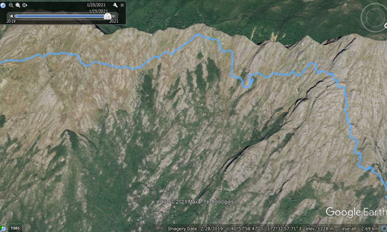
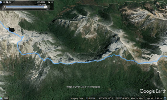
Start at the old DoC Car Park on James Rd (you'll need to phone the farmer). Follow the old farm track which joins the new DoC track after one hour or take the recently cut new DoC track which adds another hour. The track is easy to follow to Boulder Lake then dip left into the forest to avoid worst of the swamp then exit forest, filling up water bottles at the river. Hike up to Green saddle then follow a mostly well marked track to the iconic Adelaide Tarn Hut. Saddle South is the left shoulder/col visible above the hut.
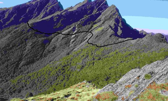
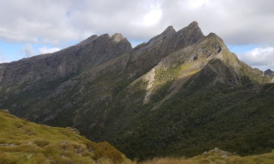
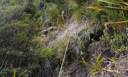
Saddle South to the Wire: Descend through the Slot then a high right traverse mostly above the forest to a large cairn underneath Mt Douglas. Descend the scree slope then follow occasional cairns on the forested Douglas/Dragon ridge. Descend into Canyon Forest avoiding some false trails and don't miss a sharp right/upwards turn which leads out of the forest onto a small rock tongue. Up the tongue then traverse back into the forest and a minute later another sharp right/upwards turn leads to a delicate crossing of the fresh slip. Immediately past slip don't miss yet another sharp right/upwards tree climb onto an exposed traverse from where the wire can normally be sighted shining in the sun. Drop down into Magic Forest following cairns to base of a cliff then zigzag up some delicate exposed ledges staying first to the right of the wire then traversing underneath it. Pull yourself up the well anchored 25m wire and onto the spur.
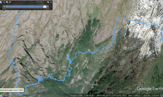
Wire to Anatoki Spur: Zigzag down the delicate slab to the tarns below then traverse the tussock lands taking care not to descend too soon. Stay high and traverse onto the bigger Locomotive tongue at a gap in the bluff, only then following a line of cairns downhill and eventually diagonalling rightwards through a wet spaniard gulley to a steep creek and the Bra hanging from a tree on edge of the forest. Enter the forest 20m below the bra then don't miss turn upwards via a well flagged tree. This is gnarly overgrown shrub country on steep terrain but at least track is easy to follow with orange markers. Traverse under the cliff face then a sharp turn right leads eventually down to the Bathtub (last good water). Ascend an old scree slope then cairned turn left back into bush. Then numerous zigzags up the face following little ledges but well signed with orange markers onto the Anatoki Spur.
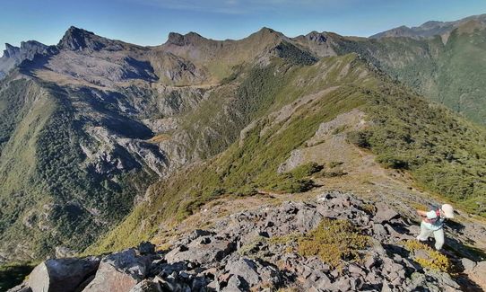
From Anatoki Spur: Ascend the spur for 10-15min passing various tarns and a campsite until you intersect with the high cairn marked trail. Anatoki land has numerous elevation gains and losses as you navigate the tongues and canyons. Don't lose lose sight of the next cairn and if in doubt stay high. Keeping an eye on the GPX tracklog helps. From Drunken Sailor descend to Lonely Lake and fill up water just before the hut. Follow the track up through forest onto the main more open ridge and continue south on a mostly well marked track but with no/poor water. Fenella Hut is equipped with gas and often quite busy so perhaps sweet talk an evening brewup before the final jog out to Trilobite which will feel painfully long but can be done on auto pilot. Congratulations.
Climbing the Wire: The original so called "wire" was removed by DoC in 1993, but has been replaced recently - though not by DoC. Spotting it from a distance makes navigation easier and with upper body strength it's an easy way up the steep scrubby rock. For parties without rock climbing experience it can feel intimidating and trampers with heavy packs might need to carry a short rope. There was a serious accident & evacuation here a few years ago (google stuff.co.nz).
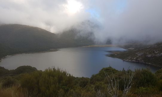
Huts: The huts are not bookable but Boulder Lake is spacious and rarely full (8+ beds). Adelaide Tarn Hut (3-4 marginal beds only) is the risky one- do not rely on sleeping inside if arriving late in the day. Lonely Lake (4 good beds) is a friendly spot but if full you'll be sleeping outside or keep going to Fenella Hut (12+ beds and serviced).
This trail includes the peaks Black Cow and Mt Douglas.
If you know of any public toilets near the trail start or on the route, please login and then let us know so we can update this section.
Contact local runners Mike McManaway and Britta Steude who may be interested in a key swap.
22 km
24 minutes
No
Yes
Name: Brendon Robinson
Telephone: 027 524 8264
Extreme.
Very patchy.
Waterproof leggings, Thermal leggings, Lightweight fleece top, Long-sleeved thermal top, Seam-sealed waterproof jacket, Gloves, Beanie/thermal headwear, Personal Locator Beacon (PLB), Whistle, First aid kit, Extra food for emergencies, Survival bag, Cellphone, Compass, Map, Headtorch and spare batteries, Gaiters
see notes, carry heaps
only recommended in good weather
see "the wire" in notes
Trail Legend
Login as a VIP to become a Trail Legend. Learn about Trail Legends.
Fastest Known Times (FKTs)
You and The High Dragon Traverse
As a VIP member you can record private notes for this trail, see all of your times and more.
Already have an account? Login now
Amazing route! i've only tramped it. But adding this comment to note that the wire was removed again by DOC in May 2024. We did not find where the wire used to be so we followed the cairned route that decends a bit further before climbing steeply up onto that spur. Can confirm the bra is still there though!
January 8
WH
An incredible route -- world-class adventure. Only for those with significant back-country experience, and only to be undertaken as a single-day mission in perfect weather and as part of a group. Don't cut any corners with this one -- it has multiple hazards and is very exposed for long periods. But with good preparation it presents a worthy challenge that you'll remember the rest of your life. Thanks so much to Mike McManaway for all his work putting it together, and for guiding Nancy Jiang and I on a perfect day.
January 7, 2024
Stunning trip. Advisable to do this initially as a tramp or alternatively with someone very familiar with the route (as I did with Mike M). There are various points where getting the route wrong will result in serious risk. Even the marked route has serious exposure and should be undertaken by those experienced in the backcountry and a head for heights.
For those who do brave it, you are in for an absolute treat.
April 10, 2022
This was an epic and beautiful day in the mountains. Im very grateful to Mike and Britta for guiding me. I recommend caution for people considering running this and a single day on your first attempt. There are many places where GPS will not be enough due to deep gullies and rock climbing. The route is mostly cairned but there are places where you can easily lose an hour.
Good luck, it's worth your effort.
November 14, 2021
These overlap with this trail to some degree. You may wish to combine them but please note that to qualify for FKTs on these runs you should record a separate activity for each.
Send to your phone
Scan the below QR code to open this trail on your phone.

Tip: position the QR code in your phone camera screen.


