Lake Hauroko and The HumpIntermediate - Experienced
Submitted by Kate Annan
Back country - remote
Point to Point (one way)
Very hilly
Native bushBeachLakesideOpen ridges/tops
Intermediate - Experienced
Not Suitable (Slow)
11:00 (Moderate)
8:00 (Fast)
-11.0%
+10.4%
Fastest Known Times (FKTs)
Please set your gender to see your position on the FKT leaderboards.
Men
There are currently no male FKTs for Lake Hauroko and The Hump.
Women
There are currently no female FKTs for Lake Hauroko and The Hump.
Filter FKTs
The more , the harder the FKT will be to beat. Learn about Fastest Known Times.
Description
For most mortals this one is going to involve quite a lot of walking, but it's an amazing route that's achievable as a day trip for Wild Things who don't mind a bit of grunt up and down steep hills and through bush. You could also split this into two days with a stay at Teal Bay Hut.
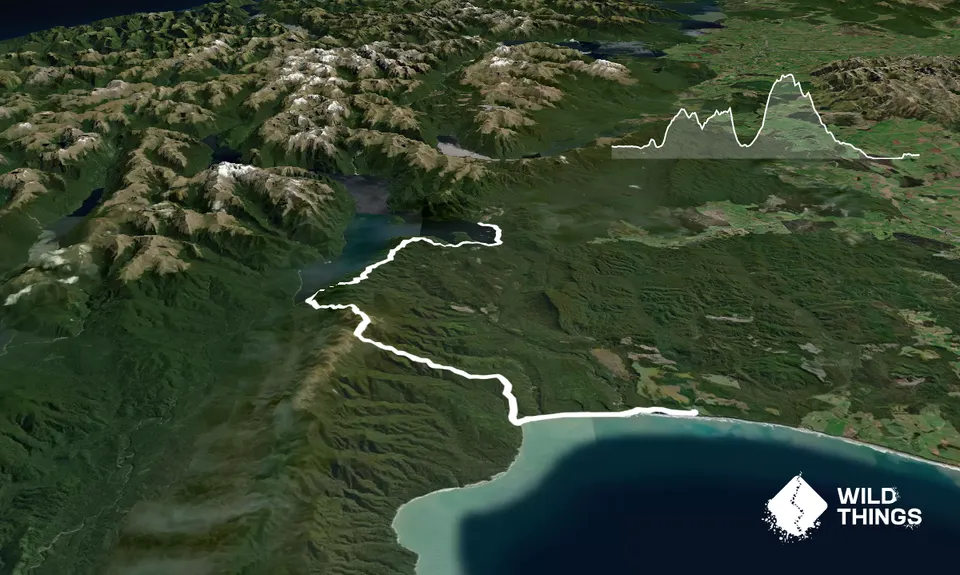
Beginning at Lake Hauroko follow the trail briefly through the bush then along the lakeside, watch out for the giant orange marker indicating the point for heading back into the bush. Follow the trail and orange triangles onto the ridge and along. There are a few that have blown down or become a bit overgrown but no real navigational issues likely as long as you're paying attention. Mostly you're tucked down below the trees but watch out for the viewpoints, they are breathtaking.
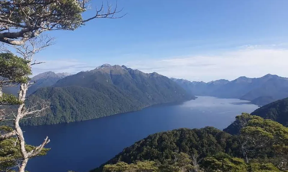
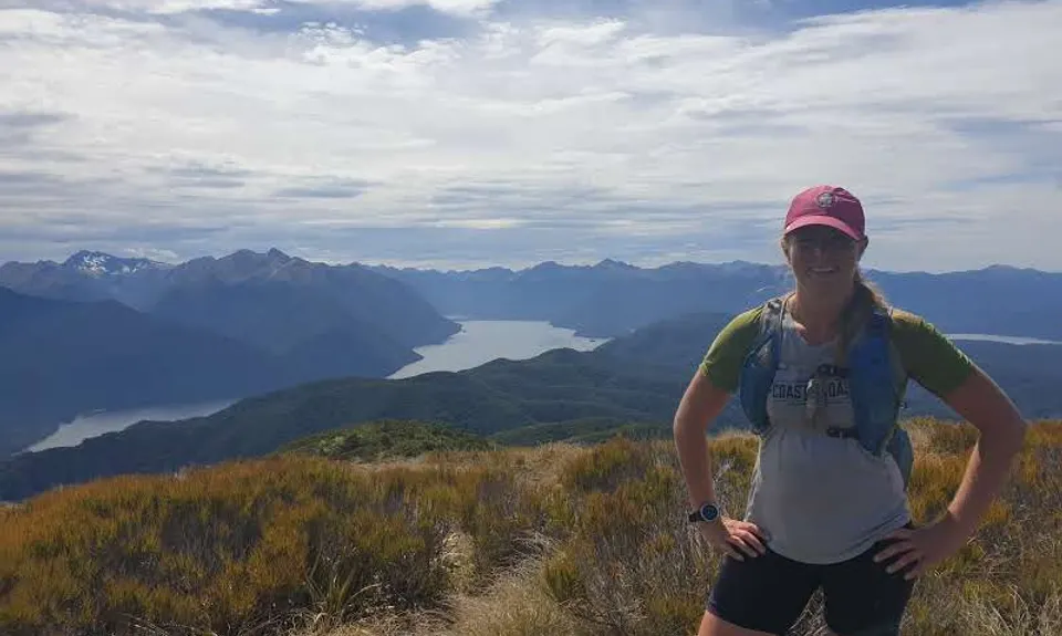
It's a steep descent to Teal Bay Hut then almost as steep (but about twice as much vertical distance) back up to get up to The Hump, but the views from up there are worth it! There are a few k's along the tops then you're standing on the high point of the Hump Ridge with views back over Lake Hauroko into Fiordland and south to the sea and Stewart Island; you can also look along the coast to the finish point, maybe thinking it's still a very long way away depending how your day is going.
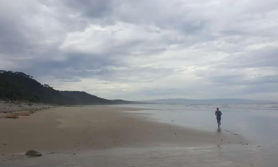
About a km after The Hump itself (with a little ascent again) there will be another orange marker to your left leading to the trail back down. A fun descent takes you to a 4WD track, follow the main track ignoring tracks to either side until you join the South Coast Track. Turn left and briefly follow the gravel road then down onto the beach until the bridge over the Waikoau. Fun fast single track takes you to Rarakau car park (via one last kicker with a whole heap of steps).
Trail Community
Features of interest
Views into Fiordland and out to sea.
Make Up of Run
Untracked / Route only: 10%
Technical Single Track: 50%
Moderate Single Track: 20%
Easy Single Track: 10%
Farm Road / 4WD Track: 10%
Route Data
Reviews:
Photos:
Your Trail Wishlist
All the runs that are on your To Do list (no limit).
Add to wishlist view wishlistWild Explorers
I did it!-
Access
Start from the carpark at the end of Lillburn Valley Road, any further would take you down the slipway into the Lake so you can't miss it.
Finishes at Rarakau, which is the carpark for the Hump Ridge and South Coast Tracks.Car park at each end, both quite busy sites. No public transport but there are local operators that offer shuttle services. It's 60km between the carparks so 3-4 hours on a bike or about 1.5hrs drive. There's a DOC campsite a few km before the start on Lillburn Valley Road.
45 km
71 minutes
No
No
-
Staying Safe
Moderate.
Watch out for orange marker triangles, you can usually see the next one from each so if you can't then backtrack. A few places where they've blown down or are overgrown but no real issues as long as you're paying attention. The ridge is sparsely poled; in good weather you can see all along, in bad weather navigation skills would be required.
Non-existent.
Thermal leggings, Long-sleeved thermal top, Seam-sealed waterproof jacket, Windproof jacket, Gloves, Beanie/thermal headwear, Personal Locator Beacon (PLB), Whistle, First aid kit, Extra food for emergencies, Survival bag, Cellphone, Compass, Map, Headtorch and spare batteries.
After leaving the lake (which people may not want to drink from anyway) there is none until the end of the descent to Teal Bay Hut and some river crossings just after the hut. After that none until the finish.
Prone to muddiness, especially east of the ridge. The tops are very exposed to wind and rapidly changing weather so come prepared.
-
Sponsor this trail