Last Updated: 21st Sep 2023

Intermediate

Save Trail Save

I've done it Done

Herbert Dabs

Oamaru, Otago

Submitted by Joe Benbow

Last Updated: 21st Sep 2023

Intermediate

Save Trail Save

I've done it Done

Open

Grunt Factor: 19 ?

Gnarl Factor: 37 ?

11.6km

650m

650m

350m


Login as a VIP to see driving directions, distance and time.

Trail Map

Type of Run

Front country - easily accessible

Loop

Undulating, some big hills

Dog Friendly

Native bush

Run Makeup

30%
20%
30%
20%

Gravel Road

Easy Single Track

Moderate Single Track

Technical Single Track

Average Uphill Gradient: +9.7%

Average Downhill Gradient: -9.9%

Trailhead

Login as a VIP to see the trailhead information.

Estimated Times to Run

2:30

Slow

2:00

Moderate

1:15

Fast

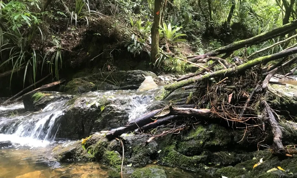
NB flooding (Jan 2020) has caused some treefall. Pay close attention for orange markers when crossing creeks if you have to divert

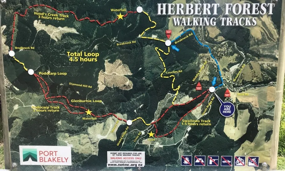
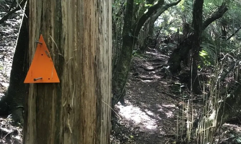
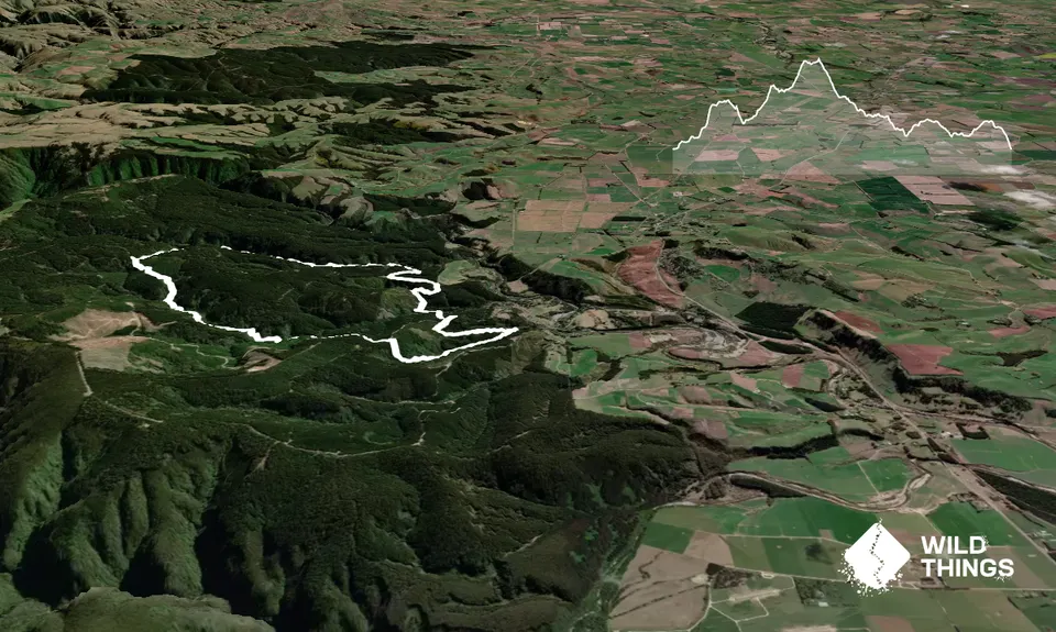
Starting at the Swallows Car Park, have a look at the track map - you'll be doing the full circuit (Total Loop 4.5 hours, though that's walking time0. There are 3 distinct sections of the trail, joined up with forestry tracks. It is fairly well signposted with orange arrows most of the way, but there are one or two places it is easy to miss the track so if you haven't seen an orange marker for a while, always backtrack until you do,

To start, head up the left track into the bush (Swallows Track) and follow this for about 1.5k, gradually at first then steeply up to arrive at a cave. Continuing past the cave, you'll come to the 4WD track, where you turn left signposted Podocarp Track. After a further 0.5k or so, you'll see a white sign for Podocarp taking you off down to the right.

The next couple of km take you through some absolutely breathtaking bush, with ancient moss-covered trees, plentiful birdlife, creek crossings, waterfalls. Savour it and remind yourself why you don't run on pavement! When you hit the intersection for Glenburnie Loop, TURN LEFT.

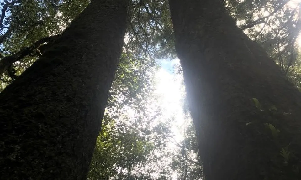
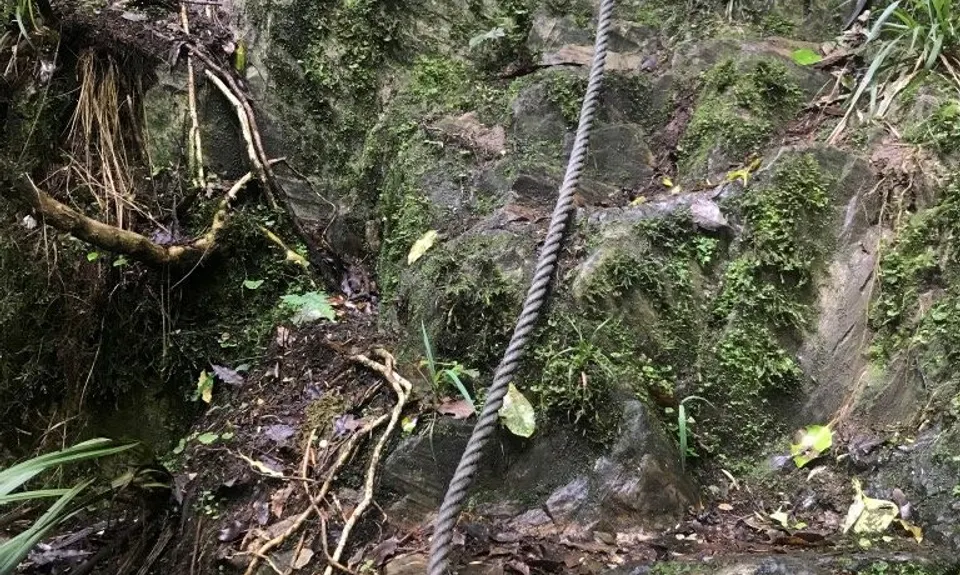
The tracks rejoin again a bit later at a glade with 2 huge trees. Follow the sign for Hoods Creek track (through the trees), then you'll soon come to a steep downhill section where a rope has kindly been provided to help you down. At the next junction, the trail splits and you can go either way to finish the Podocarp loop - go right to follow this route.

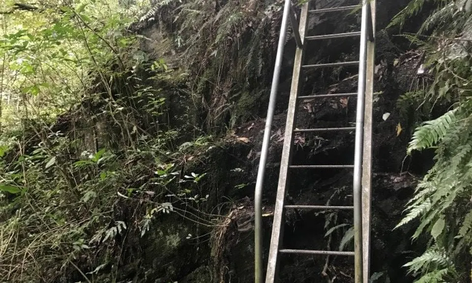
You'll soon come out onto the next forestry track, where you turn left and head uphill. Now comes the bit that's easy to miss. As you cross a junction of foresty roads, look out for a track map and orange arrow on the right. The Hoods Creek track begins behind the map heading down into the bush. Don't continue up the forestry road. Hoods Creek Track also has lots of creek crossings (take care to look out for the orange markers when you cross them) and at the end of this one you get a nice surprise in a 5m steel ladder you get to descend next to a waterfall!

The track then spits you out on the forestry road, where you turn right and have a 3k run back to the car park. It's fairly well signposted - you head uphill, turn left at the next intersection (onto Breakneck Rd) then downhill, turning right at the locked gate (now on Couches Rd) which winds down and back up, before another right turn signposted Swallows Car Park. Ignore the sign for Swallows Track you'll come to heading up to the right (that would take you back to the cave) but instead carry straight on downhill to lead you back to the car park.

Herbert Forest is one of the last native podocarp forests of north-east Otago. It was saved from destruction in the 1960s when 15km of walking tracks were built leading through ancient podocarp stands of rimu, kahikatea, matai, miro and totara trees.

Should be sufficient parking but keep valuables out of sight as it is quite remote and quiet at times.

27 km

23 minutes

Yes

No

Moderate.

As long as you follow the orange arrows and yellow track markers you'll be fine. Just watch out for the entrance to Hoods Creek track behind the map off the 4WD track as mentioned in the description.

Very patchy.

Long-sleeved thermal top, Seam-sealed waterproof jacket, Beanie/thermal headwear, Personal Locator Beacon (PLB), Whistle, First aid kit, Extra food for emergencies, Survival bag, Cellphone, Map.

Plenty of creeks along the route so water should be plentiful unless there has been drought conditions

Slippery rocks and lots of mud after rain. This is a track to saviour not rush, so take your time and soak it up!

Trail Legend

Steve Stewart

Steve Stewart

has completed Herbert Dabs once in the last year.

Learn about Trail Legends.

You and Herbert Dabs

As a VIP member you can record private notes for this trail, see all of your times and more.

Register Now

Already have an account? Login now

Trail Reviews

Awesome run through mixture of native and pine forest. Mostly single trail and then opens up to 4wd trail towards the end. Lots of little stream crossings along the way.
If you have a dog be aware that you’ll need to carry them down a ladder around 3 - 4m high. I have a boarder collie and he was all good carrying him down under my arm.
Would definitely do again.

Darren Robinson

April 23, 2022

Login to submit a review

Trail Running Community

Find people who are interested in or have completed this trail run.

You must register or login to view this feature.

Register Now

Other trails nearby
Caped Crusader

Caped Crusader

Length: 3.1km

Level: Beginner

Call me Herbert

Call me Herbert

Length: 6.9km

Level: Beginner

The Elephant

The Elephant

Length: 40.0km

Level: Beginner - Intermediate

Glen Eden Reserve Loop

Glen Eden Reserve Loop

Length: 4.3km

Level: Beginner

Find more trails and peaks nearby