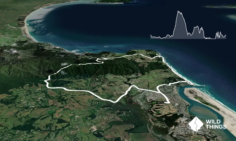
Run can be started anywhere along the mapped route. This detailed description starts from the corner of Cullen Street and Mangawhai Heads Road. Run Mangawhai Heads Road towards Cove Road. Turn left and run along the road until you meet King Road. Turn right on to King Road. Run for about 4K. The road bends to the left but you will see signs for Tanekaha Forest on the right. Turn off King Road (it is possible to park about 100m from the turn off from King Road; you will see a small bay on your right and a signpost for Tanekaha track). If you run one way the run is about 18Km from here back to Mangawhai.
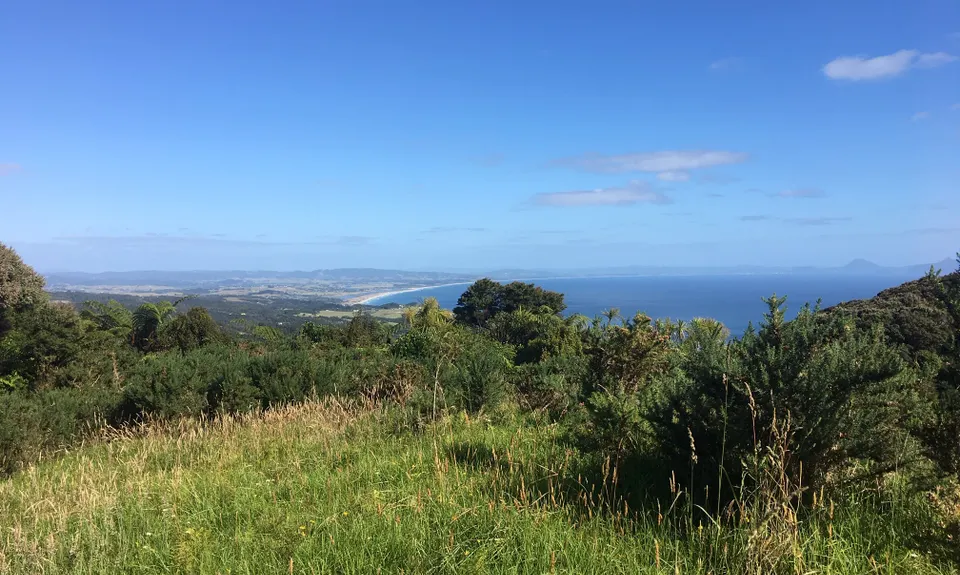
From the sign post continue north along the unsealed track for about 200m. At the bottom of a small descent you will see a stile on the right. Climb over this stile. Follow the track until you reach a swing bridge (and usually some disinfectant to treat your shoes). Cross the swing bridge and you will see a sign for the Tanekaha trails. Take the very first right turn down to a small river. Cross the river and follow the banks of the river for about 50m. The track then moves away from the river and into bush. The track continues up a ridge to the Brynderwyn crest and trig point (in the bush for about 1.25K). About half way up you will see a seat where you can have a rest and enjoy the view back to Mangawhai and the sea. You will know when you have reached the top as you will see the Trig Point where you can enjoy a spectacular view.
After you have taken in the view, return to the track and turn right (onto the Old Brynderwyn track). The track descends down some shallow clay steps for about 70m. You then take a sharp right hand turn which turns you back up hill onto the Langsview Track (heading East South East). After about 400m you will see a small opening on your right (you can stop for another vista view). Continue along the track, you will go past a house (on your left) as you go up a short grassy rise. Not long after this you will descend onto a dirt track (suitable for vehicles). You continue along this track (which is mostly downhill) for about 1.5km until you hit a sealed road. Descend down this road (Tarata Place) for about 300m until you see a track to your right (if you start to climb up again you have gone too far!). Follow this track until you reach a car park on Cove Road.
From here turn left and run on the side of the road (downhill) until you reach a turn off (right). This is the no-exit Bream Tail Road (like a private driveway) it climbs uphill through farmland offering spectacular views of the coast. Please leave farm gates as you find them. Use stiles where provided. After 1.8 km, you leave the road to your right over a stile and follow markers across pasture to reach another tarmac driveway (part of a subdivision). Turn right for a few metres then it’s back into pasture (through a gate) and down a SE spur, across a marshy area at the bottom (through 2 gates), then straight up by the bushline and over a steep hill.
Follow the well-benched track that then zigs NE down into a bush gully (kauris galore) then zags up the other side to come out at another section of tarmac driveway. Just over the bank on the other side of it is the Mangawhai Walkway. Turn left (North) and follow the track along the cliffs and down to the rocky beach where you will see a hole in the rock to your right. At low tide you can rock hop south along for about 1.5Km until you hit the sandy beach run south along the beach to Managwhai Heads (at high tide you will have to run back up the steps until you meet the point at which you first joined the Managwhai Walkway. From here continue south and follow the track along the cliffs and down to the beach.
Continue along the beach until the carpark at Mangawhai Heads). On the right of the car park you will see a track (look for a small sign to the left of the white rock). Climb the short steep hill to the glorious view of Cape Rodney to the Poor Knights. At the top, turn left as the track leads west down the hill to a private subdivision You should see either orange markers or small silver s and black signs of trampers to keep you on the right track. Cross the road to climb the second steep hill. Take in the next spectacular view looking south. Continue down the hill to Pearl Street. Cross the road to climb the third hill. Note there is a short section of the track on a sub divisional road. Re-enter the track on the left and climb the last rise to Cullen Street. Continue down the road heading to Mangawhai Heads where you can enjoy a well earned refreshment!