Last Updated: 21st Sep 2023

Beginner

Save Trail Save

I've done it Done

Goldschmidt Panoramic Trail

Mangawhai, Northland

Submitted by Mike Tennent

Last Updated: 21st Sep 2023

Beginner

Save Trail Save

I've done it Done

Open

Grunt Factor: 9 ?

Gnarl Factor: 55 ?

3.4km

330m

330m

67m


Login as a VIP to see driving directions, distance and time.

Trail Map

Type of Run

Urban fringe

Out and Back

Very hilly

Native bush

Plantation/exotic forest

Coastal

Open ridges/tops

Run Makeup

5%
10%
65%
20%

Sealed Road

Easy Single Track

Moderate Single Track

Technical Single Track

Average Uphill Gradient: +16.4%

Average Downhill Gradient: -16.4%

Trailhead

Login as a VIP to see the trailhead information.

Estimated Times to Run

1:00

Slow

0:45

Moderate

0:30

Fast

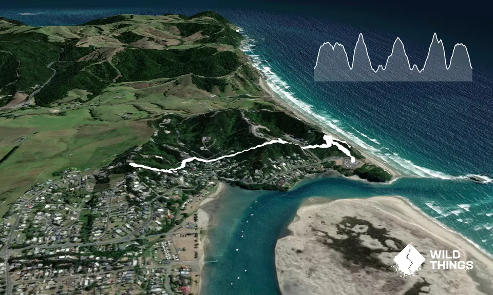
The climb starts straight away with quite a few steps thrown it. After barely 200m and having already climbed over 50m you come to an intersection, the sign for the trail points left, but take a right here and climb the trail to the top for some epic views.

Once you've taken that in and snapped a few good shots, head back down to that intersection and this time carry on. The trail now winds its way down to a street. Look over the street and slightly right and you will see the next entry, then start climbing again to the highest point of the trail (just) and some more great views. About halfway up this climb there is an intersection where the trail appears to head straight ahead but there are steps up to the left... take the steps.

After hitting the high spot you will again head down to another street, this time right next to a set of security gates. Cross the road in front of the gates and carry on, you will climb for a bit and come out onto a sealed driveway, turn left and head slightly down the drive and you will see the next entry. This is the last climb. Head up until you come to the end of a cul-de-sac with a chain across. Then turn around and head back the way you came, minus the first extra climb to the lookout.

Some of the best views you will get over Mangawhai Heads, the river and coast and the coastal islands.

Plenty of parking

7 km

9 minutes

Unknown

No

Moderate.

Take note on the way up where you exited from trails so that you don't miss them on the way back.

Generally good.

Windproof jacket, Whistle, First aid kit, Extra food for emergencies, Cellphone, Map

No water although you are frequently close to houses so I guess you could ask.

At places it looked like it could be very slippery and treacherous if it got wet enough to be muddy... which up here would be seldom.

Steep steps up and down

MEAN BRGR
6 Wood Street, Mangawhai Heads
https://www.facebook.com/MEANBRGR/
Not a massive burger fan but these guys do a very nice burger!

You and Goldschmidt Panoramic Trail

As a VIP member you can record private notes for this trail, see all of your times and more.

Register Now

Already have an account? Login now

Trail Reviews

Hilly and can be very slippery after rain. A great add on to get you to the beach from within the Heads to do the cliff path, if you start at the opposite end (end of Cullen Street).

Maggie Davies

January 22, 2020

Login to submit a review

Trail Running Community

Find people who are interested in or have completed this trail run.

You must register or login to view this feature.

Register Now

Overlapping Trails

These overlap with this trail to some degree. You may wish to combine them but please note that to qualify for FKTs on these runs you should record a separate activity for each.

Mangawhai Heads Snarler

Mangawhai Heads Snarler

Length: 25.0km

Level: Beginner - Intermediate

Mangawhai Adventure Day

Mangawhai Adventure Day

Length: 40.0km

Level: Intermediate

Other trails nearby
Langs View Track

Langs View Track

Length: 12.7km

Level: Beginner - Intermediate

Tanekaha Trails

Tanekaha Trails

Length: 8.0km

Level: Beginner - Intermediate

Find more trails and peaks nearby