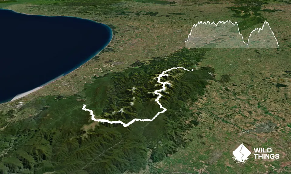
Logan, Mt Dundas (debated), Arete, Bannister, Point 1513, Lancaster, Girdlestone, Brockett, Mitre, Peggys Peak, North King, Middle King, South King, McGregor, Angle Knob. It’s quite a mouthful really. Look at a map and these 1500 metre giants are dotted at fairly even intervals down the craggy eastern side of the Tararua Mountain Range.
Then look again…
Look again and you might just spot Mt Hector, the outlier. All the way across the range on the Western side.
Pukemoumou it’s Maori name, means “Hill of Desolation”. A fitting name and possibly a bit of a warning for anyone thinking of tackling it as a route. Don’t take this lightly.
The challenge is simple in its brief. Enter at any road end you see fit, summit all the 1500 m+ peaks in the Tararua Range and exit at the road end of your choosing. Simple. Right? Putara lends itself as the obvious start point, providing quick access to the tops and the opportunity to bag the 14 eastern peaks in daylight. But on reaching Angle Knob there are some big decisions to be made. First to beckon is the Southern Main Range, a massive drop down off Mt Holdsworth via Isabelle to Mid Waiohine Hut. Followed by a not insignificant 1,000 meter scramble up to the mighty Aokaparangi. From here the SMR sawtooths relentlessly to the big climb up to Bridge Peak, on past Kime Hut to finally bag Hector and then back down to Otaki Forks. Second option is to follow in the legendary Colin Rolfe’s footsteps via Bull Mound and the Dress Circle. And finally the seldom traveled wild Neil-Winchcombe Ridge via Totara Flats and Cone.
All of these routes have their attractions and their shortcomings which any would-be assailant must weigh up.
Tararua 1500's in order of height(m):
Mitre 1,571
Girdlestone 1,546
Peggy’s Peak 1,545
McGregor 1,540
Brockett 1,538
Bannister 1,537
North King 1,535
South King 1,531
Hector 1,529
Mid King 1,521
Point 1,513
Angle Knob 1,510
Arete 1,505
Lancaster 1,504
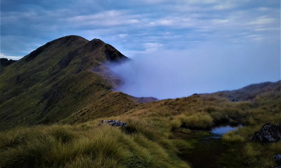
The Tararuas should really be called the Northern Alps. They may have a notorious reputation but on a fine day are stunning in their rugged beauty. From the sub-alpine Goblin Forests to the craggy tops, they are ever changing. From the Stan Evans memorial cross on Herepai at one end of the range to Field Hut, the oldest hut in the Tararuas, there are many features steeped in history. On the approach to Lancaster the majestic Park Valley can be seen in all its glory, the only glacier-formed feature in the range. Tallest of the 1500's at 1571m, Mitre Peak provides some fun rock scrambling on the North-western approach to the summit. And finally the Hector Cross marking the penultimate 1500m peak on the route, which was erected by Wellington tramping clubs as a memorial to trampers killed in the Second World War. It's a nice place to reflect, when the weather allows... For a detailed history Chris MacLeans "Tararua: The Story of a Mountain Range" makes a great read if you can get your hands on it.
If you know of any public toilets near the trail start or on the route, please login and then let us know so we can update this section.
This route starts and ends on opposite sides and opposite ends of a mountain range. Get a good mate to drop you off and scrape you up at the end.
19 km
24 minutes
Unknown
No
Extreme.
This route is largely untracked and as such anyone undertaking it should be comfortable in their own abilities to identify and negotiate the many navigational challenges thrown up by it. It is strongly recommended that you reccie all sections of the route before taking it on in one go.
Herepai Hut (tank), tarn north of Logan, Arete Biv (tank), Tarn Ridge Hut (tank), tarn on the northern approach to North King, tarn just south of Mid King summit, Various tarns between Angle Knob and Jumbo (best used as backups, not on direct route), Powell Hut (tank), Mountain House Shelter (tank), Totara Flats Hut (tank), Large tarn just north of Cone Peak, tarn on eastern approach to Mt Hector, Kime Hut (tank), Field Hut (tank). Tank water is generally thought to be safe without treatment, tarn water is sitting and therefore should be treated with Aquatabs or similar before drinking. Be prepared to scoop up some wriggly things... There are some sections where water sources are few and far between, the ability to carry 3L of water should do the trick for these.
Over long periods of little rain, water sources can become unreliable. Tarns and tanks can dry up, consider seeking local knowledge for current conditions if in doubt. This is a very exposed route, the majority of which is on open tops, a good weather window of 48hrs should therefore be considered a minimum. Due to the length/exposure of the route it lends itself to summer attempts to take advantage of longer daylight hours and warmer conditions.
The Tararuas have been gifted with a grand total of around 80 fine days a year. The rest? Well one look at the angle the trees grow at near the tops will give you an idea of what it's like for the rest of the year. Even if the weather is fine when you set out be prepared for storm conditions. Keep well clear of the tops if a southerly front is forecast. Clag (mist) is often present in the Tararuas and can make navigation difficult. This is rugged terrain, there are a number of sections requiring some clambers with exposure to large drops. These include: Section between Bannister and Pt. 1513, Section between Waiohine Pinnacles and Tarn Ridge, approach to Girdlestone, approach and retreat from Mitre, Descent off North King, Sidle around Broken Axe Pinnacles, Descent off Neill (watch for slip on west descent, track is north of this) Section from Winchcombe to Mt Hector. Spaniard Grass (AKA Bastard Grass) is stabby and will not be your friend.
This is a committed route, if things turn pear shaped any help will be a long time arriving. Carry sufficient gear to keep you alive should you be stopped on the tops by injury or weather. Bail out options involve long treks out, be familiar with these options as there is a very real chance that you will need them. Sleep monsters are real...
Your Support Person
Otaki Forks Road-end
After a beer and a feed (hot and savory please Mrs/Mr support person!) the only place you'll be wanting to go is home and bed.
Do you have another suggestion on where to go afterwards for the best coffee / cake / breakfast / brunch / beer?
These overlap with this trail to some degree. You may wish to combine them but please note that to qualify for FKTs on these runs you should record a separate activity for each.
We don't store or share your location; it's only used for these features. You can continue without it, just without distance sorting and live map features.
Send to your phone
Scan the below QR code to open this trail on your phone.
Tip: position the QR code in your phone camera screen.
.jpg)
.jpg)