Last Updated: 21st Sep 2023

Intermediate

Save Trail Save

I've done it Done

Rad Ruahine Ramble

Ashhurst, Manawatu - Wanganui

Submitted by Rosie Rochester

Last Updated: 21st Sep 2023

Intermediate

Save Trail Save

I've done it Done

Grunt Factor: 50 ?

Gnarl Factor: 32 ?

33.0km

1775m

1775m

1168m


Login as a VIP to see driving directions, distance and time.

Trail Map

Type of Run

Front country - easily accessible

Combo

Very hilly

Native bush

Riverside

Open farmlands

Open ridges/tops

Run Makeup

50%
20%
10%
20%

Farm Road / 4WD Track

Easy Single Track

Moderate Single Track

Technical Single Track

Average Uphill Gradient: +12.0%

Average Downhill Gradient: -11.4%

Trailhead

Login as a VIP to see the trailhead information.

Estimated Times to Run

8:00

Slow

6:30

Moderate

4:00

Fast

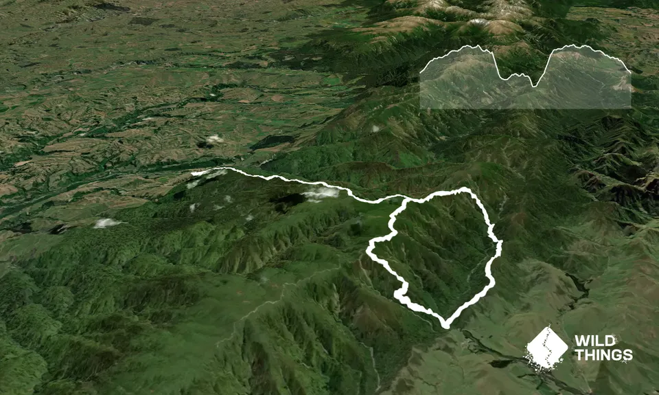
The run starts at the Ruahine Forest park DOC sign. If you start early morning you will be greeted by the most spectacular sunrise with views as far as the eyes can see, right across to Mt Taranaki, Mt Ruapehu and Ngarahoe. It's an 8km 4WD track uphill, through the forest with views most of the way up to kick it off.

At around 8.4km turn left at the Stanfield Hut DOC sign. It's an awesome run along the leatherwood tops then dropping all the way down to the hut, which gets quite muddy in places and typical Ruahine rooty technical stuff for a large chunk! It'll definitely slow you down and is not really runnable unless you have mean as skills!! Good fun!.

The track continues on behind the hut where you'll drop down to the stream. Follow the stream down for around 5-10 mins, 700 metres and look out for the large orange arrow in the bush on the LEFT of the stream - this is the Homes Ridge Track. The next 4km is an awesome undulating trail through bush & you'll pop out onto a grass farm track which then starts to head back down hill.

At around 16.5km keep an eye out down on your RIGHT for the large orange marker in the bush. It's around 500 metres down to the Tamaki West Rd carpark/campsite. There's a shelter here and its a nice spot for a snack. This is your halfway point. Follow the A Frame Hut DOC signed Track which zigzags its way all the way back up the the top of the ranges. Its a very well made trail, and as you gain elevation it again gets very rooty and more technical.

It's around 4km from the carpark up to A Frame Hut. Stunning views up here over the Hawkes Bay side of the island The hut which is renowned for being a dive, and vandalised, is in the process of being restored with some stunning artwork also being created, in the hopes of preserving it and getting some respect from users - we can only cross our fingers and hold our breath though looking it its history. It's around 3km along the 4WD road back to the Stanfield Hut sign that you turned off at earlier.

Carry on the 8km back down Takapari Road.

40 km

46 minutes

Unknown

No

Moderate.

Patchy.

Waterproof leggings, Thermal leggings, Lightweight fleece top, Short-sleeved thermal top, Long-sleeved thermal top, Seam-sealed waterproof jacket, Gloves, Beanie/thermal headwear, Personal Locator Beacon (PLB), First aid kit, Extra food for emergencies, Survival bag, Cellphone, Compass, Map, Headtorch and spare batteries

Stanfield Hut and stream

This is TOPS travel. Be prepared for horrific weather year round, it can change up there very quickly, can be unpredictable.
Have plenty of layers, hat, jacket etc......all the stuff!!
Expect snow in mid-winter

Visibilty can be NIL up here in a whiteout (very common)
When on the Takapari Rd section be alert for 4WD vehicles.
Many Hunters use this road as there entry/exit points into the forest park so you will likely see hunters with guns on the Takapari Road Side.

You and Rad Ruahine Ramble

As a VIP member you can record private notes for this trail, see all of your times and more.

Register Now

Already have an account? Login now

Trail Reviews

Be the first to submit a review for Rad Ruahine Ramble!

Login to submit a review

Trail Running Community

Find people who are interested in or have completed this trail run.

You must register or login to view this feature.

Register Now

Other trails nearby
Bushy Breathtaking Branch Rd

Bushy Breathtaking Branch Rd

Length: 12.0km

Level: Beginner - Intermediate

Manawatu Gorge Track

Manawatu Gorge Track

Length: 21.0km

Level: Beginner - Intermediate

Ruahine Double Crossing

Ruahine Double Crossing

Length: 20.8km

Level: Intermediate - Experienced

Iron Gate Hut to Tunupo High Point Loop

Iron Gate Hut to Tunupo High Point Loop

Length: 24.2km

Level: Intermediate - Experienced

Find more trails and peaks nearby