Last Updated: 14th Mar 2024

Experienced

Save Trail Save

I've done it Done

Mt Oxford Odyssey Ultramarathon

Mt Oxford Track, Wharfedale Track, Koromako Track, Link Track,

Coopers Creek, Canterbury

Submitted by Scenic Sports

Last Updated: 14th Mar 2024

Experienced

Save Trail Save

I've done it Done

Open

Grunt Factor: 83 ?

Gnarl Factor: 39 ?

50.7km

2225m

2210m


Login as a VIP to see driving directions, distance and time.

Trail Map

Event Aid Stations

Type of Run

Event

Back country - remote

Combo

Mountainous

Native bush

Open farmlands

Open tussock/grasslands

Open ridges/tops

Run Makeup

5%
40%
40%
10%
5%

Farm Road / 4WD Track

Easy Single Track

Moderate Single Track

Technical Single Track

Untracked / Route only

Average Uphill Gradient: +8.8%

Average Downhill Gradient: -8.7%

Trailhead

Login as a VIP to see the trailhead information.

Estimated Times to Run

Not suitable

Slow

7:00

Moderate

5:00

Fast

Mt Oxford Odyssey Ultramarathon

The 50km Mountain Ultra is a true adventure in the backcountry. The Ultramarathon has two mountains to climb as well as some great runnable single tracks. The Oxford Conservation Area is a true mountain environment, making this ultra a great challenge for those who are up for whatever the mountains bring.  This course has been designed to give competitors a challenge, but also with the aim of everyone finishing within the 12 hours available. 

Saturday 5th April 2025

VIP Reward: 10% off entry fee for any distance

Grab 10% off any of the distances for Mt Oxford Odyssey on Saturday 6th April 2024! There are 4 entry options to choose from (50km, 33km, 21km and 15km). Get amongst it!

Become a VIP Member to enjoy these rewards Login

About the Event Enter Now

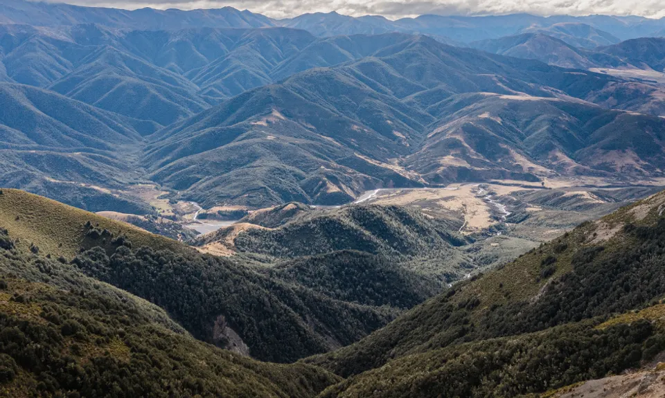
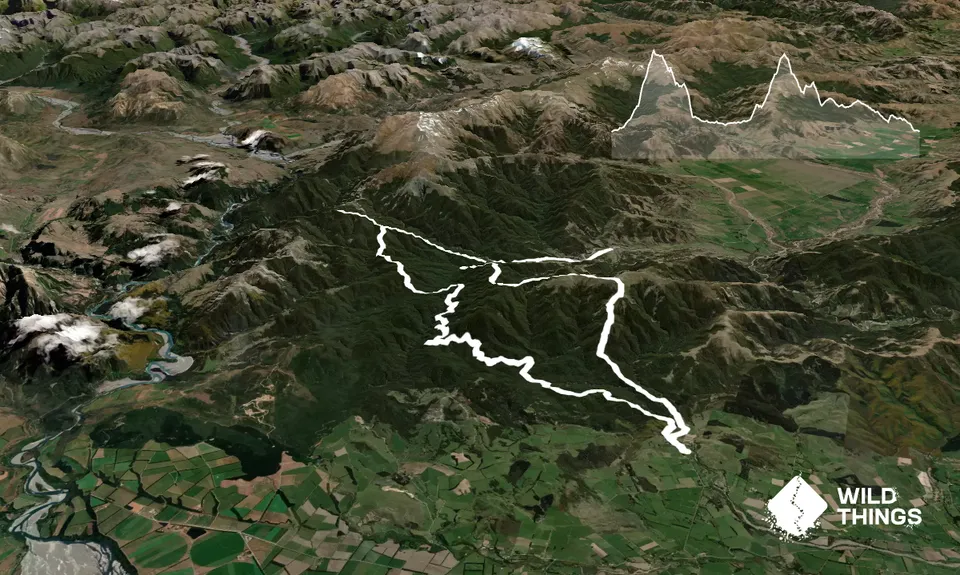
The 50km course starts with the ascent of Mt Oxford, starting from Coopers Creek carpark. Once you reach the summit you will then head across the top of the mountain enjoying 360 degree views of the Southern Alps, right across to the South Pacific Ocean.

You will then turn right and head down the mountain via Mt Oxford Route to the Wharfedale Hut. This is quite a technical section of the course. You turn right and head out towards the Townsend towards the Lees Valley. You will get some great running along here.

You cross the Townsend River once and continue until you reach it a second time. This is the turnaround point. You will then head back to the second mountain, Black Hill (when you reach the end of the 4wd track at the carpark area you will head off to your right (Black Hill).

You will head up this mountain crossing a river and enjoying some great single tracks on your way. You will come to a junction near the top - turn to your right and head up to the Black Hill Hut - keep going and pop up to the summit for a quick look. You then descend back down Black Hill to the Wharfedale Track via Fosters Ridge.

When you reach the Wharfedale Track you turn to your right and head back along the Wharfedale towards View Hill. You will go over the Wharfedale Saddle and then eventually arrive at a junction near the base of Mt Oxford - you turn down the Koromako Track towards Coopers Creek. You take this track back to Coopers Creek (you don't visit Ryde Falls).

Make sure you follow the signs at each junction along this part of the trail and ensure you always head to Coopers Creek (not View Hill).

There is a final junction along the Koromako Track where you must turn left towards Coopers Creek and not turn right - otherwise you will end up back on the Wharfedale.

Enjoy!

This trail includes the peaks Mount Oxford and Black Hill.

The views at the top of Mt Oxford and Black Hill are incredible - 360 of the Southern Alps and on Mt Oxford you can see over the Canterbury Plains and the South Pacific Ocean. The beech forest is stunning and both mountains give you some great trails to enjoy.

The carpark can get very busy so best to head out early to ensure a decent spot. There is a toilet at the carpark. There is no public transport available. Oxford is approx 5-10 minutes drive where there are cafes and public toilets. (Oxford is a small rural town so shops not always open on the weekend.)

3 km

5 minutes

Unknown

No

Moderate.

This course requires some preparation - check the maps after reading the course description to ensure you are taking the right way at each junction.

Non-existent.

Thermal leggings, Short-sleeved thermal top, Long-sleeved thermal top, Seam-sealed waterproof jacket, Windproof jacket, Gloves, Beanie/thermal headwear, Personal Locator Beacon (PLB), Whistle, First aid kit, Extra food for emergencies, Survival bag, Cellphone, Map, Headtorch and spare batteries

You can get water from beside the Wharfedale Hut, along the Townsend River as well. There is a small river on your way up Black Hill as well. No water easily accessible for the final half of the course.

This is a mountain route so weather dependent. Check the forecasts and only go when safe.

River crossings - do not cross the Townsend if not safe to do so.
Usual mountain trail hazards.

Trail Legend

Kane Aitken

Kane Aitken

has completed Mt Oxford Odyssey Ultramarathon once in the last year.

Learn about Trail Legends.

You and Mt Oxford Odyssey Ultramarathon

As a VIP member you can record private notes for this trail, see all of your times and more.

Register Now

Already have an account? Login now

Trail Reviews

Be the first to submit a review for Mt Oxford Odyssey Ultramarathon!

Login to submit a review

Trail Running Community

Find people who are interested in or have completed this trail run.

You must register or login to view this feature.

Register Now

Overlapping Trails

These overlap with this trail to some degree. You may wish to combine them but please note that to qualify for FKTs on these runs you should record a separate activity for each.

Coopers Creek - Ryde Falls loop

Coopers Creek - Ryde Falls loop

Length: 14.0km

Level: Beginner - Intermediate

Mt Oxford - Wharfedale Track

Mt Oxford - Wharfedale Track

Length: 35.0km

Level: Intermediate

Mt Oxford Half

Mt Oxford Half

Length: 20.5km

Level: Beginner - Intermediate

Oxford Odyssey Marathon Route

Oxford Odyssey Marathon Route

Length: 41.0km

Level: Intermediate - Experienced

Mount Oxford Summit Scramble

Mount Oxford Summit Scramble

Length: 14.0km

Level: Beginner - Intermediate

Blackhill Hut Buster

Blackhill Hut Buster

Length: 32.0km

Level: Beginner - Intermediate

Lee Valley Peak Pursuit: Black Hill Blitz

Lee Valley Peak Pursuit: Black Hill Blitz

Length: 30.2km

Level: Beginner - Intermediate

Coopers Creek - Ryde Falls loop

Coopers Creek - Ryde Falls loop

Length: 14.0km

Level: Beginner - Intermediate

Mt Oxford - Wharfedale Track

Mt Oxford - Wharfedale Track

Length: 35.0km

Level: Intermediate

Mt Oxford Half

Mt Oxford Half

Length: 20.5km

Level: Beginner - Intermediate

Oxford Odyssey Marathon Route

Oxford Odyssey Marathon Route

Length: 41.0km

Level: Intermediate - Experienced

Mount Oxford Summit Scramble

Mount Oxford Summit Scramble

Length: 14.0km

Level: Beginner - Intermediate

Blackhill Hut Buster

Blackhill Hut Buster

Length: 32.0km

Level: Beginner - Intermediate

Lee Valley Peak Pursuit: Black Hill Blitz

Lee Valley Peak Pursuit: Black Hill Blitz

Length: 30.2km

Level: Beginner - Intermediate

Other trails nearby
Mt Oxford Odyssey Half Marathon

Mt Oxford Odyssey Half Marathon

Length: 20.5km

Level: Beginner - Intermediate

Mt Oxford Odyssey 33km

Mt Oxford Odyssey 33km

Length: 32.9km

Level: Intermediate - Experienced

Mt Oxford Odyssey 15km Trail Race

Mt Oxford Odyssey 15km Trail Race

Length: 14.6km

Level: Beginner - Intermediate

Find more trails and peaks nearby