Last Updated: 21st Sep 2023

Intermediate

Save Trail Save

I've done it Done

Big River - Waiuta

Reefton, West Coast

Submitted by Katie Smith

Last Updated: 21st Sep 2023

Intermediate

Save Trail Save

I've done it Done

Open

Grunt Factor: 36 ?

Gnarl Factor: 37 ?

22.0km

630m

740m

773m


Login as a VIP to see driving directions, distance and time.

Trail Map

Type of Run

Back country - remote

Point to Point (one way)

Undulating, small hills only

Dog Friendly

Native bush

Riverside

Run Makeup

40%
40%
20%

Farm Road / 4WD Track

Moderate Single Track

Technical Single Track

Average Uphill Gradient: +7.6%

Average Downhill Gradient: -9.0%

Trailhead

Login as a VIP to see the trailhead information.

Estimated Times to Run

4:00

Slow

3:00

Moderate

2:00

Fast

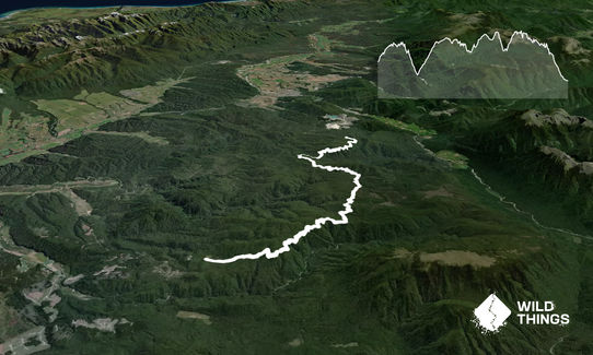
This is a really nice point-to-point run. Both road ends are a bit out of the way, so if you can arrange a key swap that's the best plan, and it's also open to mountain bikes.

Start along Soldiers Road. This old 4WD road winds through beautiful beech forest, passing several old mine shafts. Initially it climbs gradually before a descent to a creek, then climbs more steadily again to break out into some more open manuka/pakihi vegetation. From here it descends gradually again to Big River. This is almost exactly the halfway point. Here there are several signboards with information about the area's mining history. There are a few old buildings and workings, then just up the hill above there is a DoC hut - Big River Hut - with nice views over the river flat.

The hut is a very short side trip from the track. There is also the option for a slightly longer side trip (approx 2km each way) to Big River Dam. Ignore signs to Inangahua (this track heads east across Big River) - instead continue to follow DoC signs to Waiuta. From Big River the route on becomes single track, again heading through mature beech forest. The boggier areas now have short boardwalks over them, but it can still be pretty wet underfoot. The track climbs up over a small bush saddle (the track's high point) then undulates gradually downwards before popping out onto gravel road just before Waiuta. This is a really interesting area to have a look around too if you still have the energy!
Lots of old mine workings and building, particularly around Big River

If you know of any public toilets near the trail start or on the route, please login and then let us know so we can update this section.

No public transport, adequate parking

13 km

12 minutes

Yes

No

Easy.

Very patchy.

Seam-sealed waterproof jacket, Beanie/thermal headwear, Personal Locator Beacon (PLB), Whistle, First aid kit, Extra food for emergencies, Cellphone, Map

Plenty of drinkable water from creeks and rivers along the way, or fill up at Big River Hut

Muddy most of the time

You and Big River - Waiuta

As a VIP member you can record private notes for this trail, see all of your times and more.

Register Now

Already have an account? Login now

Trail Reviews

Be the first to submit a review for Big River - Waiuta!

Login to submit a review

Trail Running Community

Find people who are interested in or have completed this trail run.

You must register or login to view this feature.

Register Now

Overlapping Trails

These overlap with this trail to some degree. You may wish to combine them but please note that to qualify for FKTs on these runs you should record a separate activity for each.

Waiuta Ghost Town

Waiuta Ghost Town

Length: 23.7km

Level: Intermediate

Other trails nearby
Kirwans Track Loop

Kirwans Track Loop

Length: 38.4km

Level: Intermediate

Progress Water Race Track - AKA Stairmaster 2000

Progress Water Race Track - AKA Stairmaster 2000

Length: 5.1km

Level: Beginner

Montgomerie Hut via Gannons

Montgomerie Hut via Gannons

Length: 27.5km

Level: Beginner - Intermediate

Painkiller Devil's Tail loop

Painkiller Devil's Tail loop

Length: 21.0km

Level: Intermediate - Experienced

Find more trails and peaks nearby